
Pedestrian navigation method based on inertia, magnetic heading and zero-speed correction

A zero-speed correction and pedestrian navigation technology, which is applied in directions such as navigation, navigation, and ground navigation through speed/acceleration measurement. Problems such as state transition matrix F matrix and observation matrix H matrix

Active Publication Date: 2019-12-10
NANJING FORESTRY UNIV
View PDF6 Cites 15 Cited by
  • Summary
  • Abstract
  • Description
  • Claims
  • Application Information

AI Technical Summary

Problems solved by technology

However, the current published literature does not give the specific forms of the system state equation and measurement equation of the pedestrian positioning system, let alone the state transition matrix F matrix and observation matrix H matrix in the equation, which need to be selected according to the system error model and The state quantity of the system can only be obtained after careful design and calculation, which is the core part of the zero-speed correction technology

Method used


Image

  • Pedestrian navigation method based on inertia, magnetic heading and zero-speed correction
  • Pedestrian navigation method based on inertia, magnetic heading and zero-speed correction
  • Pedestrian navigation method based on inertia, magnetic heading and zero-speed correction

Examples


Embodiment 1

[0167] Apply the above-mentioned pedestrian navigation method to the outdoor test, as follows:

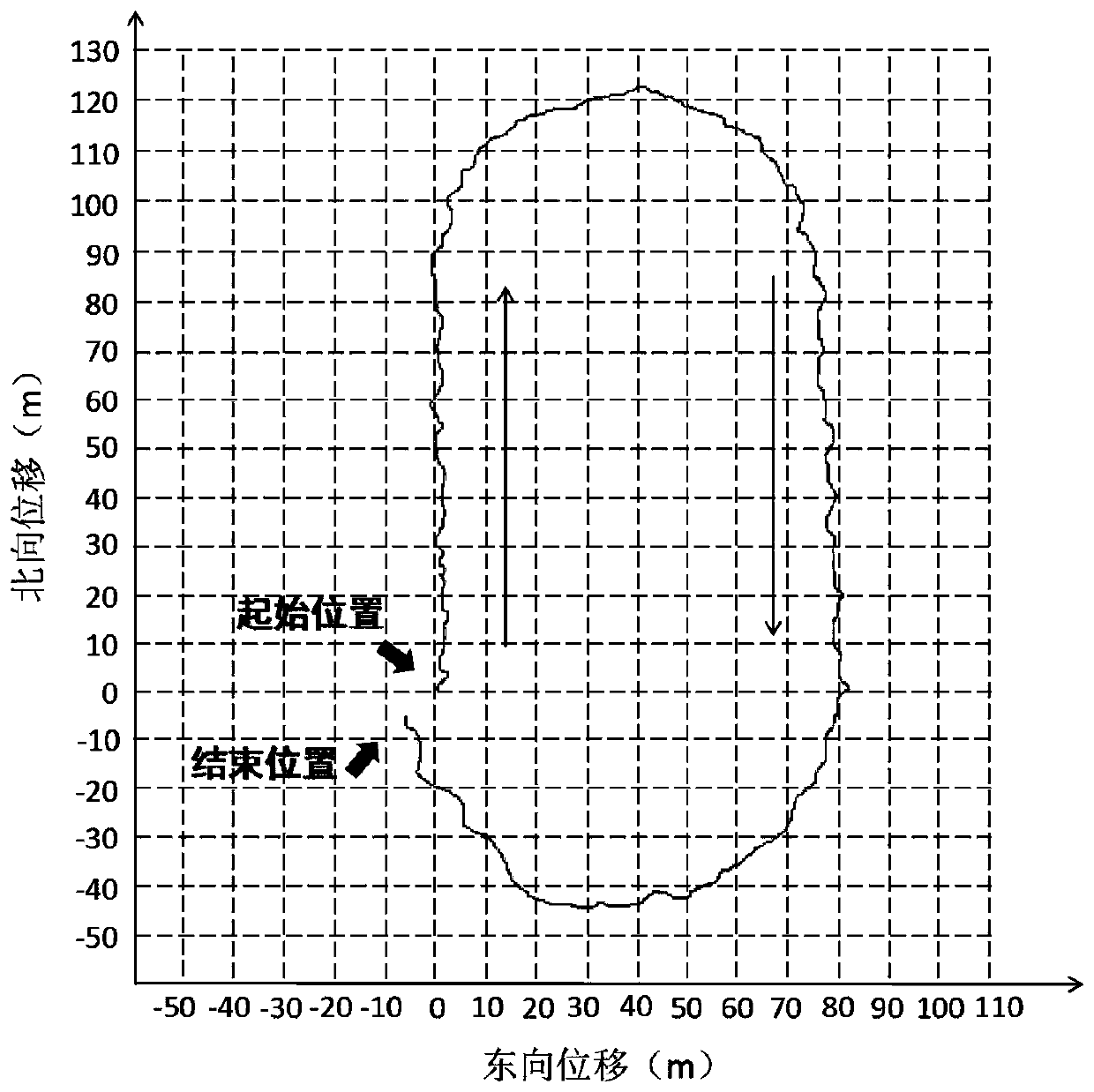
[0168] Such as figure 2 As shown, it is the plane displacement diagram of the outdoor walking experiment of the pedestrian navigation system, in which the thin black line represents the displacement curve of the pedestrian navigation system using zero-speed correction and magnetic heading assistance.

[0169] The outdoor experiment site is the new playground of our school. In a clockwise direction, along the innermost white line of the 400m runway, from the starting point shown in the picture, walk around the playground clockwise at a constant speed, and finally return to the starting position to complete the entire experiment The travel time is about 5 minutes and 37 seconds. Before starting to walk, first stand still at the starting position for 30 seconds to complete the initial alignment. Because the start position and end position of the experiment are the same, the positio...

Embodiment 2

[0174] The pedestrian navigation method described above was applied to indoor experiments, as follows:

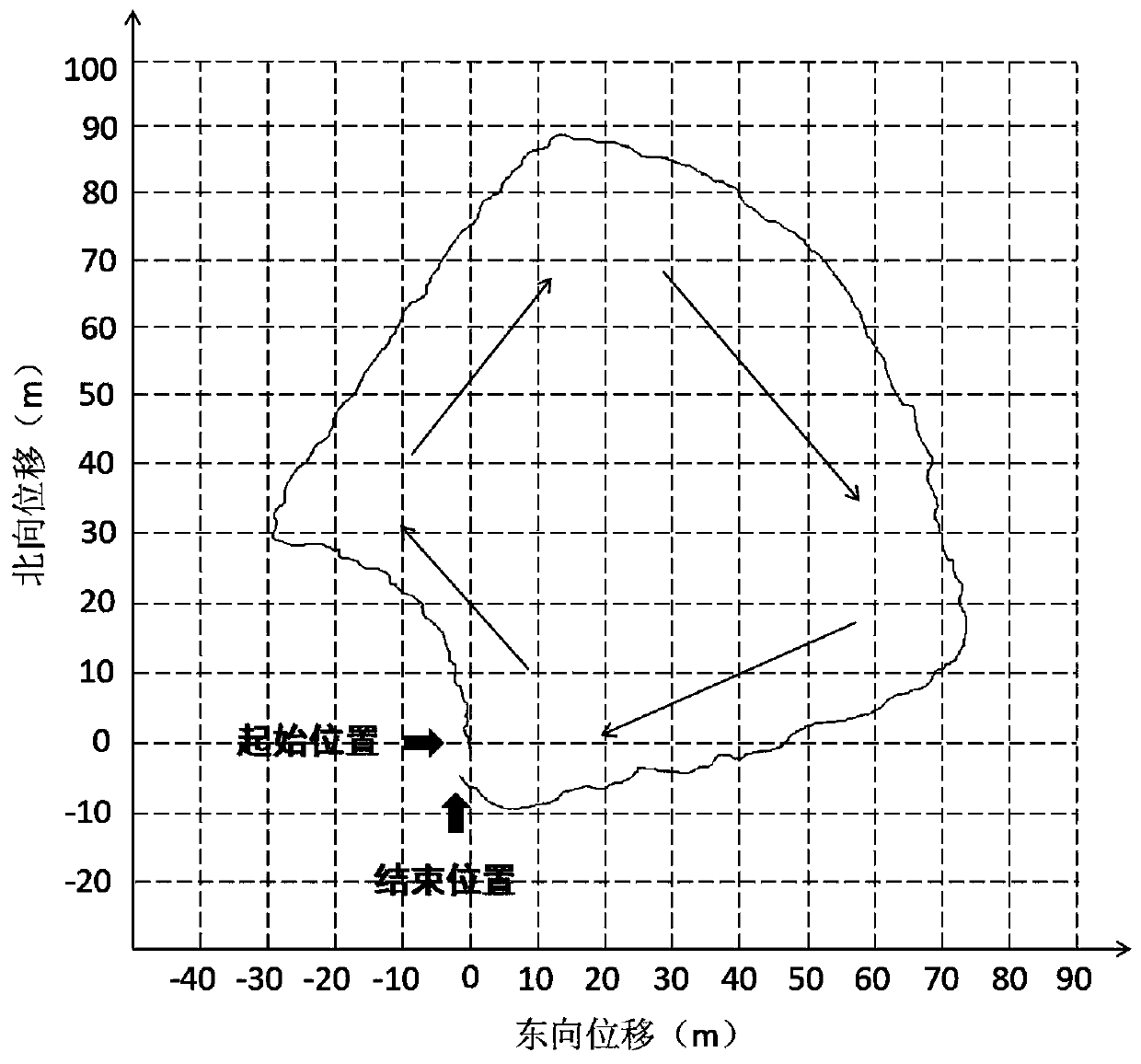
[0175] Such as image 3 As shown, the four areas of ABCD are connected by corridors, so walk clockwise along the wall at a constant speed, and finally return to the starting position. The walking time is about 4 minutes and 02 seconds. Before starting to walk, first stand still at the starting position for 30 seconds to complete the initial alignment. The thin black line represents the displacement curve of the pedestrian navigation system using zero speed correction and magnetic heading assistance.

[0176] Since the traditional satellite positioning system is not used, the closed indoor environment does not affect the work of the pedestrian navigation system.

[0177] The error distance and error proportion are shown in Table 2. Due to the shortened walking time, the final error distance and error proportion data are reduced to a certain extent compared with long-distan...


PUM


Abstract

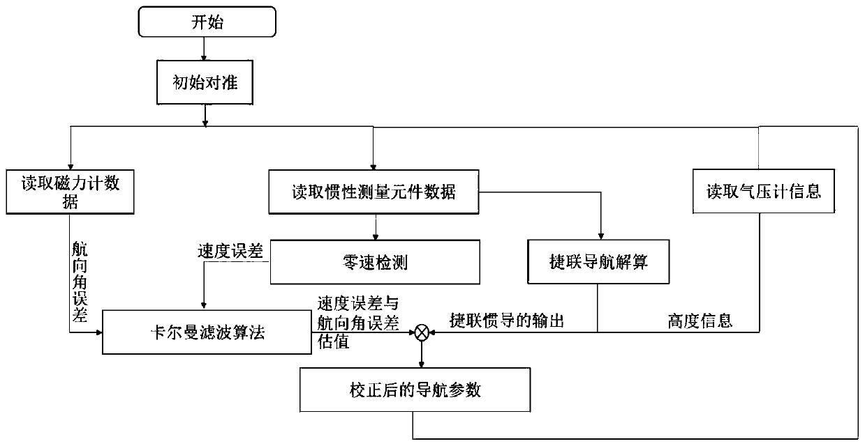
The invention discloses a pedestrian navigation method based on inertia, magnetic heading and zero-speed correction, which comprises the following steps: (1) measuring linear motion information and angular motion information of a pedestrian by adopting an inertia measurement element, and resolving to obtain attitude, speed and position information of the pedestrian; calculating the three-axis magnetic component measured by a magnetometer to obtain the heading information of the pedestrian; and (2) obtaining a zero-speed state in a walking process through a zero-speed interval detection algorithm, updating an observed quantity of a speed error in the state, establishing a Kalman filtering equation to carry out error correction on pedestrian navigation output in combination with the observedquantity of a course angle error, and finally completing output of corresponding navigation information. Therefore, the magnetic heading angle is calculated by utilizing the three-axis magnetic induction data, and the defects of an inertial navigation system are overcome. In the process, a zero-speed interval is judged by utilizing measurement data of an inertia measurement element, a system error model and a Kalman filtering equation are established, a proper observed quantity is selected, and a state error is estimated.

Description

technical field [0001] The invention relates to a pedestrian navigation method based on inertial and magnetic heading and zero-speed correction. Background technique [0002] Traditional pedestrian navigation technology is mostly based on satellite positioning, such as GPS or Beidou. But in some special occasions, such as when a forest fire breaks out in a deep mountain, the shielding of the mountain often makes the satellite navigation system unable to work. In addition, satellite navigation systems often fail when people are walking on high-rise streets or indoors. In real life, some special fields need to locate personnel quickly and accurately even when satellite positioning signals fail. In these cases, how to obtain accurate pedestrian navigation / location information is very important. The principle of inertial navigation is based on Newton's classical mechanics. It uses the angular motion and linear motion information of the carrier provided by inertial measurement...

Claims


Application Information

Patent Timeline
IPC IPC(8): G01C21/16G01C21/08
CPCG01C21/165G01C21/08
Inventor 黄磊桑迪李赵春陆荣鑑徐兆军
Owner NANJING FORESTRY UNIV
Learn More