A high-precision anti-seismic surveying and mapping device for water conservancy and hydropower projects

A technology of water conservancy and hydropower, surveying and mapping equipment, applied in the direction of spring/shock absorber, machine platform/support, vibration suppression adjustment, etc., can solve the problems of affecting the work process, large error of surveying and mapping results, damage to the measuring instrument, etc., to achieve improvement Accuracy, improved stability, less shaking effect

Active Publication Date: 2020-08-04
SICHUAN UNIV
View PDF7 Cites 0 Cited by
  • Summary
  • Abstract
  • Description
  • Claims
  • Application Information

AI Technical Summary

Problems solved by technology

[0006] The purpose of the present invention is to solve the problem that existing surveying and mapping devices are easily affected by external wind force, vibration caused by people's activities, and ground vibration during water flow, so that the surveying and mapping instrument vibrates during surveying and mapping, which in turn affects surveying and mapping The levelness of the instrument, etc., makes the surveying and mapping results have large errors, which affects the subsequent work process; at the same time, when the height of the surveying and mapping device that needs to be adjusted is too high, the stability of the surveying and mapping device itself is poor, and it is easy to fall down during the vibration process. The problem of affecting the measurement results and damaging the measuring instrument, and a high-precision anti-seismic surveying and mapping device for water conservancy and hydropower projects

Method used


Image

  • A high-precision anti-seismic surveying and mapping device for water conservancy and hydropower projects
  • A high-precision anti-seismic surveying and mapping device for water conservancy and hydropower projects
  • A high-precision anti-seismic surveying and mapping device for water conservancy and hydropower projects

Examples


Embodiment 1

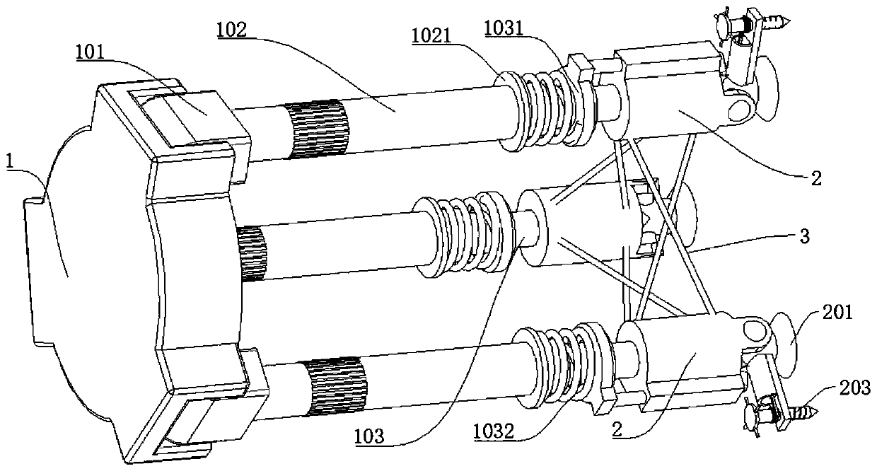
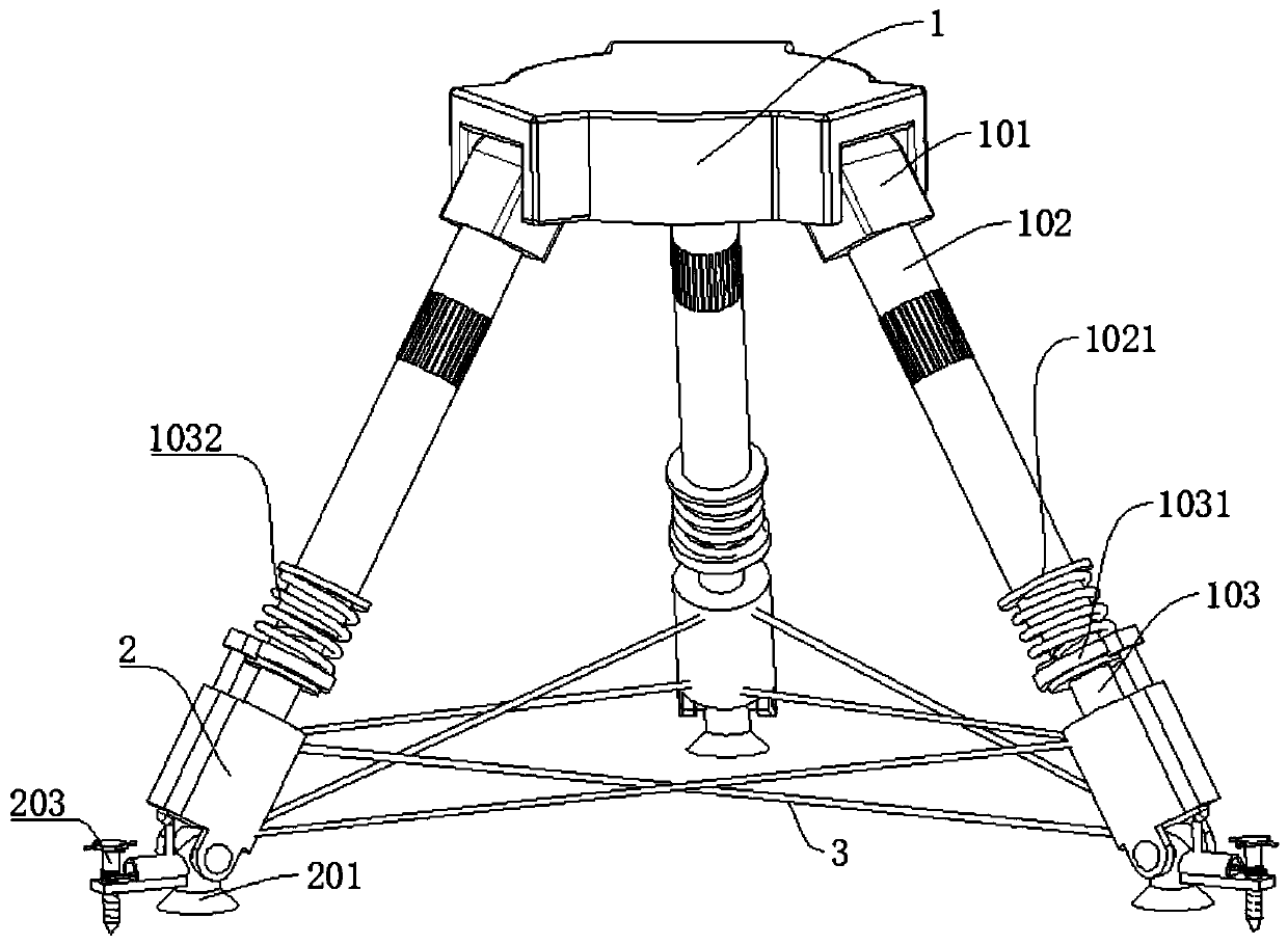
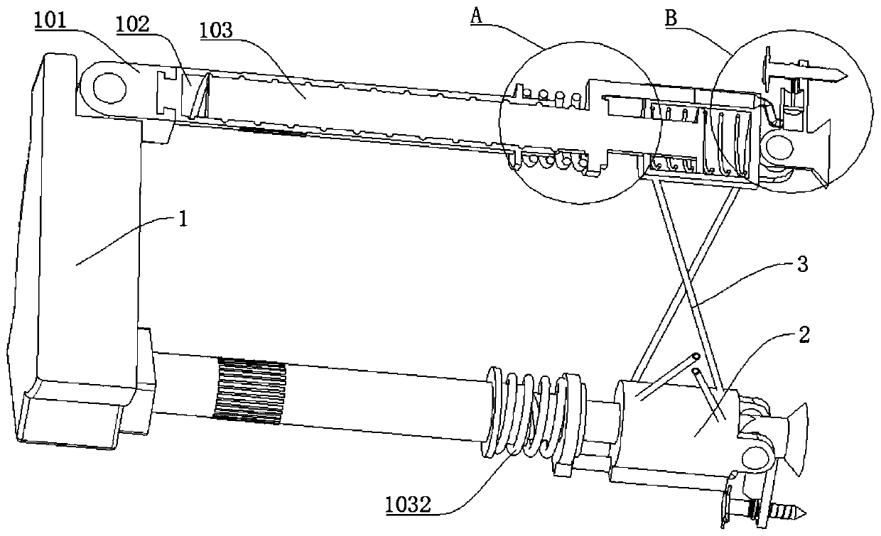
[0044] refer to Figure 1-8 , a high-precision shockproof surveying and mapping device for water conservancy and hydropower projects, comprising a fixed plate 1 and a first piston cylinder 2, the fixed plate 1 is rotatably connected with a plurality of connecting plates 101, and a single connecting plate 101 is rotatably connected with a first Adjusting the bracket 102, the first adjusting bracket 102 is threadedly connected with the second adjusting bracket 103, the first adjusting bracket 102 is fixedly connected with the first bracket plate 1021, the second adjusting bracket 103 is fixedly connected with the second bracket plate 1031, the second adjusting bracket 103 is fixedly connected with the second bracket plate 1031, A bracket plate 1021 is connected to the second bracket plate 1031 through the first spring 1032, and the end of the second adjustment bracket 103 away from the fixed plate 1 is fixedly connected with the first piston plate 1033, and the first piston plate...

Embodiment 2

[0056] refer to Figure 1-8 , a high-precision shockproof surveying and mapping device for water conservancy and hydropower projects, which is basically the same as Embodiment 1, the difference is that a connecting bracket 202 is fixedly connected to the supporting leg 201, and the connecting bracket 202 and the fixing leg 203 are connected by threads, and the fixing leg 203 A turntable 204 is fixedly connected to one end close to the fixed plate 1 .

[0057] A handle 2041 is fixedly connected to the turntable 204 .

[0058] When the user is in use, by turning the handle 2041, it is convenient to turn the turntable 204, and then drive the fixed leg 203 to rotate. The fixed legs 203 are inserted into the soil surface to prevent the external shock from causing the device to fall to the ground and improve the stability of the device;

[0059] The device can improve the stability of the whole surveying and mapping device and prevent the device from falling to the ground.

Embodiment 3

[0061] refer to Figure 1-8 , a high-precision shockproof surveying and mapping device for water conservancy and hydropower engineering, which is basically the same as Embodiment 1 or 2, furthermore, the first piston cylinder 2 is fixedly connected with the second piston cylinder 2001, and the piston rod 104 is slidingly connected to the second Inside the piston barrel 2001, the second piston barrel 2001 is connected to the connecting bracket 202 through the second connecting pipe 2002, the second piston plate 2021 is slidably connected to the connecting bracket 202, and the end of the second piston plate 2021 away from the support leg 201 is fixedly connected to a sliding plate 2022 , the fixed leg 203 is fixedly connected with a gear part 2031 , and the sliding plate 2022 is provided with tooth slots matching the gear part 2031 .

[0062] The gear member 2031 is a one-way gear.

[0063] A buffer pad is provided at the joint between the gear member 2031 and the connecting br...


PUM


Abstract

The invention discloses a high-precision anti-shock surveying and mapping device for water conservancy and hydropower projects, which belongs to the technical field of surveying and mapping devices. A high-precision anti-vibration surveying and mapping device for water conservancy and hydropower projects, including a fixed plate and a first piston cylinder. The fixed plate is rotatably connected to a plurality of connecting plates, and each of the connecting plates is rotatably connected to a first adjustment bracket. , the first adjusting bracket is threadedly connected with a second adjusting bracket, the first adjusting bracket is fixedly connected with a first bracket plate, the second adjusting bracket is fixedly connected with a second bracket plate, and the first adjusting bracket is fixedly connected with a second bracket plate. The support plate is connected with the second support plate through the first spring, and the end of the second adjustment support away from the fixed plate is fixedly connected with the first piston plate. The present invention can increase the stability of the surveying and mapping device, and provide the shock resistance of surveying and mapping. At the same time, the accuracy of the surveying and mapping device is improved, so that the data obtained in the surveying and mapping of water conservancy and hydropower projects are more accurate.

Description

technical field [0001] The invention relates to the technical field of surveying and mapping devices, in particular to a high-precision shockproof surveying and mapping device for water conservancy and hydropower projects. Background technique [0002] Water is the basic element that human beings depend on for survival, and electricity is the main energy source for social development. The discipline of water conservancy and hydropower engineering is an engineering science that regulates and utilizes water energy resources with engineering or non-engineering measures on the basis of the study of the natural characteristics of water. Water conservancy The major of hydropower engineering focuses on the planning, design, construction, and management of large and medium-sized water conservancy and hydropower projects and their buildings, including dams, hydropower plant buildings, gates, water intake, diversion, and discharge structures, as well as industrial hydraulic structures....

Claims


Application Information

Patent Timeline
Patent Type & Authority Patents(China)
IPC IPC(8): F16M11/32F16M11/04F16F15/04F16F15/023F16F15/08
CPCF16F15/023F16F15/04F16F15/08F16M11/043F16M11/32
Inventor 杨正丽项霞吴宇峰鲁恒夏鹏飞李国鸿
Owner SICHUAN UNIV
Why Eureka
Try Eureka