Regional ionospheric TEC real-time monitoring method based on IGS and CORS

An ionospheric and regional technology, applied in the field of satellite navigation, can solve the problems of low spatial resolution and time resolution, low precision, and inability to make real-time corrections, so as to expand the range, improve accuracy and reliability, and improve accuracy Effect

Active Publication Date: 2019-12-13
GUILIN UNIV OF ELECTRONIC TECH
View PDF14 Cites 7 Cited by
  • Summary
  • Abstract
  • Description
  • Claims
  • Application Information

AI Technical Summary

Problems solved by technology

The International GNSS Service (InternalGNSS Service, IGS) began to use the global IGS network to extract global ionospheric information in 1998, and released global ionospheric TEC grid products. The electronic content of 5°(longitude)×2.5°(latitude) grid points in 2 hours, but its spatial resolution and time resolution are low, and the accuracy is not high when it is applied to a small area, and there is a 24-hour delay. make real-time corrections

Method used


Image

  • Regional ionospheric TEC real-time monitoring method based on IGS and CORS
  • Regional ionospheric TEC real-time monitoring method based on IGS and CORS
  • Regional ionospheric TEC real-time monitoring method based on IGS and CORS

Examples


Embodiment Construction

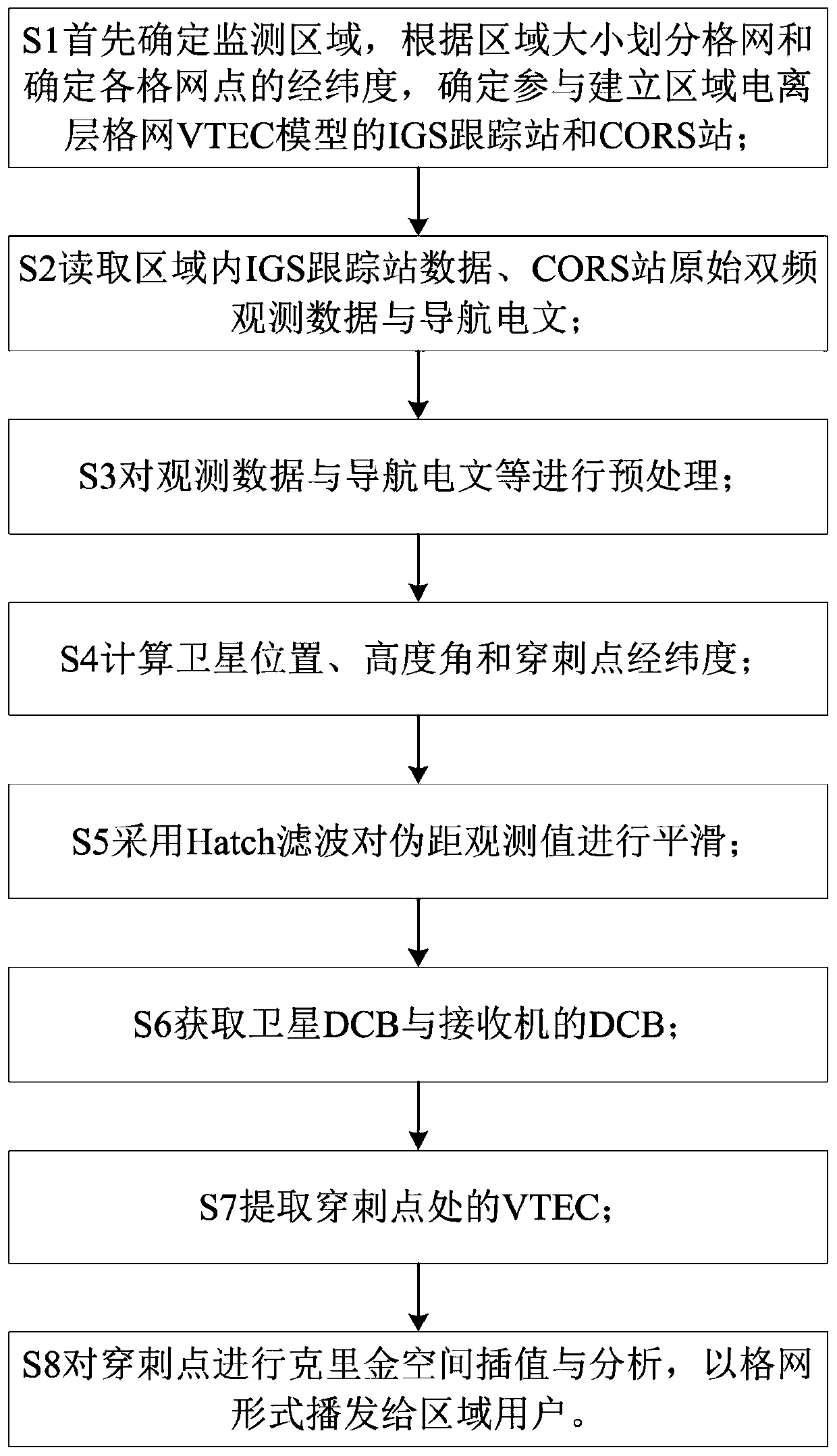
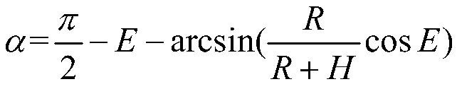
[0042] Embodiments of the present invention are described below through specific examples, and those skilled in the art can easily understand other advantages and effects of the present invention from the content disclosed in this specification. The present invention can also be implemented or applied through other different specific implementation modes, and various modifications or changes can be made to the details in this specification based on different viewpoints and applications without departing from the spirit of the present invention. It should be noted that, in the case of no conflict, the following embodiments and features in the embodiments can be combined with each other.

[0043] It should be noted that the diagrams provided in the following embodiments are only schematically illustrating the basic ideas of the present invention, and only the components related to the present invention are shown in the diagrams rather than the number, shape and shape of the compo...


PUM


Abstract

The invention provides a regional ionospheric TEC (Total Electron Content) real-time monitoring method based on IGS (Internal GNSS Service) and CORSs (Continuously Operating Reference Station), whichcomprises the steps as follows: determining a monitoring region, and dividing the monitoring region into grids according to the size of the monitoring region; determining the longitude and latitude ofeach grid, and determining IGS tracking stations and CORSs participating in establishment of a regional ionospheric grid VTEC (Vertical Total Electron Content) model; reading the data of the IGS tracking stations, the original double-frequency observation data of the CORSs and a navigation message; preprocessing the observation data and the navigation message; calculating the position and elevation angle of a satellite and the longitude and latitude of a puncture point; smoothing a pseudo-range observation value; acquiring the DCB (Difference Code Bias) of the satellite and the DCB of a receiver; extracting the VTEC at the puncture point; carrying out Kriging spatial interpolation and analysis on the puncture point, and broadcasting the result to regional users in a grid form. According to the method, a regional ionospheric grid VTEC model is established by combining IGS and CORS data, the problems of precision reduction and the like caused by insufficiency of the IGS tracking stations are solved, the range of a monitoring region is expanded, and the precision and reliability of the ionospheric grid VTEC model in areas such as the equator are improved.

Description

technical field [0001] The invention belongs to the field of satellite navigation, and in particular relates to a real-time monitoring method for regional ionosphere TEC based on IGS and CORS stations. Background technique [0002] The ionosphere is an atmospheric region at a height of 60-2000 km from the ground. The thin air is ionized by ultraviolet rays and X-rays to generate a large number of free electrons, forming plasma, which can cause differences in electromagnetic signals passing through it, including reflection, refraction, scattering and absorption. degree of influence. Ionospheric total electron content (Total Electron Contents, TEC) is one of the most important parameters to describe the characteristics and changes of the ionosphere. It has important application value and scientific significance to improve the positioning accuracy of GNSS and promote the development of theoretical research and engineering application of related science. [0003] GNSS is one o...

Claims


Application Information

Patent Timeline
Patent Type & Authority Applications(China)
IPC IPC(8): G01S19/07
CPCG01S19/07
Inventor 孙希延游梦琳纪元法严素清付文涛陈奇东陈新李捷
Owner GUILIN UNIV OF ELECTRONIC TECH
Why Eureka
Try Eureka