
Fruit tree identification and quantity monitoring method and system based on unmanned aerial vehicle data acquisition

A technology for data collection and unmanned aerial vehicles, applied in image data processing, neural learning methods, character and pattern recognition, etc., can solve problems such as good discrimination, high stability, failure of fruit tree recognition, and achieve accurate recognition and improve statistics. Accuracy, avoidance of adverse effects

Active Publication Date: 2019-12-13
INST OF AGRI RESOURCES & REGIONAL PLANNING CHINESE ACADEMY OF AGRI SCI
View PDF7 Cites 14 Cited by
  • Summary
  • Abstract
  • Description
  • Claims
  • Application Information

AI Technical Summary

Problems solved by technology

For example, the same fruit tree may appear in multiple images taken by the drone. If deduplication is not performed, there will be a double counting problem, which will affect the accuracy of the calculation results.
In addition, the overall image of the park obtained after the drone image stitching, because its size exceeds the maximum limit of the image size that can be processed by the image processing algorithm at a time, often needs to be segmented before fruit tree recognition processing
On the segmentation boundary, there is a phenomenon that a tree is segmented in different sub-images, which easily leads to the failure of the fruit tree recognition, or the fruit tree is recognized as a fruit tree in two or more sub-images at the same time, which also leads to The fruit trees are counted repeatedly, which affects the final accuracy of the orchard count
[0008] To sum up, first, the spectral (color) feature is not an ideal feature with high stability and good discrimination in fruit tree identification and extraction, which may affect the accuracy of fruit tree identification and the environmental adaptability of the identification method

Method used


Image

  • Fruit tree identification and quantity monitoring method and system based on unmanned aerial vehicle data acquisition
  • Fruit tree identification and quantity monitoring method and system based on unmanned aerial vehicle data acquisition
  • Fruit tree identification and quantity monitoring method and system based on unmanned aerial vehicle data acquisition

Examples


Embodiment Construction

[0031] Embodiments of the present invention are described below with reference to the drawings, in which like parts are denoted by like reference numerals. In the case of no conflict, the following embodiments and the technical features in the embodiments can be combined with each other.

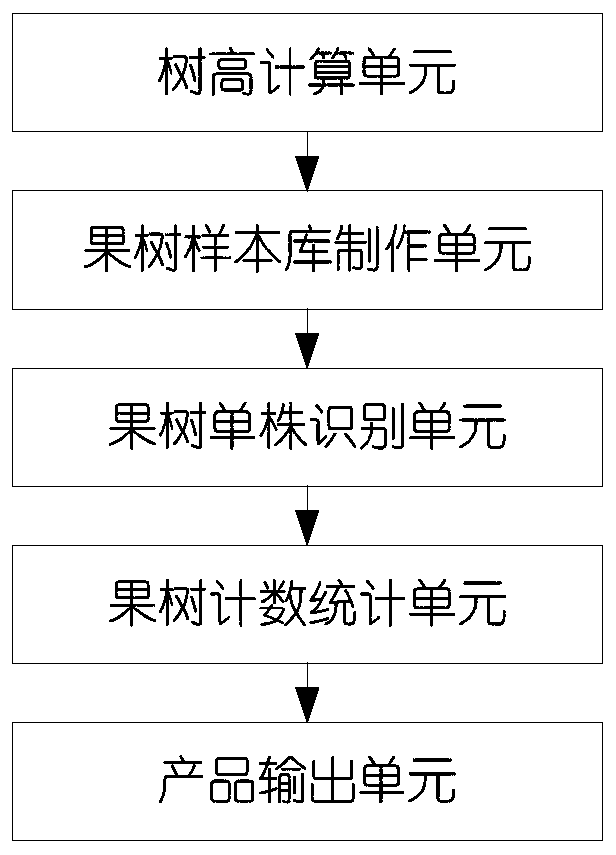
[0032] The present invention provides a fruit tree identification and quantity monitoring system based on UAV data collection, such as figure 1 As shown, the system of the present invention includes: a tree height calculation unit, a fruit tree sample library making unit, a fruit tree single plant identification unit, a fruit tree counting and statistics unit and a product output unit.

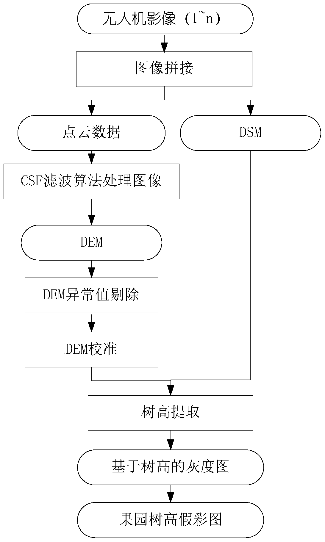
[0033] The tree height calculation unit processes the image data collected by the low-altitude remote sensing of the UAV to extract the tree height data of fruit trees, for example, the cloth simulation filter (Cloth Simulation Filter, CSF) algorithm can be used to target the three-dimensional images generat...


PUM


Abstract

The invention provides an unmanned aerial vehicle data acquisition-based fruit tree identification and quantity monitoring method, which comprises the steps of S1-1, splicing a plurality of images acquired by an unmanned aerial vehicle, and obtaining a three-dimensional point cloud data set and digital surface model DSM data according to the spliced images; S1-2, performing cloth simulation filtering CSF processing on the three-dimensional point cloud data set to obtain digital elevation model DEM data; S1-3, performing abnormal value elimination and DEM calibration on the DEM; and S1-4, calculating a difference value according to the DEM data and the DSM data to obtain tree height data of the orchard, converting the tree height data into a grayscale image, and further converting the grayscale image into a false color image. The invention further provides a corresponding system. The influence of tree shadows and weeds on unmanned aerial vehicle remote sensing image processing is solved, and the fruit tree identification and quantity statistics precision is improved.

Description

technical field [0001] The invention relates to a refined orchard management method, in particular to a fruit tree identification and quantity monitoring method and system based on unmanned aerial vehicle data collection. Background technique [0002] Orchard precision management is an important part of agricultural informatization, and it is also an effective way to improve orchard management efficiency and economic income. With the improvement of the spatial resolution of remote sensing technology and the integration of remote sensing and computer technology, many breakthroughs have been made in orchard area monitoring, pest monitoring, and individual fruit tree detection. Especially in recent years, the rapid development of UAV low-altitude remote sensing technology has made the acquisition of remote sensing data more flexible and convenient, and the cost is lower, which has promoted the application of remote sensing in agriculture. [0003] Individual identification and...

Claims


Application Information

Patent Timeline
Patent Type & Authority Applications(China)
IPC IPC(8): G06K9/00G06K9/62G06T7/60G06T7/70
CPCG06T7/60G06T7/70G06T2207/10028G06T2207/10032G06T2207/30188G06T2207/30242G06T3/4038G06T17/05G06N3/08G06T2207/20081G06T2207/20084G06F18/214
Inventor 段玉林史云张保辉吴文斌
Owner INST OF AGRI RESOURCES & REGIONAL PLANNING CHINESE ACADEMY OF AGRI SCI
Learn More