Method for inversing forest canopy aggregation index on basis of full-waveform laser radar data

A laser radar and aggregation index technology, applied in the field of spatial information, can solve problems such as low point density, inability to record changes in canopy gaps, unsuitable for aggregation index inversion, etc., to achieve simple and clear methods, strong adaptability, and clear logic Effect

Active Publication Date: 2020-01-17
BEIJING NORMAL UNIVERSITY
View PDF5 Cites 4 Cited by
  • Summary
  • Abstract
  • Description
  • Claims
  • Application Information

AI Technical Summary

Problems solved by technology

However, due to the low point density, this data cannot record small gap chang

Method used


Image

  • Method for inversing forest canopy aggregation index on basis of full-waveform laser radar data
  • Method for inversing forest canopy aggregation index on basis of full-waveform laser radar data
  • Method for inversing forest canopy aggregation index on basis of full-waveform laser radar data

Examples


Embodiment 1

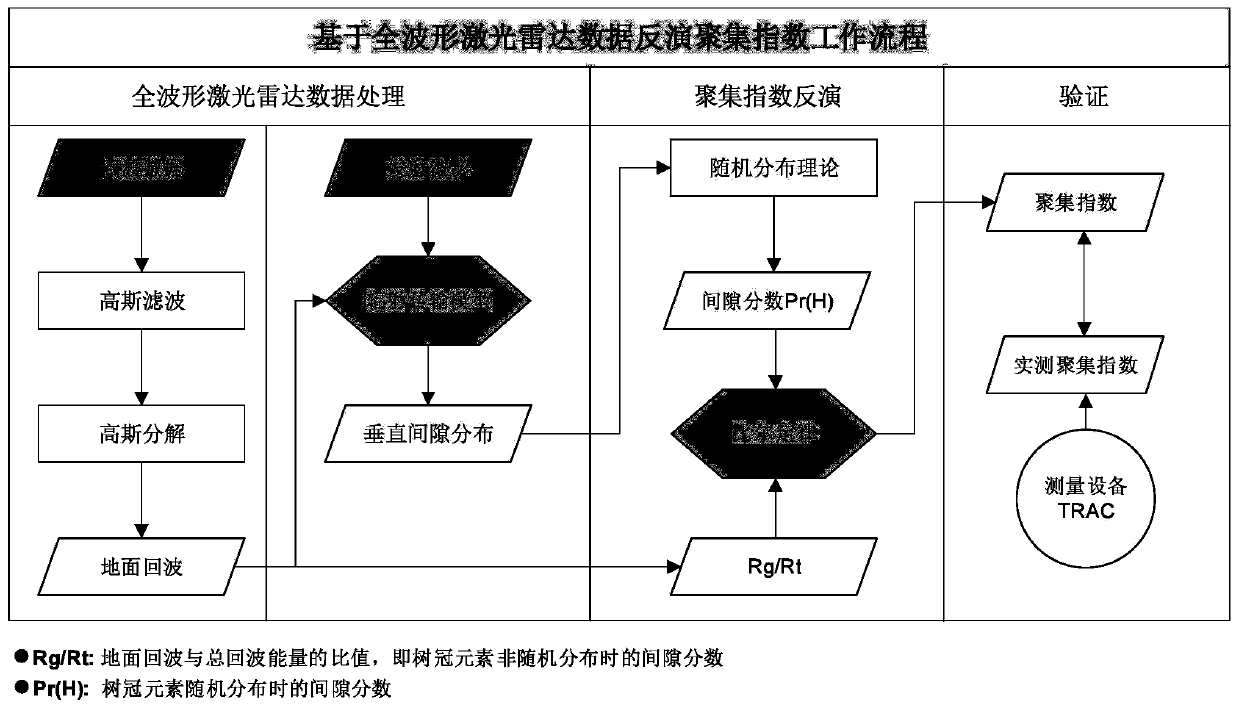
[0111] On a Lenovo ThinkStation desktop computer equipped with an Intel E3-1220@3.1GHz / 8M dual-core processor, the case implementation was carried out using the matlab programming language as an implementation tool; in this embodiment, the space-borne GLAS full-waveform lidar data as an example, according to figure 1 The shown implementation flow of the method is used to calculate the aggregation index; then, the algorithm proposed by the present invention is verified by using the aggregation index results measured in the field.

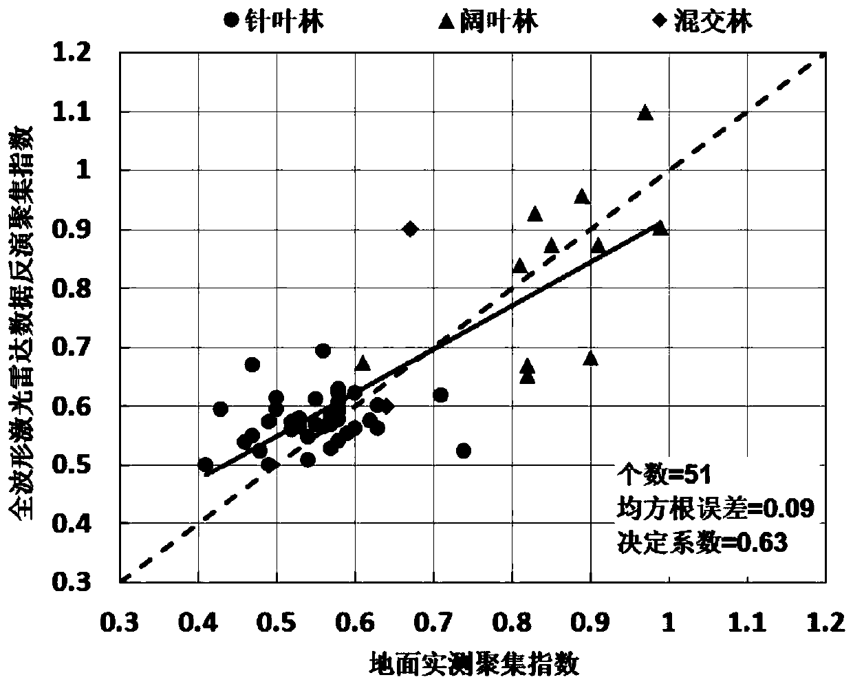
[0112] image 3 It is a scatter plot comparing the ground measured data with the result of aggregation index inverted based on the method of this patent. It can be seen from the figure that the application results of the method proposed in this patent in coniferous forest, mixed forest and broad-leaved forest all show similar results. The ground observation results are in good agreement, with a coefficient of determination of 0.63; in addition, the ...


PUM


Abstract

The invention relates to a method for inversing a forest canopy aggregation index on the basis of full-waveform laser radar data, and belongs to the technical field of spatial information. Firstly, the ratio of ground echo energy to total echo energy is utilized as a clearance score of a forest canopy of a laser radar observation area; secondly, vertical clearance distribution of the forest canopyof the laser radar observation area is calculated on the basis of a radiation transfer model only considering single scattering about laser radar, and the result is further used for calculating a canopy clearance score of a crown branch and leaf element in a random distribution state; and finally, by taking the obtained canopy clearance score of the crown branch and leaf element in the random distribution state and a clearance score of the crown branch and leaf element in a nonrandom distribution state as inputs, the aggregation index of the forest canopy is solved on the basis of the Beer'slaw. By utilizing the method, inversion of the high-resolution forest canopy aggregation index can be achieved. The method has the important research significance and application value in the field ofresearching for quantitative remote sensing of forest vegetation.

Description

[0001] 1. Technical field [0002] The invention relates to a method for retrieving forest canopy aggregation index based on full-waveform laser radar data, and belongs to the field of spatial information technology. [0003] 2. Background technology [0004] The aggregation index describes the spatial distribution pattern of leaves and is an important input parameter in the modeling of ecological, hydrological and land surface processes. It is also of great significance in applications related to remote sensing. For example, it is a necessary parameter for estimating the true leaf area index; it can improve the estimation accuracy of net primary productivity and gross primary productivity, etc. [0005] At present, many methods for retrieving vegetation aggregation index have been developed based on ground and satellite observation data. Ground observation methods mainly include: (1) digital hemispheric photography; (2) plant canopy analyzer; (3) multi-band vegetation imager;...

Claims


Application Information

Patent Timeline
IPC IPC(8): G01S17/89G01S7/48
CPCG01S17/89G01S7/4802
Inventor 崔磊焦子锑孙梅
Owner BEIJING NORMAL UNIVERSITY
Why Eureka
Try Eureka