
Terrain prediction method, device and system of rotary microwave radar and unmanned aerial vehicle

A technology of microwave radar and prediction method, which is applied in the field of unmanned aerial vehicles, can solve the problems of limited installation position of rotating microwave radar, affecting the accuracy of terrain prediction, and the inability of target points to accurately and comprehensively reflect ground information, etc., to achieve comprehensive measurement, The effect of improving accuracy and increasing the scanning range

Pending Publication Date: 2020-02-07
SZ DJI TECH CO LTD
View PDF14 Cites 8 Cited by
  • Summary
  • Abstract
  • Description
  • Claims
  • Application Information

AI Technical Summary

Problems solved by technology

However, in actual situations, due to the limited installation position of the rotating microwave radar, the measured target points cannot accurately and comprehensively reflect the ground information, thus affecting the accuracy of terrain prediction.

Method used


Image

  • Terrain prediction method, device and system of rotary microwave radar and unmanned aerial vehicle
  • Terrain prediction method, device and system of rotary microwave radar and unmanned aerial vehicle
  • Terrain prediction method, device and system of rotary microwave radar and unmanned aerial vehicle

Examples


Embodiment Construction

[0028] In order to make the purpose, technical solutions and advantages of the embodiments of the present invention clearer, the technical solutions in the embodiments of the present invention will be clearly and completely described below in conjunction with the drawings in the embodiments of the present invention. Obviously, the described embodiments It is a part of embodiments of the present invention, but not all embodiments. Based on the embodiments of the present invention, all other embodiments obtained by persons of ordinary skill in the art without creative efforts fall within the protection scope of the present invention.

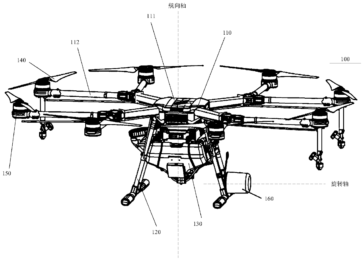
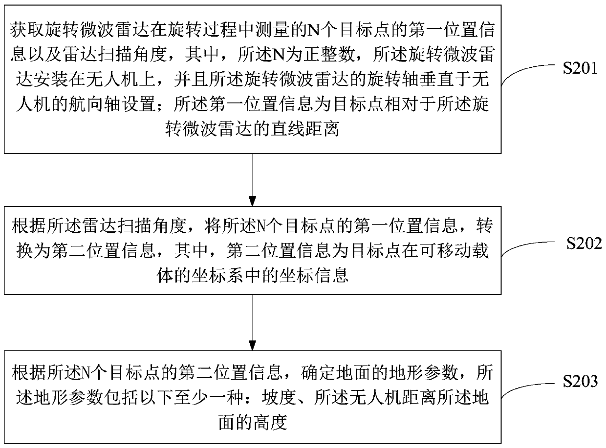
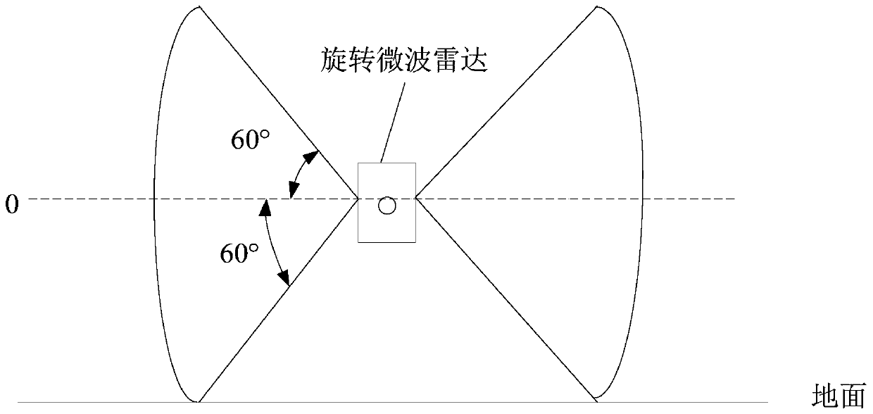
[0029] Embodiments of the present invention provide a terrain prediction method, device, system and unmanned aerial vehicle of a rotating microwave radar. The unmanned aerial vehicle may be a rotorcraft, for example, a multi-rotor aircraft propelled by a plurality of propulsion devices through the air, and embodiments of the present invention are ...


PUM


Abstract

The invention discloses a terrain prediction method, device and system of a rotary microwave radar and an unmanned aerial vehicle. The method comprises the following steps: acquiring first position information of N target points measured by the rotary microwave radar in a rotation process and a radar scanning angle, wherein a rotating shaft of the rotating microwave radar is perpendicular to a heading axis of the unmanned aerial vehicle, converting the first position information of the N target points into second position information, and determining terrain parameters of the ground, such as gradient, height from the unmanned aerial vehicle to the ground and the like, according to the second position information of the N target points and a radar scanning angle. The rotating shaft of the rotating microwave radar is perpendicular to the heading axis of the unmanned aerial vehicle, so that the scanning range of the rotating microwave radar to the horizontal plane can be enlarged, the ground can be accurately and comprehensively measured, and the ground measurement accuracy is improved.

Description

technical field [0001] Embodiments of the present invention relate to the technical field of unmanned aerial vehicles, and in particular to a terrain prediction method, device, system and unmanned aerial vehicle of a rotating microwave radar. Background technique [0002] At present, drones can be used in many scenarios. For example, in the power industry, it is necessary to inspect cables in a large area and reconstruct 3D images of cables in real time. In terms of the second generation of agricultural drones, a 360° horizontal plane is proposed. function indicators. In these operating scenarios, most drones need to fly close to the ground and avoid accidentally hitting the ground when climbing. On relatively flat ground, based on the data of the Global Positioning System (GPS) and the Inertial Measurement Unit (IMU), the UAV can complete the above tasks more smoothly; The drone needs to adjust its actions in advance, such as climbing, descending, decelerating, braking, e...

Claims


Application Information

Patent Timeline
IPC IPC(8): G01S13/88G01S7/02G01C9/00B64C27/08B64D47/00
CPCG01S13/88G01S13/882G01S7/02G01C9/005B64C27/08B64D47/00B64U10/25B64U2101/00
Inventor 王石荣王春明
Owner SZ DJI TECH CO LTD
Features
  • Generate Ideas
  • Intellectual Property
  • Life Sciences
  • Materials
  • Tech Scout
  • Unparalleled Data Quality
  • Higher Quality Content
  • 60% Fewer Hallucinations
Learn More