Universal loading method for local coordinate system map

A coordinate system and coordinate system conversion technology, applied in the field of geographic information, can solve the problem that Mapbox cannot load local coordinate system maps, etc., and achieve the effect of great practical significance

Active Publication Date: 2020-02-28
吉奥时空信息技术股份有限公司
View PDF4 Cites 4 Cited by
  • Summary
  • Abstract
  • Description
  • Claims
  • Application Information

AI Technical Summary

Problems solved by technology

[0006] In view of the above problems, the purpose of the present invention is to provide a universal loading method for local coordinate system maps based on WebGL, aiming at solving the technical problem that Mapbox cannot load local coordinate system maps

Method used


Image

  • Universal loading method for local coordinate system map
  • Universal loading method for local coordinate system map
  • Universal loading method for local coordinate system map

Examples


Embodiment Construction

[0033] In order to make the object, technical solution and advantages of the present invention clearer, the present invention will be further described in detail below in conjunction with the accompanying drawings and embodiments. It should be understood that the specific embodiments described here are only used to explain the present invention, not to limit the present invention.

[0034] In order to illustrate the technical solutions of the present invention, specific examples are used below to illustrate.

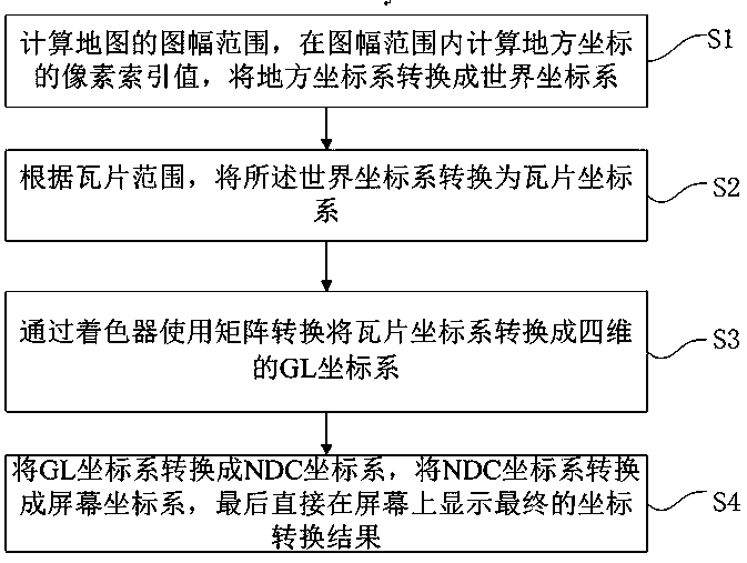
[0035] figure 1 It shows the flow of the general loading method for the local coordinate system map provided by the embodiment of the present invention, and only shows the part related to the embodiment of the present invention for the convenience of description.

[0036] Such as figure 1 Shown, the present embodiment method comprises the following steps:

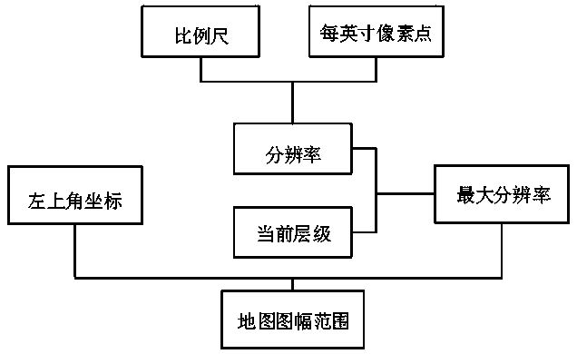
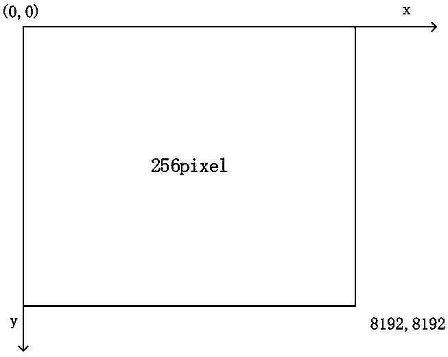
[0037] Step S1 , in the current local coordinate system, calculate the range of the map frame, calculate the pix...


PUM


Abstract

The method is suitable for the technical field of geographic information. The invention provides a universal loading method for a local coordinate system map. An engine framework Mapbox is rendered based on a WebGL map. A series of coordinate transformation is carried out, the local coordinate system is converted into the world coordinate system, the problem of coordinate conversion is well solvedby calculating the range of the map sheet and the pixel index value, a good solution is provided for supporting the local coordinate system, the actual application requirements of many industries, especially the territorial industry, are met, and the method has great practical significance.

Description

technical field [0001] The invention belongs to the technical field of geographic information, and in particular relates to a general loading method for maps based on a local coordinate system. Background technique [0002] With the enrichment of human material life and the improvement of cognitive level, the traditional two-dimensional GIS (geographic information system, geographic information system) can no longer satisfy people's cognition of the three-dimensional space in which they live, and a new way is needed to express three-dimensional world. With the development of computer technology, especially computer graphics, 3D simulation technology, virtual reality technology and network communication technology, the traditional 2D GIS has been injected with new vitality. The 3D WebGIS formed by the combination of Web3D (World Wide Web 3D) technology and GIS (World Wide Web Geographic Information System) has become an important direction of GIS development. [0003] The d...

Claims


Application Information

Patent Timeline
Patent Type & Authority Applications(China)
IPC IPC(8): G06F16/29
CPCG06F16/29
Inventor 刘宏磊吴杰刘池凯
Owner 吉奥时空信息技术股份有限公司
Why Eureka
Try Eureka