UAV real-time path planning method for urban scene reconstruction

A technology for real-time path planning and scene reconstruction, which is applied in scene recognition, unmanned aerial vehicles, motor vehicles, etc. Effect

Active Publication Date: 2021-06-04
BEIHANG UNIV
View PDF5 Cites 0 Cited by
  • Summary
  • Abstract
  • Description
  • Claims
  • Application Information

AI Technical Summary

Problems solved by technology

The invention has strong robustness, solves the time-consuming and labor-intensive problem of using a rough model as a priori for path planning in the prior art, and overcomes the limitation that the current technology is difficult to generate a three-dimensional model of a city with details

Method used


Image

  • UAV real-time path planning method for urban scene reconstruction
  • UAV real-time path planning method for urban scene reconstruction
  • UAV real-time path planning method for urban scene reconstruction

Examples


Embodiment Construction

[0036] In order to better understand the technical solution of the present invention, the specific implementation manners of the present invention will be further described below in conjunction with the accompanying drawings.

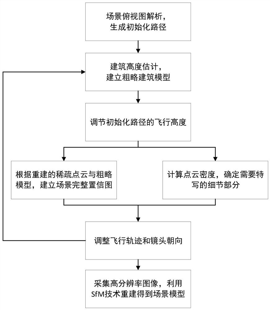
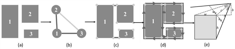
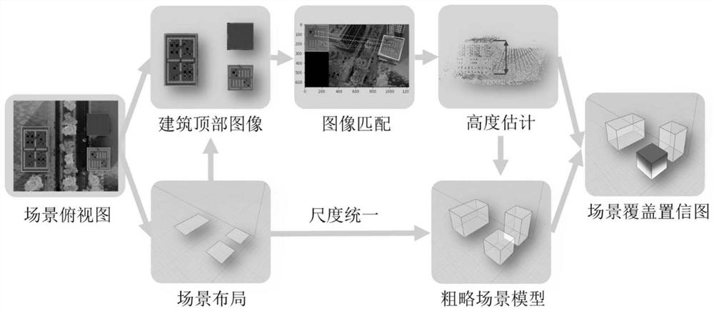
[0037] Such as figure 1Shown, flow chart of the present invention. The overall goal of the present invention is to propose a real-time UAV path planning method for urban scene reconstruction, which can enable the UAV to optimize the flight path in real time during a flight, collect comprehensive and complete information to complete the three-dimensional reconstruction of the scene. The specific steps are: first analyze the top view of the scene, get the layout of the scene, and generate the initial flight path of the drone with the camera orientation; reconstruct the sparse point cloud of the building during the flight, estimate the height of the building according to the point cloud, and combine The obtained scene layout generates a rough scene model ...


PUM


Abstract

The present invention provides a UAV real-time path planning method for urban scene reconstruction, using the scene top view as prior information to generate the initial path of the UAV, and optimizing the initial path in real time during the flight to realize the three-dimensional urban scene reconstruction. It mainly includes four steps. Step 1: Analyze the top view of the scene, get the scene layout, and generate the initial path of the drone; Step 2: Reconstruct the sparse point cloud of the building during the flight process according to the initial path and estimate the height of the building, combined with the scene layout to generate Rough scene model, adjust the initial path height; Step 3: With the help of the rough scene model, sparse point cloud and UAV flight trajectory, get the scene coverage confidence map and the details that need close-up, and optimize the flight path in real time; Step 4: Get the height The resolution image is reconstructed to obtain a 3D model of the scene. The invention has feasibility, accuracy and versatility, and can be used in applications such as three-dimensional reconstruction and automatic surveying and mapping of cities.

Description

technical field [0001] The invention relates to a real-time path planning method for UAVs used for urban scene reconstruction. The UAV initial flight trajectory is generated by using the top view of the scene as prior information, and the initial trajectory is optimized in real time during the flight process. The image acquisition and three-dimensional modeling of the scene have certain effectiveness and versatility, and belong to the field of robot path planning and computer graphics. Background technique [0002] With the rise of "digital cities", the 3D reconstruction of urban scenes is becoming a current research hotspot. The construction of 3D models of urban scenes can be widely used in urban planning, urban supervision, urban image promotion, real estate development and other fields. However, because the urban scene environment is relatively complex and the scale is relatively large, 3D reconstruction is also quite difficult. Because drones can collect data in the ai...

Claims


Application Information

Patent Timeline
Patent Type & Authority Patents(China)
IPC IPC(8): G01C21/20G05D1/10G06T17/10G06V10/764G06V20/17
CPCG01C21/20G05D1/101G06T17/10G06T7/73G06T7/579G06T2207/10032G06T2207/30241G06V20/176G06V20/10G06V10/513G06V10/757G06V20/17G06V10/764G06N3/045B64U2201/00B64U2101/30G06T7/80B64C39/024G06N3/04
Inventor 周彬匡麒吴进波赵沁平
Owner BEIHANG UNIV
Why Eureka
Try Eureka