Geohash matching-based vehicle code fitting method and system

A car code and vehicle technology, which is applied in the field of car code fitting methods and systems based on geohash matching, can solve problems such as inability to accurately determine and track criminal suspects, and achieve a solution that reduces the amount of calculation, facilitates tracking, and improves calculation efficiency. Effect

Active Publication Date: 2020-03-17
HANGZHOU SANHUI DIGITAL INFORMATION TECH
View PDF6 Cites 10 Cited by
  • Summary
  • Abstract
  • Description
  • Claims
  • Application Information

AI Technical Summary

Problems solved by technology

[0004] When using this scheme for public security prevention and control or case detection, it is often impossible to accurately determine and track the criminal suspect because the suspect forges the license plate number or the criminal suspect uses other people's vehicles, so further improvements to the existing technology are needed

Method used


Image

  • Geohash matching-based vehicle code fitting method and system
  • Geohash matching-based vehicle code fitting method and system
  • Geohash matching-based vehicle code fitting method and system

Examples


Embodiment 1

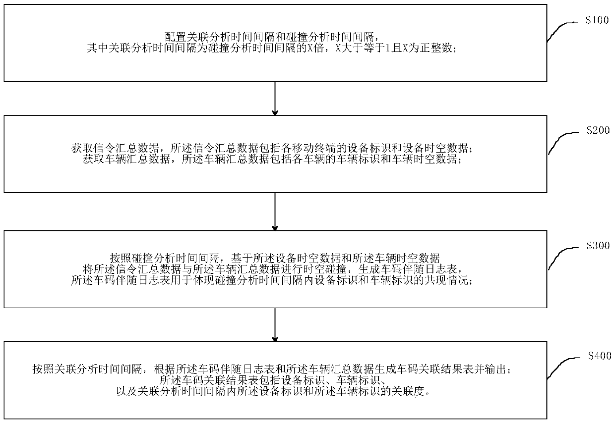
[0066] Embodiment 1, a kind of car code fitting method based on geohash matching, such as figure 1 shown, including the following steps:

[0067] S100, configure the correlation analysis time interval and the collision analysis time interval, wherein the correlation analysis time interval is X times the collision analysis time interval, X is greater than or equal to 1 and X is a positive integer;

[0068] S200. Obtain signaling summary data, where the signaling summary data includes device identification and device spatiotemporal data of each mobile terminal; acquire bayonet summary data, where the bayonet summary data includes vehicle identification and vehicle spatiotemporal data of each vehicle;

[0069] In this embodiment, the bayonet summary data can be grouped according to the license plate, and the vehicle summary table can be obtained by summarizing, and correlation analysis can be performed based on the vehicle summary table. S300. According to the collision analysis...

Embodiment 2

[0132] Embodiment 2, on the basis of embodiment 1, increase data elimination step, all the other are equal to embodiment 1;

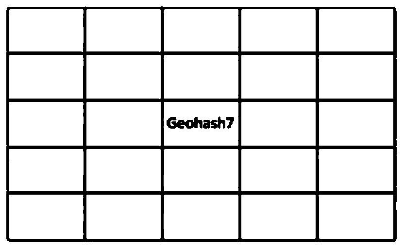
[0133] The geohash encoding described in the present embodiment comprises a first encoded value and a second encoded value, and the string length of the first encoded value is greater than the second encoded value;

[0134] In this embodiment, the string length of the first encoded value is 7, and the string length of the second encoded value is 6.

[0135] In this embodiment, the first code value is used for collision analysis to generate a vehicle code accompanying log table, and the second code value is used for correlation analysis to calculate the degree of correlation between the license plate mark and the device mark.

[0136] At this time, since the string length of the first code value is greater than the length of the second code value, as compared with the time-space collision using the second code, the number of combinations of the co-occurr...

Embodiment 3

[0156] Embodiment 3, a car code fitting system based on geohash matching, such as Figure 5 As shown, it includes an information configuration unit 100, a data acquisition unit 200, a collision analysis unit 300 and an association analysis unit 400

[0157] The information configuration unit 100 is used to configure the correlation analysis time interval and the collision analysis time interval, wherein the correlation analysis time interval is X times the collision analysis time interval, X is greater than or equal to 1 and X is a positive integer;

[0158] The data acquisition unit 200 is used to acquire signaling summary data, the signaling summary data including the equipment identification and equipment spatio-temporal data of each mobile terminal; also used to acquire checkpoint summary data, the checkpoint summary data including the Vehicle identification and vehicle spatio-temporal data;

[0159] The collision analysis unit 300 is configured to perform time-space coll...


PUM


Abstract

The invention discloses a geohash matching-based vehicle code fitting method and system. The geohash matching-based vehicle code fitting method comprises the following steps of configuring an association analysis time interval and a collision analysis time interval; acquiring signaling summary data, wherein the signaling summary data comprises equipment identifiers and equipment spatio-temporal data of the mobile terminals; acquiring checkpoint summary data, wherein the checkpoint summary data comprises vehicle identifiers and vehicle spatio-temporal data of vehicles; according to a collisionanalysis time interval, performing space-time collision on the signaling summary data and the gate summary data based on the equipment space-time data and the vehicle space-time data to generate a vehicle code accompanying log table; and according to the association analysis time interval, generating a vehicle code association result table according to the vehicle code accompanying log table and the bayonet summary data, and outputting the vehicle code association result table. According to the method, the license plate number and the mobile phone number can be fitted, the fitting accuracy ishigh, and the requirement for associated positioning of the vehicle and the mobile phone number at present is met.

Description

technical field [0001] The invention relates to the field of security prevention and control, in particular to a geohash-based car code fitting method and system. Background technique [0002] The GeoHash algorithm is an address encoding method that can encode two-dimensional spatial latitude and longitude data into a string, each string represents a rectangular area, and the length of the string corresponds to the range and accuracy of the rectangular area it represents. [0003] Currently, the target vehicle can only be tracked and monitored based on the license plate number and the checkpoint data collected by each checkpoint. A road traffic on-site monitoring system that photographs, records and processes motor vehicles at the checkpoint, and the data obtained from the monitoring is used as checkpoint data. [0004] When using this solution for public security prevention and control or case detection, it is often impossible to accurately determine and track the criminal...

Claims


Application Information

Patent Timeline
Patent Type & Authority Applications(China)
IPC IPC(8): G06F16/22G06F16/2458G06F16/28
CPCG06F16/2474G06F16/2282G06F16/284Y02D30/70
Inventor 张静丁敬安宣鑫乐
Owner HANGZHOU SANHUI DIGITAL INFORMATION TECH
Why Eureka
Try Eureka