Land cover change monitoring method, system and device and storage medium

A land cover and change monitoring technology, applied in the field of geographic information technology, can solve the problems of heavy workload, limited quality of change monitoring results, low technical level of interpreters, low efficiency, etc., achieve detailed analysis results, improve monitoring resolution and monitor efficiency effect

Active Publication Date: 2020-03-27
广东国地规划科技股份有限公司 +1
View PDF6 Cites 4 Cited by
  • Summary
  • Abstract
  • Description
  • Claims
  • Application Information

AI Technical Summary

Problems solved by technology

At present, remote sensing images are widely used in land cover change monitoring due to their short acquisition time and wide coverage. However, they are limited by traditional monitoring methods. In terms of monitoring methods, traditional monitoring methods mainly use manual visual interpretation , not only the workload is heavy and the efficiency is low, but also the quality of change monitoring results is limited by the technical level of the interpreters

Method used


Image

  • Land cover change monitoring method, system and device and storage medium
  • Land cover change monitoring method, system and device and storage medium
  • Land cover change monitoring method, system and device and storage medium

Examples


Embodiment Construction

[0056] The specific embodiment of the present invention will be further described below in conjunction with accompanying drawing:

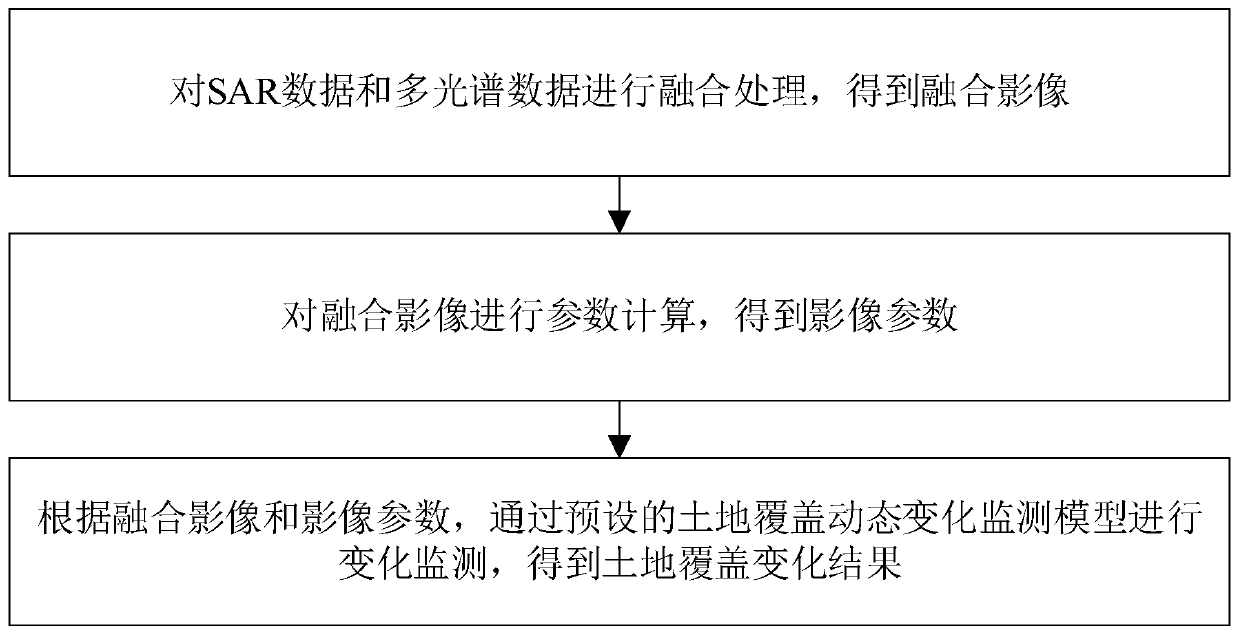
[0057] refer to figure 1 , a method for monitoring land cover change is provided in the present embodiment, comprising the following steps:

[0058] S1. Perform fusion processing on SAR data and multispectral data to obtain a fusion image;

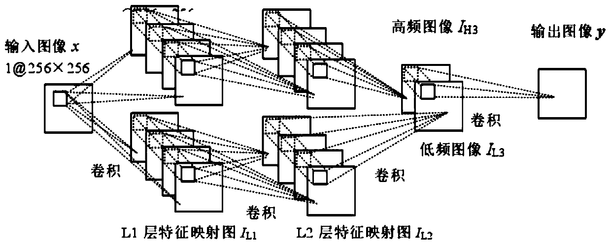
[0059] In this embodiment, when monitoring is required, the SAR data and multispectral data within the land cover change monitoring time period (in years) shall be obtained first, and geocoding, filtering and denoising, unified coordinates, unified resolution, and denoising shall be performed. Data preprocessing work such as cloud processing and calculation of normalized vegetation index; then the preprocessed data is trained through the preset deep stacked convolutional neural network, and the high and low frequency images are processed using the trained deep stacked convolutional neural network Decompositi...


PUM


Abstract

The invention discloses a land cover change monitoring method, system and device and a storage medium, and the method comprises the steps: fusing SAR data and multispectral data to acquire obtaining afusion image; performing parameter calculation on a fused image to obtain image parameters; and performing change monitoring through a preset land cover dynamic change monitoring model according to the fused image and the image parameters to obtain a land cover change result. The SAR data and the multispectral data are fused, the fused image machine is subjected to change monitoring through the land cover dynamic change monitoring model, all-weather characteristics and texture characteristics can be obviously combined, spectral characteristics can also be combined, the analysis effect is finer, and the monitoring resolution and the monitoring efficiency are greatly improved. The invention can be widely applied to the field of land monitoring.

Description

technical field [0001] The invention relates to the technical field of geographic information technology, in particular to a land cover change monitoring method, system, device and storage medium. Background technique [0002] Land cover change monitoring is the process of determining the change monitoring of land cover objects in the same spatial area and spatial phenomena observed at different times, and extracting and describing object changes over time based on geographic information data or remote sensing images in different periods. The country's land policy and land measures must rely on timely, effective and accurate land data, which puts forward the requirement of dynamic change monitoring for the management of land use status. At present, in daily land management, management departments mainly use reports from lower-level departments, reports from land users, or registration data to passively learn about changes, lacking initiative. At present, remote sensing imag...

Claims


Application Information

Patent Timeline
Patent Type & Authority Applications(China)
IPC IPC(8): G06T7/00G06T7/33G06T5/50
CPCG06T5/50G06T7/0002G06T2207/10032G06T2207/10036G06T2207/20081G06T2207/20084G06T2207/20221G06T2207/30184G06T7/33
Inventor 张鸿辉罗伟玲吴灿熊元康洪良张恒崔学森
Owner 广东国地规划科技股份有限公司
Why Eureka
Try Eureka