Automatic paving method based on laser scanning and satellite positioning

A satellite positioning and laser scanning technology, used in roads, road repair, roads, etc., can solve the problems of difficulty in realizing multi-machine joint paving, low level of automatic control of road paving, and low control accuracy, and achieve multi-machine joint paving. , Improve the level of automation control, the effect of high control accuracy

Inactive Publication Date: 2020-04-10
HENAN HIGHWAY ENG GROUP
View PDF4 Cites 11 Cited by
  • Summary
  • Abstract
  • Description
  • Claims
  • Application Information

AI Technical Summary

Problems solved by technology

[0003] The technical problem mainly solved by the present invention is to provide an automatic paving method based on laser scanning and satellite positioning, which solves the problems of low automatic control level, low control precision and difficulty in realizing multi-machine paving in the prior art.

Method used


Image

  • Automatic paving method based on laser scanning and satellite positioning
  • Automatic paving method based on laser scanning and satellite positioning
  • Automatic paving method based on laser scanning and satellite positioning

Examples


Embodiment Construction

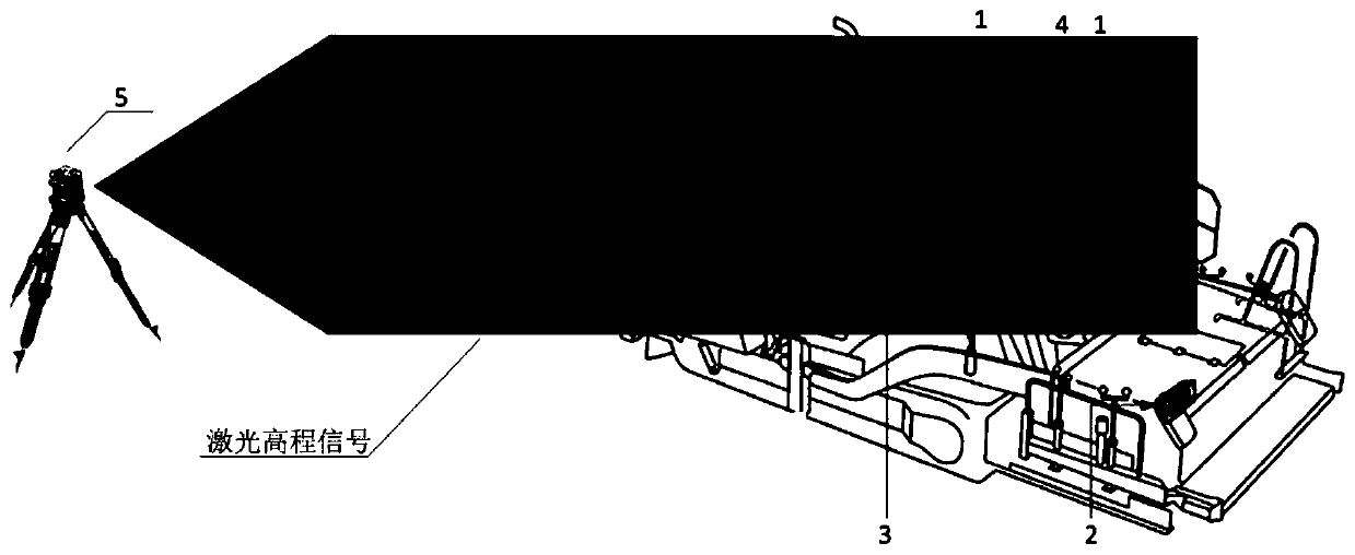
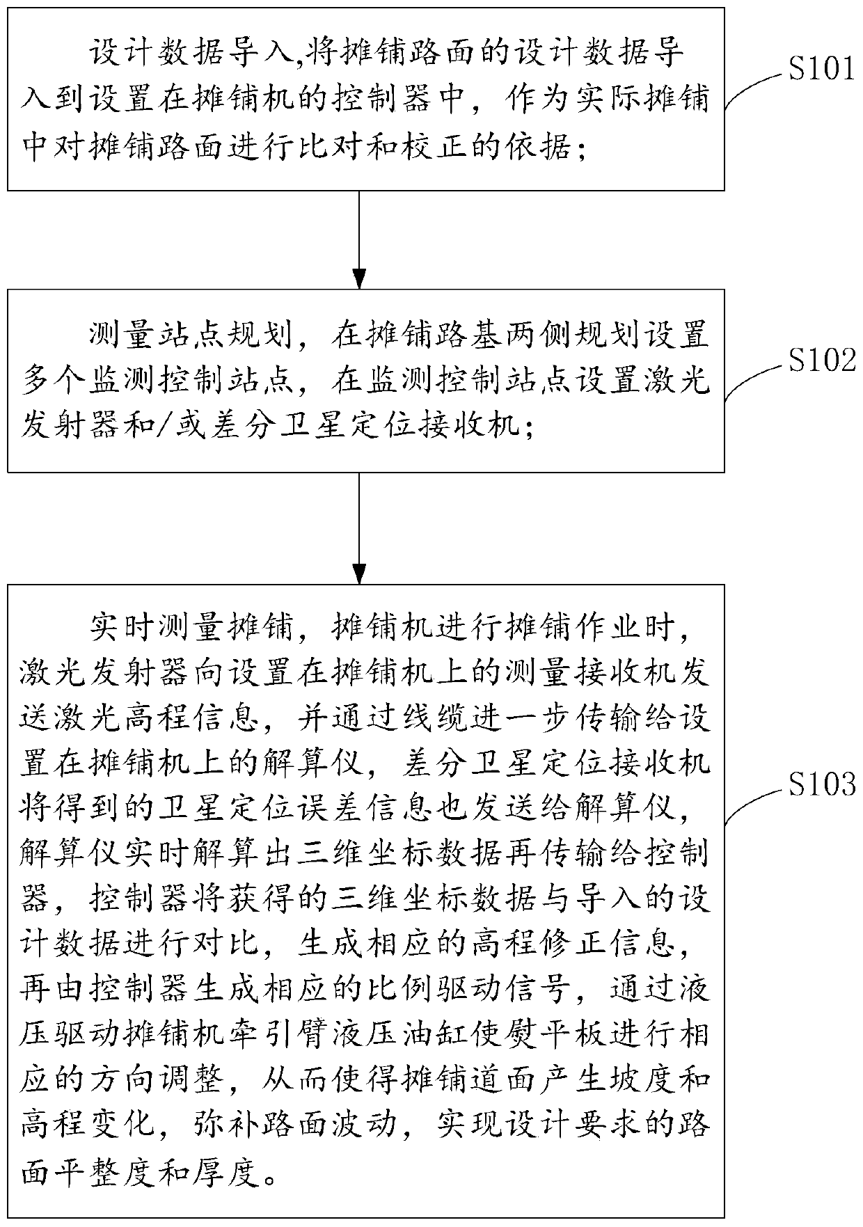
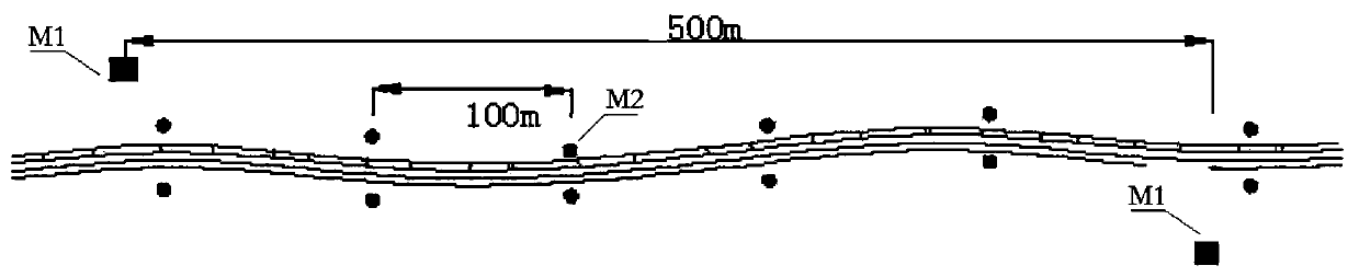
[0021] In order to facilitate the understanding of the present invention, the present invention will be described in more detail below in conjunction with the accompanying drawings and specific embodiments. Preferred embodiments of the invention are shown in the accompanying drawings. However, the present invention can be implemented in many different forms and is not limited to the embodiments described in this specification. On the contrary, these embodiments are provided to make the understanding of the disclosure of the present invention more thorough and comprehensive.

[0022] It should be noted that, unless otherwise defined, all technical and scientific terms used in this specification have the same meaning as commonly understood by those skilled in the technical field of the present invention. Terms used in the description of the present invention are only for the purpose of describing specific embodiments, and are not used to limit the present invention. The term "...


PUM


Abstract

The invention discloses an automatic paving method based on laser scanning and satellite positioning. The method comprises the following steps: importing design data: importing the design data of a paving pavement into a controller of a paver, and taking the design data as a basis for the comparison and correction of the paving pavement in actual paving; planning measurement stations: planning a plurality of monitoring control stations at two sides of a paving roadbed, and arranging laser emitters and/or differential satellite positioning receivers at the monitoring control stations; and performing real-time measurement paving: when the paver is used for paving operation, sending information to a resolver by the laser emitters and the differential satellite positioning receivers, transmiting the information to the controller by the resolver, and adjusting the direction of a screed correspondingly by the controller, so that the paving pavement generates gradient and elevation changes, pavement fluctuation is made up, and the pavement flatness and thickness required by design are achieved. The automatic control level of pavement paving is improved, the control precision is high, andmulti-machine joint paving is realized.

Description

technical field [0001] The invention relates to the field of foundation paving, in particular to an automatic paving method based on laser scanning and satellite positioning. Background technique [0002] In the prior art, roadbed paving mostly uses slipper sensors and sonar sensors to track the Luliang or datum line erected by surveyors for on-site construction to realize the control of paving thickness and smoothness. During construction, many on-site personnel are required to carry out benchmarking During the erection and pavement pre- and post-measurement work, monitoring and control cannot be implemented during the paving process, and rework often occurs due to incorrect benchmark setting. On-site coordination is time-consuming and labor-intensive, and the accuracy of paving is also difficult to achieve high standards , especially in the paving construction of expressway pavement and airport pavement with large roadside width and long distance. Contents of the inventi...

Claims


Application Information

Patent Timeline
Patent Type & Authority Applications(China)
IPC IPC(8): E01C23/01E01C19/48
CPCE01C19/4866E01C23/01
Inventor 高涛王方涛牛奇才杨宏永宋群生郑磊磊邓振江刘泽华庄亚东荆纪红马娟左思程超杰张建岗朱源张静文聂宇李本波
Owner HENAN HIGHWAY ENG GROUP
Why Eureka
Try Eureka