Three-dimensional GIS line selection design analysis method for urban rail transit

A technology of urban rail transit and design analysis, which is applied in the field of urban rail transit 3D GIS route selection design and analysis, which can solve the problems of insufficient expression support, low design coordination efficiency, and inability to solve the problems of statistical analysis of the impact of route selection design, etc., to achieve enhanced rendering effect , ensure high efficiency and shorten the 3D modeling cycle

Inactive Publication Date: 2020-04-10
SOUTHWEST JIAOTONG UNIV +1
View PDF5 Cites 4 Cited by
  • Summary
  • Abstract
  • Description
  • Claims
  • Application Information

AI Technical Summary

Problems solved by technology

At present, the route design mostly relies on CAD two-dimensional drawing to complete the design. The geographical environment information expressed by plane lines and words must be manually identified piece by piece, and the relationship indicators between the route plan and environmental information can only be completed by manual measurement. , the design coordination efficiency is extremely low
The latest development of the BIM system has supported the design of traffic engineering routes, but the main goal of the related systems is to complete the three-dimensional visualization of terrain

Method used


Image

  • Three-dimensional GIS line selection design analysis method for urban rail transit
  • Three-dimensional GIS line selection design analysis method for urban rail transit
  • Three-dimensional GIS line selection design analysis method for urban rail transit

Examples


Embodiment 1

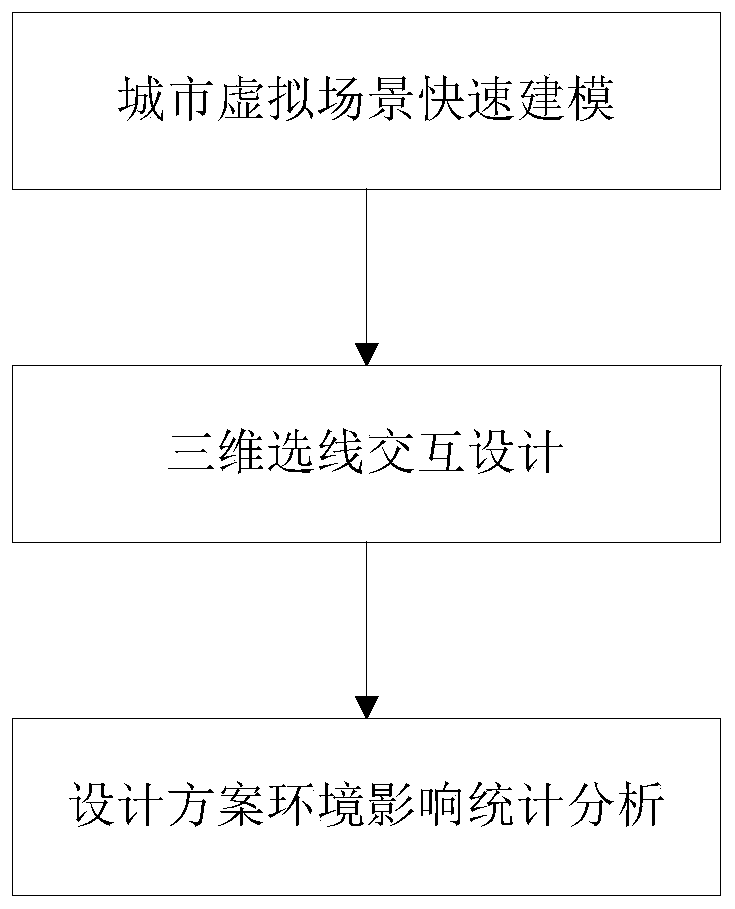
[0048] This embodiment proposes a design and analysis method for urban rail transit three-dimensional GIS line selection, such as figure 1 shown. The urban rail transit 3D GIS route selection design analysis method of this embodiment mainly includes three parts: rapid modeling of urban virtual scene, 3D route selection interactive design and design scheme environmental impact analysis:

[0049] Step 1, rapid modeling of urban virtual scene; specifically, in this embodiment, the 3D virtual scene is developed based on the osgEarth open source tool, which is the main interactive operation object of the whole system. In order to ensure that the 3D scene can meet the interaction design requirements in the case of integrating massive information, the system adopts four technical measures:

[0050] (1) Large-scale high-precision raster data and vector data are superimposed to form a basic 3D virtual scene. Imagery and elevation raster data are tiled and loaded into the virtual scen...

Embodiment 2

[0069] The present embodiment adopts the analysis method that above-mentioned embodiment proposes to carry out concrete design, and the process is as follows:

[0070] 1. Acquisition and conversion of survey data

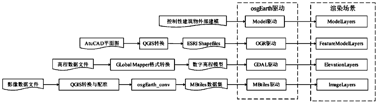
[0071] Large-scale urban images and elevation raster format data can be obtained through photogrammetry or remote sensing satellites. Local high-precision elevation data can be extracted from electronic topographic maps, and then converted into raster by Global Mapper. If the raster data is inconsistent with the city coordinate system, use QGIS for reprojection and correction. Use the osgearth_conv command provided by osgEarth to convert large-scale high-precision raster data into hierarchical tile data in mbtiles format. Use the QGIS tool to convert the road network, housing, line network, pipeline, pile foundation, land use planning and other data in DWG format into shapefile format files, and assign object attribute information. Such as figure 2 shown.

[00...


PUM


Abstract

The invention discloses a three-dimensional GIS line selection design analysis method for urban rail transit. The method comprises the following steps: 1, establishing an urban three-dimensional virtual scene model; 2, performing three-dimensional line selection interactive design based on the urban three-dimensional virtual scene model, including line position plane design, line position verticalsection design and spatial line position dynamic fitting; 3, performing engineering environment influence statistical analysis based on the urban three-dimensional virtual scene model and the designed urban rail transit line position. According to the method, a virtual city environment can be dynamically and efficiently constructed and browsed on the basis of integrating massive geographic information, a diversified scheme interaction design method in a three-dimensional scene is provided for rail transit line selection, and the method is compatible with a space analysis function to provide various statistical analysis data for line scheme decision making.

Description

technical field [0001] The invention relates to rapid modeling of virtual scenes of urban natural environment, three-dimensional interactive design of rail transit lines, and environmental impact analysis method of line schemes, in particular to a three-dimensional GIS line selection design analysis method of urban rail transit. Background technique [0002] The line position is the reference baseline of the rail transit engineering structure, and the line selection design work is to design the line position according to certain line standards, and analyze the relationship between the engineering structure and the environment. The understanding, analysis, evaluation and decision-making of various project participants on the line plan is crucial to promote the construction of rail transit projects, and the rapid identification of the geographical environment, as well as the statistical analysis of the relationship between the line plan and the environment are the basic conditi...

Claims


Application Information

Patent Timeline
IPC IPC(8): G06F30/13G06F30/12G06F30/20
Inventor 杨冬营易思蓉
Owner SOUTHWEST JIAOTONG UNIV
Why Eureka
Try Eureka