Method for carrying out aquatic vegetation annual change statistics by utilizing unmanned aerial vehicle and multispectral satellite image

A technology of satellite images and aquatic vegetation, which is applied in the fields of UAV and multispectral satellite image statistics, can solve the problems of high cost and long time consumption, and achieve the effects of high timeliness, low labor cost and fast efficiency

Active Publication Date: 2020-04-21
昆明市滇池高原湖泊研究院 +1
View PDF25 Cites 8 Cited by
  • Summary
  • Abstract
  • Description
  • Claims
  • Application Information

AI Technical Summary

Problems solved by technology

[0004] The purpose of the present invention is to provide a method for the annual change statistics of aquatic vegetation by unmanned aerial vehicles and multi-spectral satellite images, so as to solve the problems of high cost and long time consumption of the existing aquatic vegetation monitoring methods proposed in the above-mentioned background technology

Method used


Image

  • Method for carrying out aquatic vegetation annual change statistics by utilizing unmanned aerial vehicle and multispectral satellite image
  • Method for carrying out aquatic vegetation annual change statistics by utilizing unmanned aerial vehicle and multispectral satellite image
  • Method for carrying out aquatic vegetation annual change statistics by utilizing unmanned aerial vehicle and multispectral satellite image

Examples


Embodiment

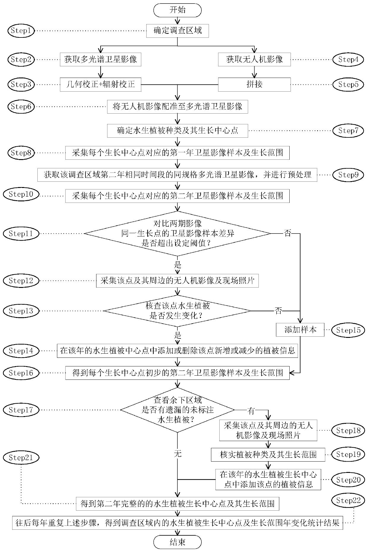
[0029] Embodiment: UAV and multi-spectral satellite images carry out the statistical method of lakeshore and lakeside aquatic vegetation annual change and include the following steps: detailed step flow chart reference figure 1 shown;

[0030] Step1: Determine the survey area. Generally, the survey area is distributed in a belt shape, and the main area is the lakeshore and lakeside.

[0031] Step2: To obtain multispectral satellite images, the resolution is required to be better than 0.5 meters, and there are at least four bands of red, green, blue, and near-infrared.

[0032] Step3: Geometric correction and radiometric correction. Preprocess the acquired multi-spectral satellite images to make them have accurate geographic coordinates and spectral information.

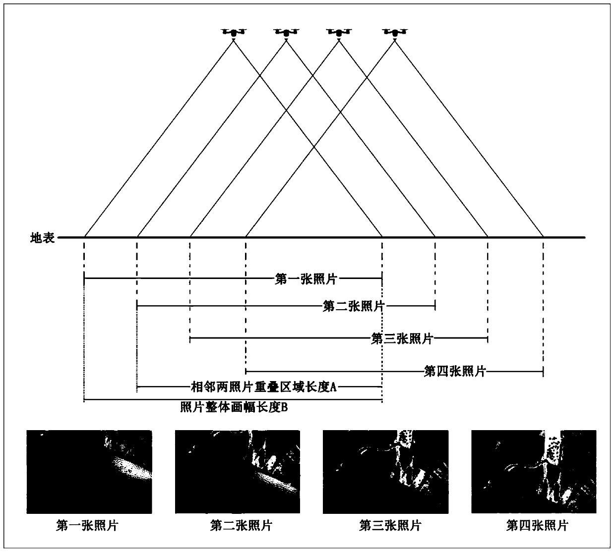
[0033] Step4: Obtain drone images. During the time period adjacent to the acquisition time of the satellite image, use the UAV mounted with the gimbal and the camera to fly the lakeside and the lakeshore according ...


PUM


Abstract

The invention discloses a method for carrying out aquatic vegetation annual change statistics by utilizing an unmanned aerial vehicle and a multispectral satellite image. The method comprises the following steps: acquiring multispectral satellite images of an investigation area, preprocessing the images, processing pictures acquired by the unmanned aerial vehicle to obtain an orthoimage, and registering the orthoimage to the preprocessed multispectral satellite image; carrying out aquatic vegetation classification by using the multispectral image and the registered orthoimage; marking aquaticvegetation types in the investigation area on the multispectral satellite images; acquiring satellite images of the same technical specification in the same time period of the second year, and preprocessing the satellite images; registering the multispectral satellite images obtained in the second year with the multispectral satellite images obtained in the first year; comparing the difference between the samples obtained by each aquatic vegetation marking point, and updating a marking point sample library according to the difference; and repeatedly collecting every year to obtain a statistical result of the annual change conditions of the aquatic vegetation.

Description

technical field [0001] The invention relates to the technical field of statistics of unmanned aerial vehicles and multispectral satellite images, in particular to a method for annual change statistics of aquatic vegetation by using unmanned aerial vehicles and multispectral satellite images. Background technique [0002] Aquatic vegetation: A type of vegetation that grows in water and is composed of aquatic plants. Due to the relatively consistent ecological conditions in the water body and the fluidity of the water, it is conducive to the extensive migration and spread of aquatic plants. Therefore, there are many species of aquatic plants, and there are also species in the world. In each natural zone, the types of aquatic plants are roughly the same. Among aquatic plants, there are simple types of higher plants and many lower plants. Aquatic vegetation plays a key role in maintaining a healthy lake ecosystem, and plays an important role in maintaining the structure and fu...

Claims


Application Information

Patent Timeline
Patent Type & Authority Applications(China)
IPC IPC(8): G06T7/00G06T7/10G06T7/136G06T7/30G06T7/70G06K9/46
CPCG06T7/0002G06T7/10G06T7/136G06T7/30G06T7/70G06T2207/10036G06T2207/30188G06T2207/30232G06V10/44
Inventor 潘珉王飞李杨李滨孔祥丰黄育红宋任彬施苏毅
Owner 昆明市滇池高原湖泊研究院
Why Eureka
Try Eureka