Navigation mark intelligent supervision system and method based on unmanned aerial vehicle

A monitoring system and unmanned aerial vehicle technology, applied in the field of data processing, can solve the problems of insufficient comprehensive navigation mark recognition, low accuracy of navigation mark recognition, and limited shooting range, etc., to achieve strong flexibility, improve the level of navigation mark supervision, and low supervision costs Effect

Inactive Publication Date: 2020-05-05
GUILIN UNIV OF AEROSPACE TECH
View PDF6 Cites 4 Cited by
  • Summary
  • Abstract
  • Description
  • Claims
  • Application Information

AI Technical Summary

Problems solved by technology

However, this method is quite expensive and requires regular maintenance of the camera device
In addition, due to the limited shooting range of the camera device, this method is not comprehensive enough for navigation mark recognition, making the accuracy of navigation mark recognition low

Method used


Image

  • Navigation mark intelligent supervision system and method based on unmanned aerial vehicle
  • Navigation mark intelligent supervision system and method based on unmanned aerial vehicle

Examples


Embodiment Construction

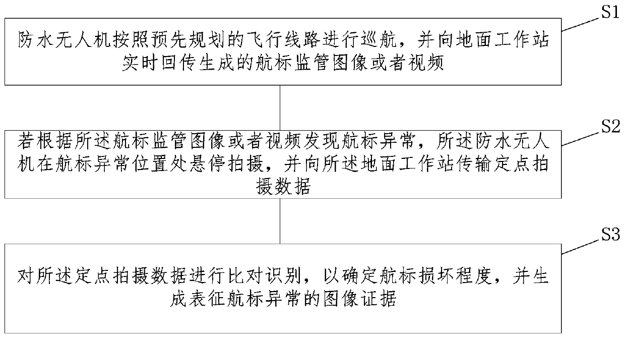
[0031] In order to enable those skilled in the art to better understand the technical solutions in the present application, the technical solutions in the embodiments of the present application will be clearly and completely described below in conjunction with the drawings in the embodiments of the present application. Obviously, the described The implementations are only some of the implementations of the present application, not all of them. Based on the implementation manners in this application, all other implementation manners obtained by persons of ordinary skill in the art without creative efforts shall fall within the scope of protection of this application.

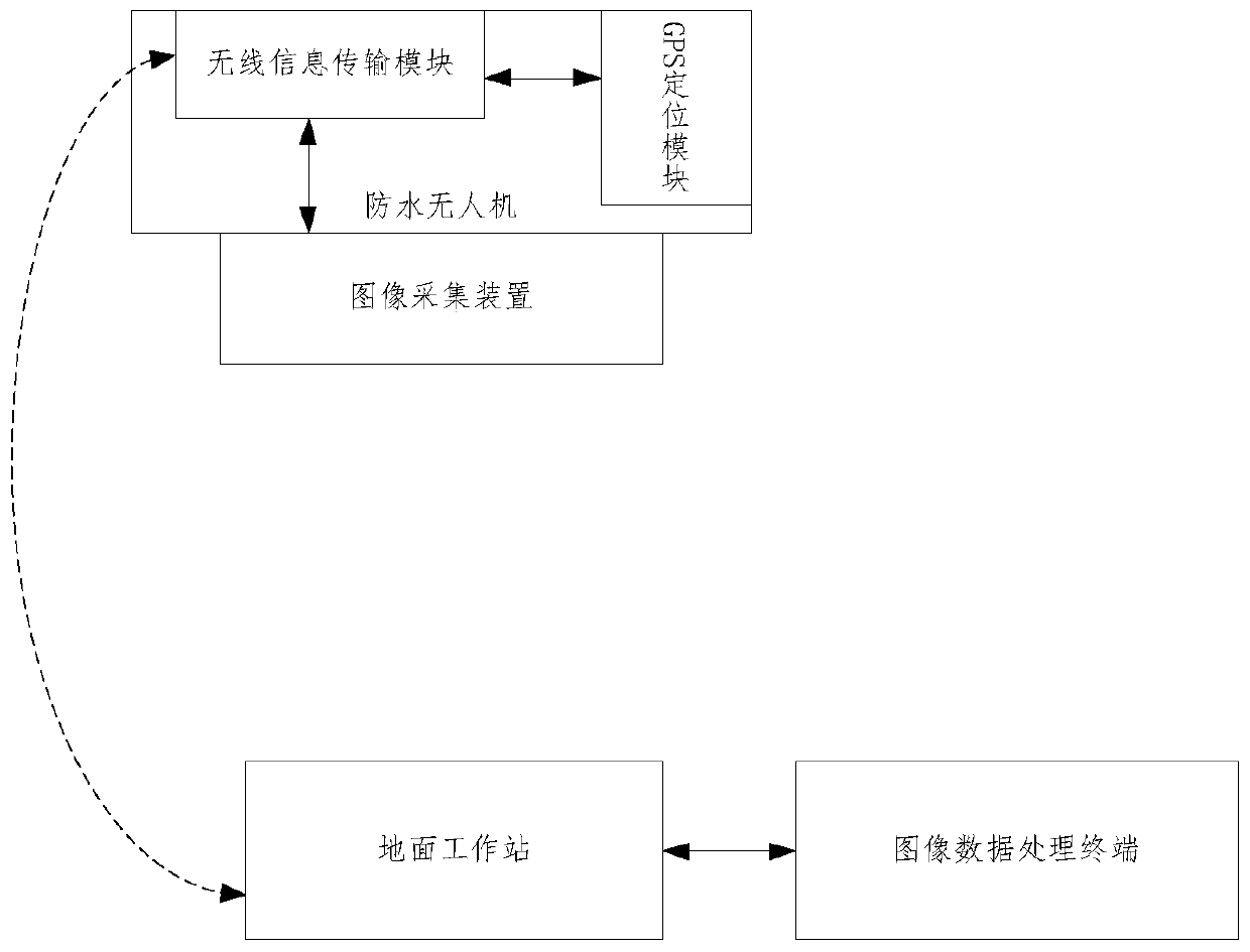
[0032] This application provides a UAV-based intelligent navigation system, please refer to figure 1 , the system includes a waterproof drone, an image acquisition device, a GPS positioning module, a ground workstation and an image data processing terminal, wherein:

[0033] The waterproof drone is wirelessly co...


PUM


Abstract

The embodiment of the invention relates to a navigation mark intelligent supervision system and method based on unmanned aerial vehicle. The system comprises a waterproof unmanned aerial vehicle, an image acquisition device, a GPS positioning module, a ground workstation and an image data processing terminal. The waterproof unmanned aerial vehicle flies or performs fixed-point inspection accordingto a pre-planned flight route. The image acquisition device is used for generating a navigation mark supervision image or video. The GPS positioning module is used for collecting longitude and latitude information corresponding to the navigation mark supervision image or video. The ground workstation is used for receiving navigation mark supervision images or videos and longitude and latitude information. The image data processing terminal is used for calling and displaying the navigation mark video pictures of the navigation mark distribution water area and comparing and analyzing the imagesor videos acquired by the image acquisition device so as to identify the damage degree of the navigation mark. According to the technical scheme provided by the invention, the navigation mark supervision accuracy can be improved while the cost is reduced.

Description

technical field [0001] This application relates to the technical field of data processing, and in particular to an intelligent supervision system and method for navigation aids based on drones. Background technique [0002] At present, in order to mark the direction of the channel, boundaries and obstructions, navigation marks are usually distributed on the waters. Aids to aid will be eroded to varying degrees over time. Eroded buoys can lead to ineffective water marking, which can pose a safety hazard. [0003] In view of this, it is necessary to regularly monitor the navigation mark, so as to identify the damaged navigation mark in time. At present, when supervising the navigation mark, multiple camera devices can be distributed along the water area, and the damaged navigation mark can be determined by analyzing the images captured by the camera devices. However, this method is quite expensive and requires regular maintenance of the camera device. In addition, due to t...

Claims


Application Information

Patent Timeline
Patent Type & Authority Applications(China)
IPC IPC(8): G01C11/00G01C11/02G01S19/14H04N7/18
CPCG01C11/00G01C11/02G01S19/14H04N7/18
Inventor 黄锐李昕恬诸伟杜春
Owner GUILIN UNIV OF AEROSPACE TECH
Why Eureka
Try Eureka