Mine geological disaster dynamic identification and monitoring method based on multi-source remote sensing data

A technology for geological disasters and remote sensing data, which is used in measurement devices, re-radiation of electromagnetic waves, radio wave measurement systems, etc.

Active Publication Date: 2020-05-12
CHINA UNIV OF GEOSCIENCES (BEIJING) +1
View PDF15 Cites 30 Cited by
  • Summary
  • Abstract
  • Description
  • Claims
  • Application Information

AI Technical Summary

Problems solved by technology

[0009] For this reason, the embodiment of the present invention provides a method for dynamic identification and monitoring of geological hazards in mines based on multi-source remote sensing data to solve the problem of inability to perform accurate dynamic identification and monitoring in the prior art due to insufficient existing technology

Method used


Image

  • Mine geological disaster dynamic identification and monitoring method based on multi-source remote sensing data
  • Mine geological disaster dynamic identification and monitoring method based on multi-source remote sensing data
  • Mine geological disaster dynamic identification and monitoring method based on multi-source remote sensing data

Examples


Embodiment

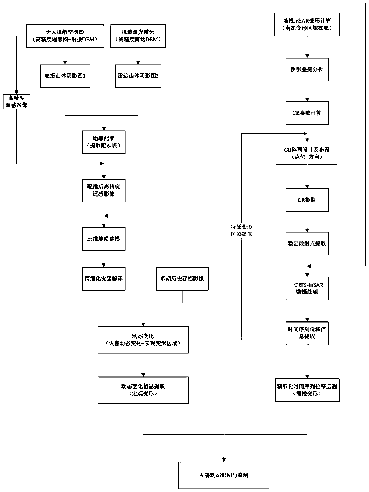
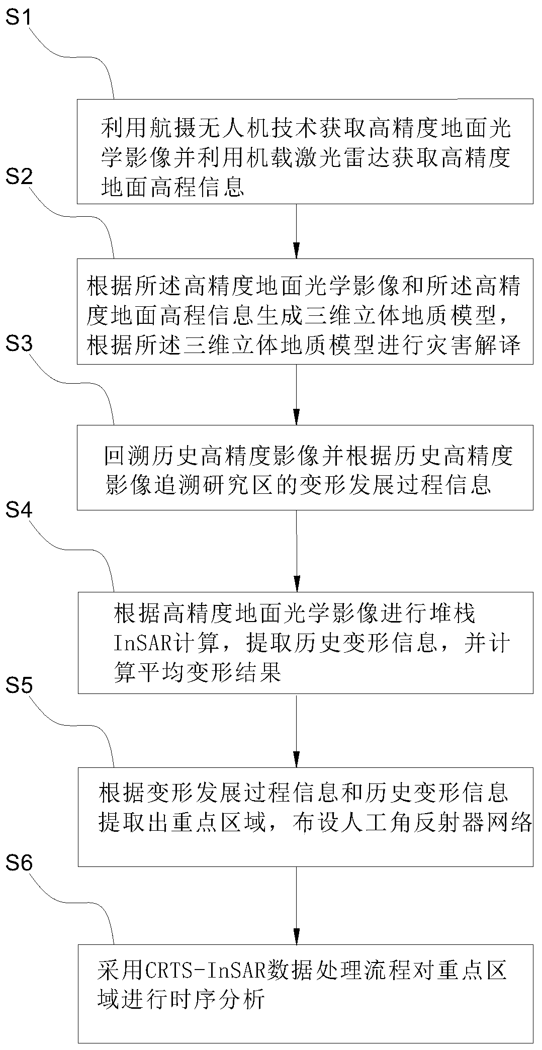
[0054] Embodiment: A method for dynamic identification and monitoring of mine geological hazards based on multi-source remote sensing data, such as figure 1 and figure 2 shown, including the following steps

[0055] S1: Use aerial photography UAV technology to obtain high-precision ground optical images and use airborne lidar to obtain high-precision ground elevation information;

[0056] Specifically: the workflow of obtaining high-precision ground optical images using aerial photography UAV technology is: outline the flight area, design the route, use the image-free UAV to perform flight tasks to obtain high-precision orthophoto images, and its data processing flow It is: flight overlap inspection-aerial triangulation calculation-intelligent adjustment-dem generation-orthorectification-dom generation-orthophoto stitching, with an accuracy of 0.05m-0.1m. The image-free control technology can obtain mm-level error flight data without relying on the ground control point netw...


PUM


Abstract

The embodiment of the invention discloses a mine geological disaster dynamic identification and monitoring method based on multi-source remote sensing data. An optical remote sensing technology, an unmanned aerial vehicle airborne laser radar technology, an artificial corner reflector technology and a satellite-borne synthetic aperture radar technology are fused; an airborne laser radar can effectively remove ground vegetation; an accurate deformation profile and a ground fracture steep ridge distribution condition are obtained; archived high-precision optical image data are utilized to comprehensively analyze and describe a deformation development history, high-resolution remote sensing image change detection and feature recognition are utilized to search disaster signs, the airborne laser radar is introduced to acquire high-precision dem data, and topographic effect influence in InSAR data processing is effectively removed; an artificial corner reflector array is arranged, the numberof coherent points in a key area is increased, the coherent point distribution is optimized, and the interference phase unwrapping effect is improved; a traditional time sequence InSAR data processing technology is optimized, and a high-precision time sequence deformation curve is obtained by using CR-InSAR.

Description

technical field [0001] Embodiments of the present invention relate to the technical field of mine geological disaster identification and monitoring, and in particular to a method for dynamic identification and monitoring of mine geological disasters based on multi-source remote sensing data. Background technique [0002] With the expansion and deepening of human activities, human activities are gradually replacing natural forces as the main reason affecting slope stability. The frequency of landslide disasters caused by human engineering activities such as mining, hydropower development, road construction and slope cutting has gradually increased, and the resulting loss of personnel and property has increased. Many catastrophic landslides occurred in the Table Mountain structural mountain with coal mining activities in the lower part. Many cases show that it is particularly important to carry out early identification and monitoring of mine geological disasters. [0003] Min...

Claims


Application Information

Patent Timeline
Patent Type & Authority Applications(China)
IPC IPC(8): G01S17/90G01C11/02G08B21/10
CPCG01C11/02G08B21/10
Inventor 朱怡飞姚鑫李凌婧周振凯任开瑀
Owner CHINA UNIV OF GEOSCIENCES (BEIJING)
Why Eureka
Try Eureka