
Rapid emergency monitoring system and method for landslide disasters along rivers

A technology for monitoring systems and disasters, applied in transmission systems, closed-circuit television systems, radio transmission systems, etc., can solve problems such as barrier lakes affecting shipping traffic, environment, financial resources, personnel losses, and difficulty in avoiding

Inactive Publication Date: 2020-05-26
CHONGQING JIAOTONG UNIVERSITY
View PDF12 Cites 5 Cited by
  • Summary
  • Abstract
  • Description
  • Claims
  • Application Information

AI Technical Summary

Problems solved by technology

[0002] Landslides are often caused in foothill areas. Even if the disaster does not spread to a very large area, the rocks will slide rapidly when the disaster occurs, and there is a great suddenness, so once encountered, it must be extremely difficult to avoid
In the event of bad weather, such as heavy rain, it will cause immeasurable destructive power, and even form a barrier lake that will seriously affect shipping traffic and cause immeasurable losses to the environment, financial resources, and personnel. Timely disaster monitoring and Emergency assistance is very important
[0003] Especially for landslides along the river, the disaster area is often unable to communicate with the outside world due to the blockage of roads and the breakdown of communication equipment in the affected area. Blocking and water pollution problems can cause hundreds of millions of losses every day, so in order to improve the emergency response speed and accuracy of landslide disasters, it is necessary for us to develop a safe, effective and accurate monitoring method for landslide disasters along the river

Method used


Image

  • Rapid emergency monitoring system and method for landslide disasters along rivers
  • Rapid emergency monitoring system and method for landslide disasters along rivers
  • Rapid emergency monitoring system and method for landslide disasters along rivers

Examples


Embodiment 1

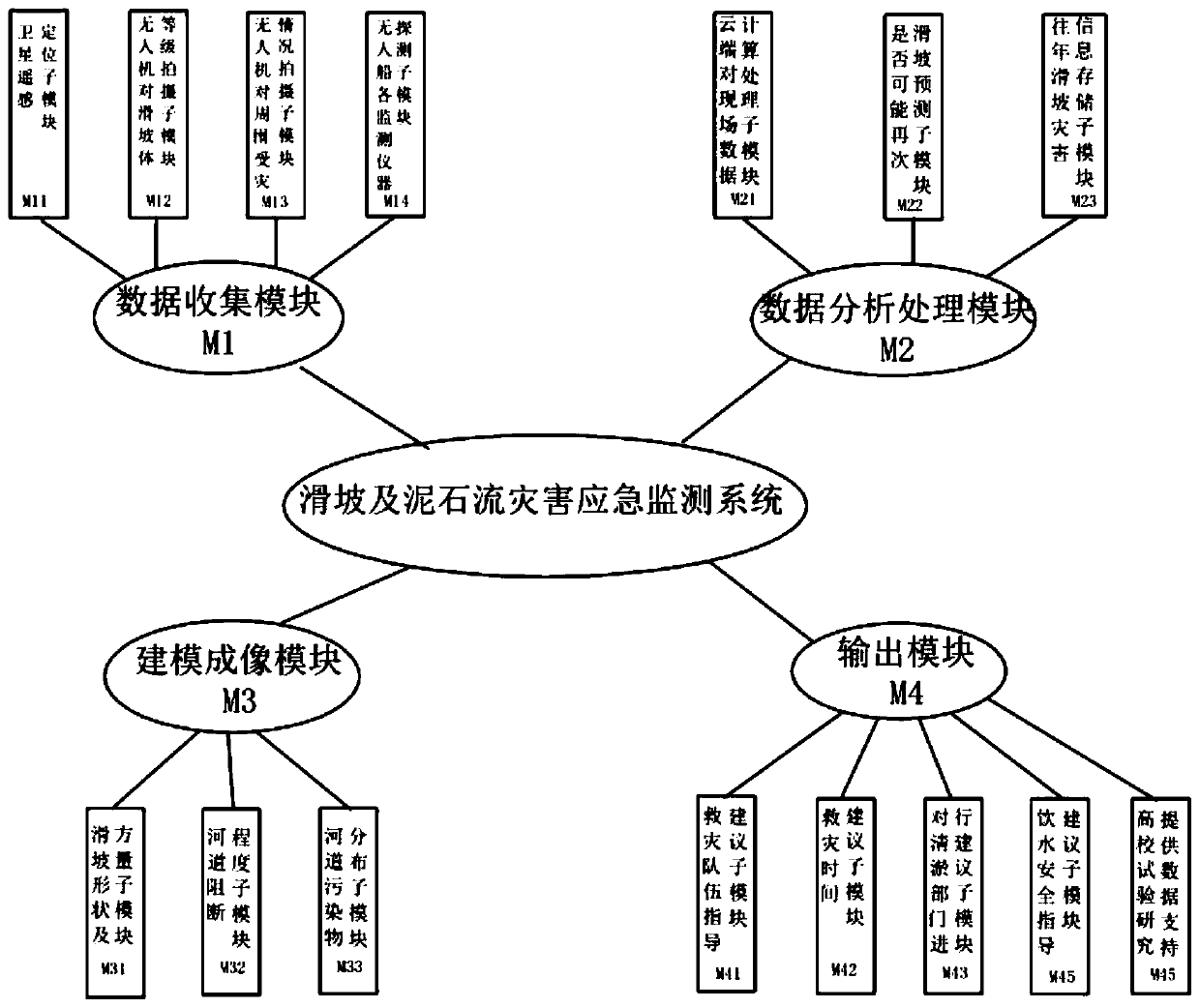
[0036] This embodiment discloses a rapid emergency monitoring system for landslide disasters along the river, including a data collection module M1, a data analysis and processing module M2 in the cloud database 5, a modeling and mapping module M3 and an output module M4.

[0037] see image 3 , the data collection module M1 includes a submodule M11, a submodule M12, a submodule M13 and a submodule M14.

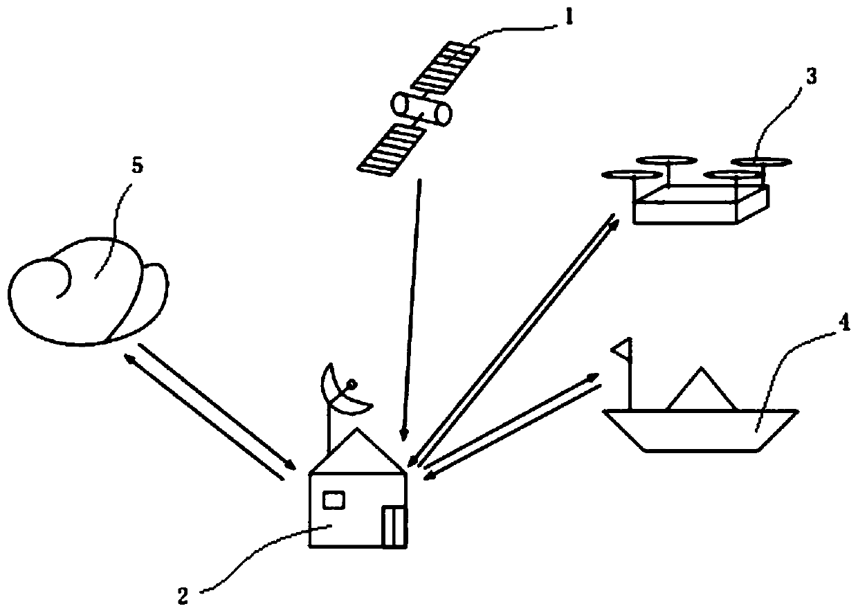
[0038] see figure 1 , the ground base station 2 is set up in the landslide section, and the ground base station 2 is equipped with a drone 3, an unmanned ship 4 and a satellite communication system. The satellite remote sensing 1 collects disaster coordinate information and disaster level information and stores them in the sub-module M11, and the sub-module M11 sends the information to the ground base station 2 through the satellite communication system.

[0039]The ground base station 2 sends the unmanned aerial vehicle 3 and the unmanned ship 4 to the disaster-stricken po...

Embodiment 2

[0046] Based on the monitoring system described in Embodiment 1, this embodiment discloses a method for rapid emergency monitoring of landslide disasters along the river, comprising the following steps:

[0047] 1) Set up the ground base station 2 near the landslide area according to geological exploration analysis. Wherein, the ground base station 2 is equipped with a drone 3, an unmanned ship 4 and a satellite communication system.

[0048] 2) The satellite remote sensing 1 locates the specific latitude and longitude coordinates of the disaster area, the satellite remote sensing 1 determines the size and level of the landslide, stores the coordinate information and disaster level information in the sub-module M11, and the sub-module M11 sends the information to the ground base station 2.

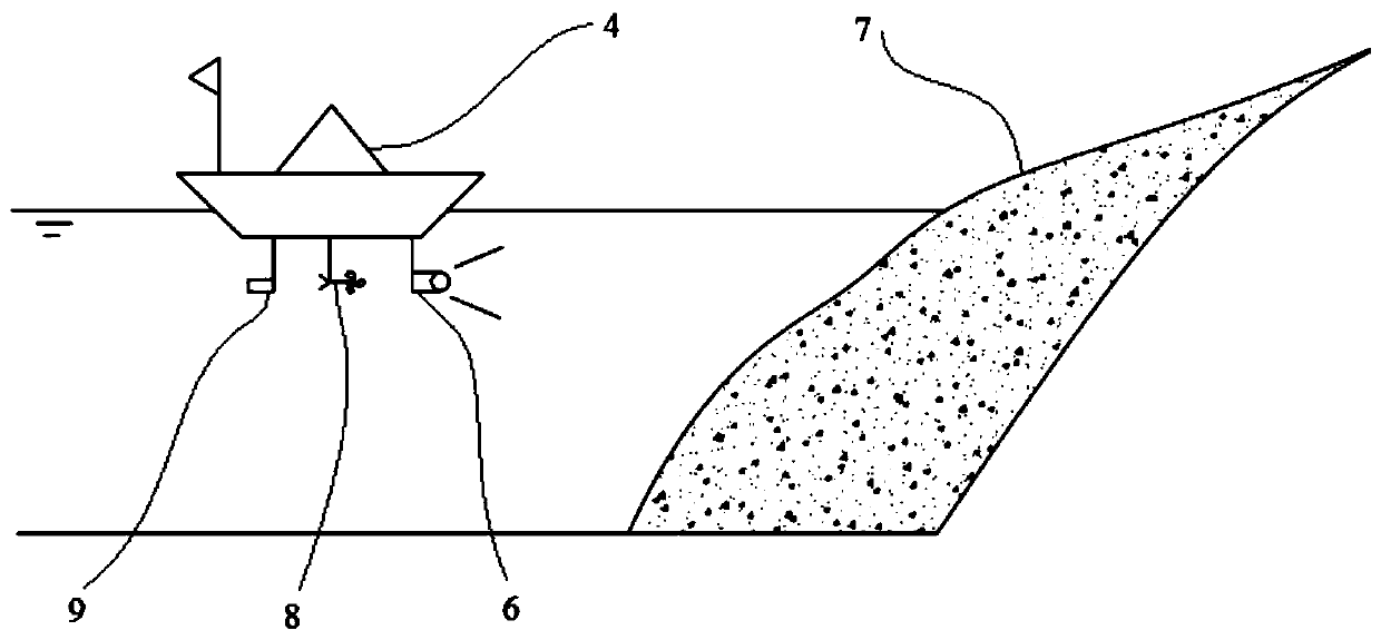
[0049] 3) The ground base station 2 sends the unmanned aerial vehicle 3 to the disaster-stricken point, and the high-definition camera carried by the unmanned aerial vehicle 3 shoots the d...


PUM


Abstract

The invention discloses a rapid emergency monitoring system and method for landslide disasters along rivers, and the method comprises the following steps: satellite remote sensing positioning is performed, and an instruction is sent to a ground base station disposed at an area nearby an easy landslide; a ground base station dispatches an unmanned aerial vehicle and an unmanned ship to a disastersite; a high-definition camera carried by an unmanned aerial vehicle and a high-low double-frequency ultrasonic detector, a current meter and a turbidity meter carried by an unmanned ship are used forcollecting original data of an affected river channel; data is sent to a cloud database for calculation; and a calculation result is fed back to the ground base station, the ground base station establishes two-dimensional and three-dimensional imaging models of landslide disaster forms, river channel blocking conditions and river channel pollutant distribution according to the result, original data and a processing result are stored in the cloud big data platform, and the processing result is sent to related departments for rapid disaster relief guidance. According to the invention, the problem that roads are blocked and communication equipment is paralyzed in disaster areas along rivers and cannot communicate with the outside is solved, landslide disasters along rivers can be quickly responded and monitored, and disaster relief reference is provided for related departments.

Description

technical field [0001] The invention relates to the technical field of landslide disaster treatment, in particular to a rapid emergency monitoring system and method for landslide disasters along a river. Background technique [0002] Landslides are often caused in foothill areas. Even if the disaster does not spread to a very large area, when the disaster occurs, the rocks will slide rapidly, and there is a great suddenness, so once encountered, it must be extremely difficult to avoid. In the event of bad weather, such as heavy rain, it will cause immeasurable destructive power, and even form a barrier lake that will seriously affect shipping traffic and cause immeasurable losses to the environment, financial resources, and personnel. Timely disaster monitoring and Emergency assistance is very important. [0003] Especially for landslides along the river, the disaster area is often unable to communicate with the outside world due to the blockage of roads and the breakdown o...

Claims


Application Information

Patent Timeline
IPC IPC(8): G08B21/10H04B7/185H04N7/18
CPCG08B21/10H04B7/18506H04B7/1851H04N7/185
Inventor 王平义田野王梅力韩林峰陈雅飞赵聪聪
Owner CHONGQING JIAOTONG UNIVERSITY
Learn More