Flood disaster assessment method, device and apparatus and computer storage medium

A flood and to-be-assessed technology, which is applied in the field of devices, flood damage assessment methods, equipment and computer storage media, can solve the problem that flood damage assessment cannot have both analysis speed and accuracy at the same time, and achieve the effect of improving accuracy

Pending Publication Date: 2020-06-09
CHENGDU UNIVERSITY OF TECHNOLOGY
View PDF10 Cites 1 Cited by
  • Summary
  • Abstract
  • Description
  • Claims
  • Application Information

AI Technical Summary

Problems solved by technology

[0006] In order to solve the problem that the existing flood damage assessment cannot have both analysis speed and accuracy, the purpose of the present invention is to provide a flood damage assessment method, device, and equipment that have both the rapidity of passive analysis and the accuracy of active analysis and computer storage media

Method used


Image

  • Flood disaster assessment method, device and apparatus and computer storage medium
  • Flood disaster assessment method, device and apparatus and computer storage medium
  • Flood disaster assessment method, device and apparatus and computer storage medium

Examples


Embodiment 1

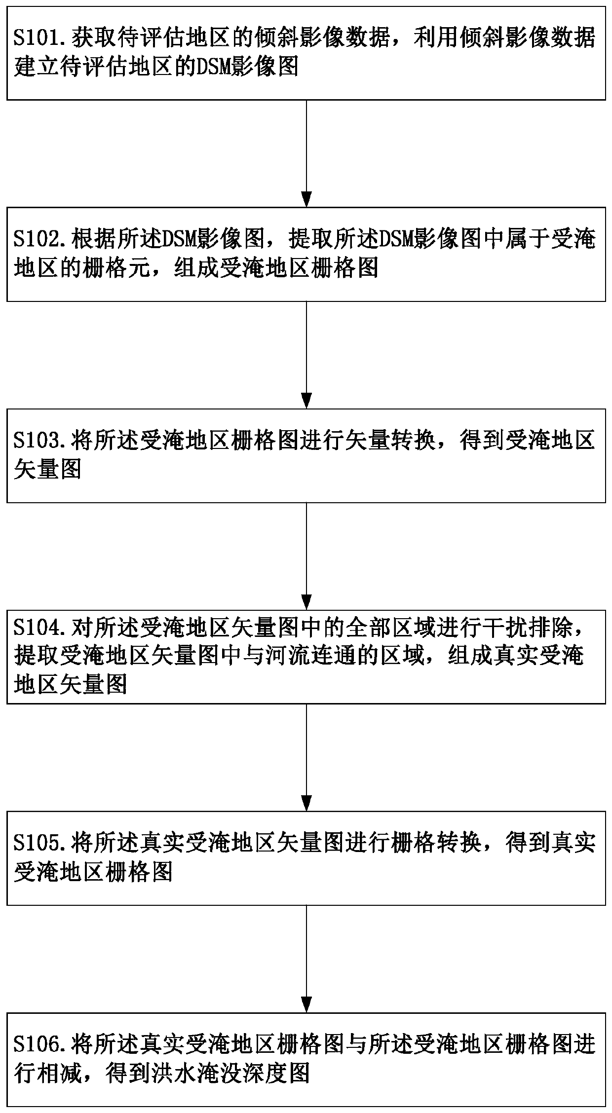
[0054] like Figure 1~2 As shown, the flood disaster assessment method provided in this embodiment includes the following steps:

[0055] S101. Obtain oblique image data of the region to be evaluated, and use the oblique image data to establish a DSM image map of the region to be evaluated.

[0056] Step S101 is to obtain the DSM image map of the area to be evaluated, DSM (Digital Surface Model, digital surface model) image Figure 1 This kind of data map is generated by clipping the data map according to the range of the map after being corrected by the pixel-by-pixel projection difference, and then mosaiced according to the influence. It can display the ground height of buildings, bridges and trees on the ground.

[0057] In this embodiment, the oblique image data of the area to be evaluated is used as the data basis to obtain the DSM image map of the area to be evaluated. The specific establishment method will be described in detail below.

[0058] At the same time, in thi...

Embodiment 2

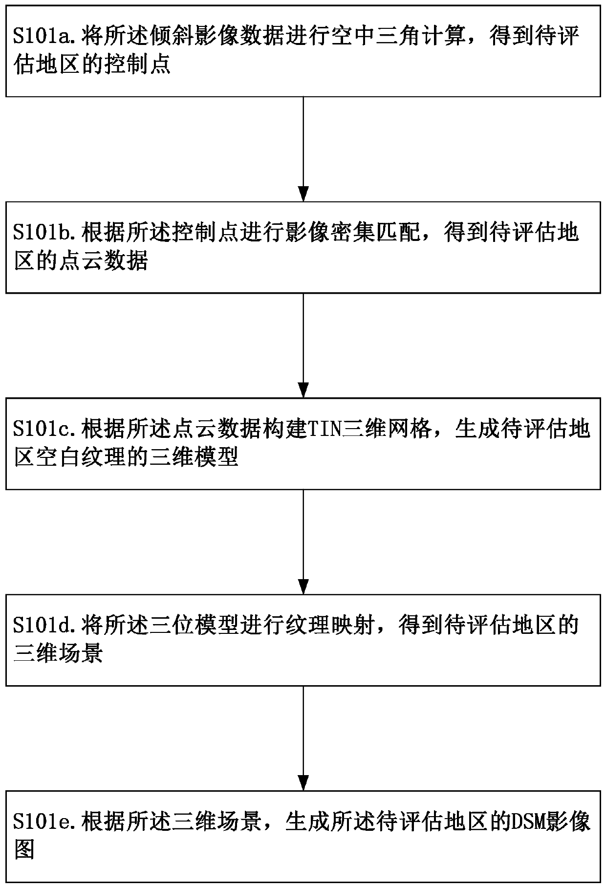
[0099] like figure 2 As shown, the present embodiment provides a specific implementation manner of specifically establishing a DSM image map, which specifically includes the following steps:

[0100] S101a. Perform aerial triangulation calculation on the oblique image data to obtain the control points of the area to be evaluated.

[0101] S101b. Perform dense image matching according to the control points to obtain point cloud data of the area to be evaluated.

[0102] S101c. Construct a TIN three-dimensional grid according to the point cloud data, and generate a three-dimensional model of the blank texture of the area to be evaluated.

[0103] S101d. Perform texture mapping on the three-dimensional model to obtain a three-dimensional scene of the region to be evaluated.

[0104] S101e. Generate a DSM image map of the region to be evaluated according to the three-dimensional scene.

[0105] In this embodiment, the oblique image data of the area to be evaluated is obtained ...

Embodiment 3

[0120] like image 3 As shown, this embodiment provides a device for implementing the method for assessing flood damage in Embodiment 1, including a DSM image generation module, a grid processing module, an interference elimination module, and a submerged water map calculation module.

[0121] The DSM image generation module is used to obtain oblique image data and generate a DSM image map of the area to be evaluated.

[0122] The grid processing module is communicatively connected to the DSM image generation module, and is used to obtain a grid map of the flooded area according to the DSM image map, and perform vector conversion on the grid map of the flooded area to obtain the flooded area Vector illustration.

[0123] The interference removal module is connected to the raster processing module by communication, and is used for removing interference on the vector map of the flooded area to obtain a real vector map of the flooded area.

[0124] The flooded water level map c...


PUM


Abstract

The invention discloses a flood disaster assessment method, device and apparatus and a computer storage medium. According to the method, firstly, a DSM image map of a region to be evaluated is established, a grid map of a flooded region is directly acquired from the DSM image map, vector conversion is performed on the grid map of the flooded area to obtain the vector map of the flooded area, the mode is equivalent to traditional passive analysis, and the flooded range of the area to be evaluated can be quickly obtained; meanwhile, the interference elimination of the vector diagram of the flooded area is also carried out. Only the area, connecting with the river, in the vector diagram of the flooded area is extracted, the extracted area serves as the vector diagram of the real flooded area,and the connectivity of the flooded area and flood spreading is considered in the step, so that the area which is not communicated with the river can be eliminated, and the accuracy of an analysis result is improved. Through the design, the evaluation method provided by the invention not only reserves the rapidity of passive analysis, but also has the accuracy of active analysis, and can quicklyand accurately obtain the flood inundation range.

Description

technical field [0001] The invention relates to the technical field of flood disaster assessment, in particular to a flood disaster assessment method, device, equipment and computer storage medium. Background technique [0002] As one of the 15 major natural disasters released by the United Nations and paid close attention to worldwide, flood disasters have the characteristics of large impact range, high frequency of occurrence, and large losses. For villages and towns in the river basin, if the embankment collapses, it will pose a huge threat to the safety of residents' lives and property, and seriously affect the economic development and ecological environment of the affected areas. Therefore, the flooding of villages The analysis is of great significance to the assessment of flood damage. [0003] At present, the impact characteristics and disaster assessment methods of flood disasters generally adopt two methods: active analysis and passive analysis. [0004] Active an...

Claims


Application Information

Patent Timeline
IPC IPC(8): G06T7/593G06T17/05G06T15/04
CPCG06T7/593G06T17/05G06T15/04G06T2207/10012G06T2207/20224G06T2207/30181Y02A10/40
Inventor 何朝阳肖金武巨能攀许强敖仪斌
Owner CHENGDU UNIVERSITY OF TECHNOLOGY
Why Eureka
Try Eureka