Community life circle space identification method and system, computer equipment and storage medium

A technology of space recognition and life circle, applied in the field of quantitative measurement of community life circle, which can solve the problems of technical difficulty in planning, lack of consideration, etc.

Active Publication Date: 2020-06-12
SOUTH CHINA UNIV OF TECH
View PDF3 Cites 6 Cited by
  • Summary
  • Abstract
  • Description
  • Claims
  • Application Information

AI Technical Summary

Problems solved by technology

Since mobile phone signaling data has the advantages of convenient and low-cost acquisition, and can generate aggregated data of different time periods and different spatial scales, OD modeling of non-commuting connections is carried out based on base station data to realize the spatial divi...

Method used


Image

  • Community life circle space identification method and system, computer equipment and storage medium
  • Community life circle space identification method and system, computer equipment and storage medium
  • Community life circle space identification method and system, computer equipment and storage medium

Examples


Embodiment 1

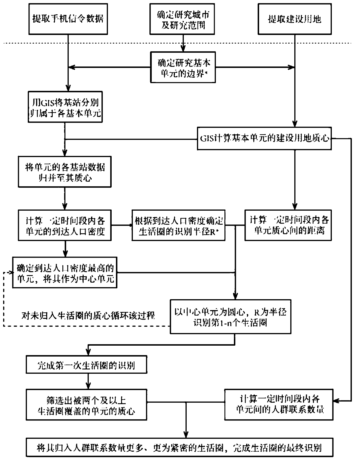
[0073] This embodiment provides a kind of community life circle spatial identification method, this method uses the administrative community boundary map and the construction map of the research area as the working base map, after calculating the distance between communities in the Arcgis software, using the China Mobile company's Cell phone signaling data is used as the main data source. Excel is used to clean up the data, and the spatial identification of the community life circle is completed through the double-overlay analysis of the community distance matrix and the non-commuting OD contact matrix in the Excel software. Such as figure 1 As shown, the method includes the following steps:

[0074] S1. Extracting mobile phone signaling data and construction land data.

[0075] In this embodiment, before extracting mobile phone signaling data and construction land data, the research city and research scope can be determined first, that is, limited to a certain urban area, to...

Embodiment 2

[0172] This embodiment is a specific application example, taking Guzhen Town, Zhongshan City, Guangdong Province as the research object, based on the realization of the space recognition method of the community life circle in the above-mentioned embodiment 1, and using the method of mobile phone signaling big data to propose from the perspective of crowd movement OD relationship The new identification method of living circle forms a complementary relationship with the traditional questionnaire and interview survey, and also improves the urban planning survey system.

[0173] 1) Organize the basic data of community life circle in Guzhen town

[0174] 1.1) Organize the construction land data of each community in Guzhen Town

[0175] Load the polyline in "Guzhen Town Construction Land CAD.dwg" into Arcgis, and save it as a shapefile "Guzhen Town Construction Land_Line.shp".

[0176] Use the line-to-surface tool on "Guzhen Town Construction Land_Line.shp" to generate "Guzhen Town...

Embodiment 3

[0226] Such as Figure 5 As shown, the present embodiment provides a community life circle space identification system, the system includes an extraction module 501, an arrangement module 502, a calculation module 503, an acquisition module 504, a search module 505, a first identification module 506 and a second identification module 507, the specific functions of each module are as follows:

[0227] The extracting module 501 is used for extracting mobile phone signaling data and construction land data.

[0228] The collation module 502 is used to collate the construction land data into the construction land data of each community.

[0229] The calculation module 503 is used to calculate the arrival population density of each community according to the mobile phone signaling data and the construction land data of each community.

[0230] The first generation module 504 is configured to obtain the construction land centroid of each community according to the construction land...


PUM


Abstract

The invention discloses a community life circle space identification method and system, computer equipment and a storage medium. The method comprises the following steps: extracting mobile phone signaling data and construction land data; organizing the construction land data into construction land data of each community; calculating the arrival population density of each community; obtaining a construction geologic center of each community, and generating an inter-centroid distance matrix as a community distance matrix; searching a community with the highest population density as a current central community; identifying a life circle of the current central community; and searching a new central community outside the service radius of the current central community, taking the new central community as the current central community, and returning to identify the life circle of the current central community until all communities are classified into the corresponding life circle. Accordingto the invention, the space division of the community life circle is realized according to the mobile phone signaling data and the construction land data of each community, the life circle is identified from the daily life travel of residents, and the concept of the life circle can be closer.

Description

technical field [0001] The invention relates to a space identification method, system, equipment and medium of a community life circle, and belongs to the field of quantitative measurement of a community life circle. Background technique [0002] The concept of "living circle" originated from the basic residential areas in Japan's land comprehensive development plan in the 1970s, which is the geographical distribution of daily production and living activities within a specific geographical and social village. More generally, the living circle is the spatial range or behavioral space formed by residents who take their homes as the center and carry out various trips such as shopping, leisure, commuting (study), social interaction, and medical treatment (Aitken, 1988; Algers, 2005; Tian , 2018). Compared with the economic connection of the general regional network, the living circle reflects the interactive relationship between the living space unit of the residents and the ac...

Claims


Application Information

Patent Timeline
IPC IPC(8): G06Q50/26
CPCG06Q50/26G06F16/29
Inventor 赵渺希陈佩谦陈奋填
Owner SOUTH CHINA UNIV OF TECH
Why Eureka
Try Eureka