Engineering investigation unmanned aerial vehicle system based on satellite positioning and navigation and surveying and mapping method

A technology of satellite positioning and engineering survey, which is applied to the automatic control system of drilling, motor vehicles, earthwork drilling and mining, etc., and can solve the problems of unmanned aerial vehicles staying, difficult to implement, and single

Pending Publication Date: 2020-06-16
南京智慧岩土工程技术研究院有限公司
View PDF0 Cites 6 Cited by
  • Summary
  • Abstract
  • Description
  • Claims
  • Application Information

AI Technical Summary

Problems solved by technology

[0005] Some patents on the use of UAVs for surveying, surveying, mapping, field management and sampling have appeared in my country, but most of the functions of these patents only stay in relatively simple aerial photography, sampling, etc.
They are still lacking in surveying an

Method used


Image

  • Engineering investigation unmanned aerial vehicle system based on satellite positioning and navigation and surveying and mapping method
  • Engineering investigation unmanned aerial vehicle system based on satellite positioning and navigation and surveying and mapping method
  • Engineering investigation unmanned aerial vehicle system based on satellite positioning and navigation and surveying and mapping method

Examples


Embodiment 1

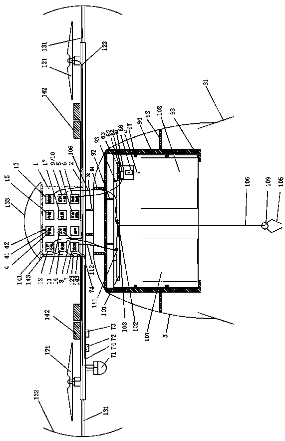
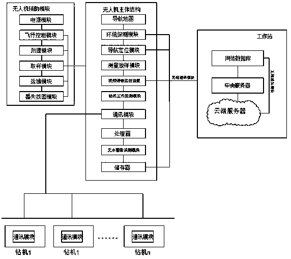
[0085] refer to Figure 1-9 , an engineering survey unmanned aerial vehicle system based on satellite positioning and navigation, comprising an unmanned aerial vehicle main body 1, a support arm 2, a propeller 121, a landing gear 3, a transport device 9, a sampling device 10, a power supply 14, a monitoring device 7, and a workstation 16 . The main body of the UAV 1 includes a navigation and positioning module 4, an environment detection module 5, a measurement and stakeout module 6, a survey work monitoring module 7, a wireless communication module 8, a transportation module 9, a sampling module 10, a text image recognition module 11, and a flight control module. 12. Anti-collision protection module 13, power supply module 14, memory 15, lost and retrieved module 17. A solar cell assembly 141 and a protective cover 133 are installed on the upper outside of the drone main body 1 . When the lithium battery 142 is exhausted, the solar cell assembly 141 can be used when the sun...

Embodiment 2

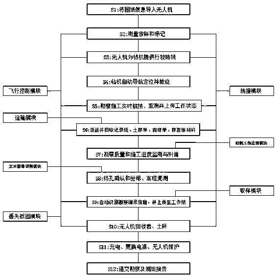
[0093] A surveying and mapping method of an engineering surveying drone based on navigation and positioning corresponding to this embodiment includes the following steps:

[0094] (1) Turn on the built-in RTK of the drone, bring the drone to the survey construction site, or fly the drone to the survey construction site by itself. Turn on the measurement and stakeout module, and use the drone to perform drilling measurement;

[0095] (2) The UAV flies to the actual position according to the preset drilling coordinates, turns on the built-in printer, automatically prints the drilling hole number as the hole number mark, and automatically pastes it on the stakeout flag, and then inserts it through the stakeout device the ground in which the borehole is located;

[0096] (3) In the later period, due to some reasons, the measurement mark was destroyed, and the UAV was used to measure and stake out again.

[0097] S3: Drones provide driving routes for drilling rigs. The specific ...


PUM

PropertyMeasurementUnit
Radiusaaaaaaaaaa

Abstract

The invention discloses an engineering investigation unmanned aerial vehicle system based on satellite positioning and navigation and an investigation surveying and mapping method. The engineering investigation unmanned aerial vehicle system comprises an unmanned aerial vehicle body, supporting arms, propellers, undercarriages, a transportation device, a sampling device, a power supply, a monitoring device and a workstation. The unmanned aerial vehicle body internally comprises a navigation positioning module, an environment detection module, a survey lofting module, a survey work monitoring module, a wireless communication module, a transportation module, a sampling module, a text image recognition module, a flight control module, an anti-collision protection module, a power supply module, a memory and a loss finding module. According to the invention, an advanced positioning navigation technology, a remote sensing image technology, a radar technology, a flight control technology, a real-time aerial image voice communication technology, an intelligent investigation technology, a text image recognition technology and a wireless transmission technology are adopted; geotechnical engineering investigation and high and new technologies are combined, and multiple important functions such as investigation automatic measurement and lofting, coordinate elevation remeasurement, drillingmachine navigation reminding, investigation work quality progress deviation rectification, automatic transportation and sampling, man-machine interaction, text image automation and unmanned aerial vehicle loss finding are achieved.

Description

technical field [0001] The invention relates to the technical field of geotechnical engineering survey, in particular to an engineering survey drone system based on satellite positioning and navigation and a survey and mapping method. Background technique [0002] In geotechnical engineering surveys, especially in industrial and civil construction surveys, drilling sampling and in-situ testing are still the most mainstream survey methods. At this stage, the working mode of geotechnical engineering survey field is still relatively primitive. In terms of measurement and setting out, drilling, sampling, in-situ testing, cataloging, sampling, etc., manual operation and handling are still the main methods. [0003] In terms of drilling survey and stakeout, technicians need to design the drilling plane position map in advance, and arrange surveyors to stake out and mark. During the construction process, the drilling rig personnel need to find the drilling marks by themselves, a...

Claims


Application Information

Patent Timeline
IPC IPC(8): B64C39/02B64D45/00B64D47/00E21B44/00
CPCB64C39/02B64D45/00B64D47/00E21B44/00Y02T50/50
Inventor 饶开永李俊才董平叶继权尚明林春明贺锦美张志铖刘松玉张鹏
Owner 南京智慧岩土工程技术研究院有限公司
Why Eureka
Try Eureka