Intelligent three-dimensional geological modeling method based on drilling data

A technology of 3D geology and drilling data, applied in 3D modeling, image data processing, instruments, etc., can solve the problems of inability to meet complex geological bodies and special engineering modeling requirements, low efficiency, low level of automation, etc., and achieve reliable Credible model foundation and support, expanding operable space, and improving the effect of automation level

Pending Publication Date: 2020-06-19
CCCC GUANGZHOU DREDGING
View PDF3 Cites 7 Cited by
  • Summary
  • Abstract
  • Description
  • Claims
  • Application Information

AI Technical Summary

Problems solved by technology

[0004] 1. It must be completed through a lot of manual intervention, the level of automation is low, the design modification is cumbersome, the production cycle is long, the efficiency is low, and it is easy to make mistakes;
[0005] 2. The two-dimensional interpolation method used to calculate the geological interface does not comprehensively consider the three-dimensional spatial information of the borehole group, and the three-dimensional spatial interpolation method is difficult to deal with common complex geological bodies such as stratum pinch-outs, intrusions, lenses, etc.;
[0006] 3. The functions provided by existing commercial software are quite basic...

Method used


Image

  • Intelligent three-dimensional geological modeling method based on drilling data
  • Intelligent three-dimensional geological modeling method based on drilling data
  • Intelligent three-dimensional geological modeling method based on drilling data

Examples


Embodiment Construction

[0029] The embodiments of the present invention are further described in detail below.

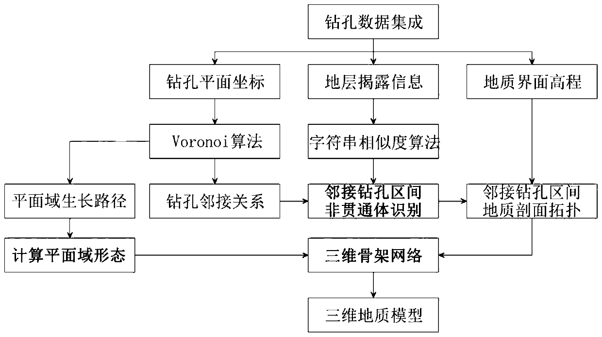
[0030] This embodiment provides an intelligent three-dimensional geological modeling method based on borehole data, such as figure 1 As shown, the method includes the following steps:

[0031] S1, identification of geological interlayers between adjacent boreholes:

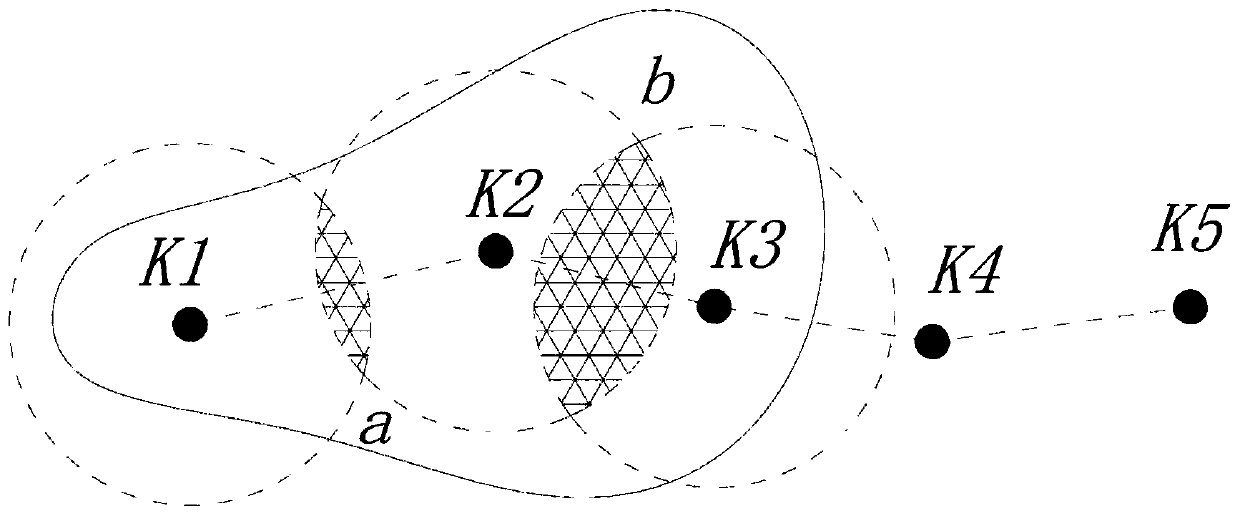
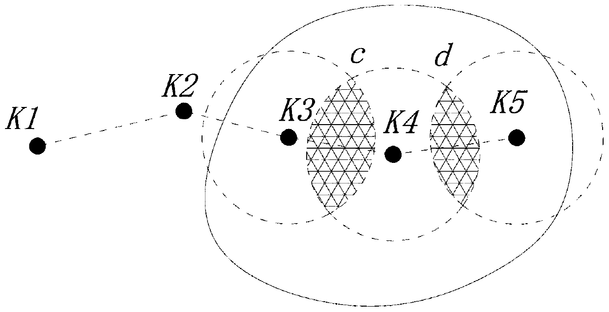
[0032]The total number of boreholes is n, and the borehole data is input, including latitude and longitude coordinates or xy plane coordinates, orifice elevation, the bottom elevation of each geological layer exposed by the borehole, and the inclination angle of the borehole. According to the coordinates, all the drilling points are projected on the xy two-dimensional plane, and the Voronoi algorithm is used to generate the Thiessen polygon distribution of the drilling group point cloud, that is, the Voronoi diagram. The adjacency relationship of the drilling points is determined by the common edge relationship of the Thiesse...


PUM


Abstract

The invention discloses an intelligent three-dimensional geological modeling method based on drilling data. Firstly, drilling group data are integrated, an adjacency relation matrix of a drilling group is determined according to a Voronoi algorithm, drilling geological disclosure information is converted into character string data, and a character string similarity algorithm is applied to identifya common subsequence of adjacent drilling character strings. And determining the growth path of the plane domain of the borehole group according to the Voronoi diagram, and solving the distribution form of each geosome in the projection area of the geodetic plane; introducing a new control point to the non-continuous through body in the adjacent drilling interval, connecting the continuous through geologic body and the control point, creating geological sections of the adjacent drilling interval, converting all the geological sections into a three-dimensional space to generate a three-dimensional geological skeleton network, and finally assembling to form a three-dimensional geological model. According to the method, automatic three-dimensional geological modeling can be directly carriedout on the complex geologic body based on the drilling data, the three-dimensional topological relation of the drilling group is comprehensively considered, the data utilization rate and the model precision are improved, and the method can be applied to BIM development and smart city construction.

Description

technical field [0001] The invention relates to a three-dimensional geological modeling technology, in particular to an intelligent three-dimensional geological modeling method based on drilling data. Background technique [0002] 3D geological modeling plays an important role in the BIM collaborative design of construction projects and the construction of smart cities. Due to the limitation of measurement methods, in surveying and surveying, it is often only possible to manually analyze the geological distribution based on a small amount of borehole data, and use various interpolation methods such as Kriging interpolation and inverse distance weighted interpolation to calculate the adjacent boreholes. Geological interface profiles within the interval. Then import a large number of geological horizontal and vertical sections into various foreign commercial software such as Civil 3D to generate a 3D geological model. [0003] This traditional 3D geological modeling method h...

Claims


Application Information

Patent Timeline
IPC IPC(8): G06T17/05G06T17/20
CPCG06T17/05G06T17/20
Inventor 殷达廖曾平张登泰黎忠豪喻明杰赵宁张日福
Owner CCCC GUANGZHOU DREDGING
Why Eureka
Try Eureka