Water area measurement method and system based on laser SLAM positioning

A measurement method and measurement system technology, applied in the field of surveying and mapping, can solve the problems of covering or weather factors, reducing measurement efficiency, lower than four, etc., to achieve the effect of rapid measurement methods

Active Publication Date: 2020-07-28
SOUTHEAST UNIV
View PDF9 Cites 16 Cited by
  • Summary
  • Abstract
  • Description
  • Claims
  • Application Information

AI Technical Summary

Problems solved by technology

These current methods have more or less corresponding shortcomings: ① When performing GPS measurement, each RTK needs at least 4 satellites to be visible to obtain a fixed solution. There may be less than four observation satellites. At this time, the GPS receiver cannot obtain a good fixed solution and cannot meet the requirements of real estate field measurement.
In the problem of boundary positioning of small waters, the total station can effectively measure specific points on the boundary, but if you want to accurately measure the boundary contour of small waters, it will lead to a large number of points to be measured, and the station setting process is cumbersome. Using a total station greatly reduces measurement efficiency
③Satellite remote sensing technology is a common technical solution for water boundary positioning. Many scholars have devoted themselves to the extraction of water body area from remote sensing images, but its spatial resolution is low, and it is more suitable for larger water areas
④ Aerial photography technology can install a special aerial camera on the aircraft to take pictures of ground or air targets from the air and draw maps. However, aerial photography is also similar to GPS-RTK technology, which is easily affected by tree cover or weather factors. Poor sex

Method used


Image

  • Water area measurement method and system based on laser SLAM positioning
  • Water area measurement method and system based on laser SLAM positioning
  • Water area measurement method and system based on laser SLAM positioning

Examples


Embodiment Construction

[0031] The technical solution of the present invention will be further described below in conjunction with the accompanying drawings.

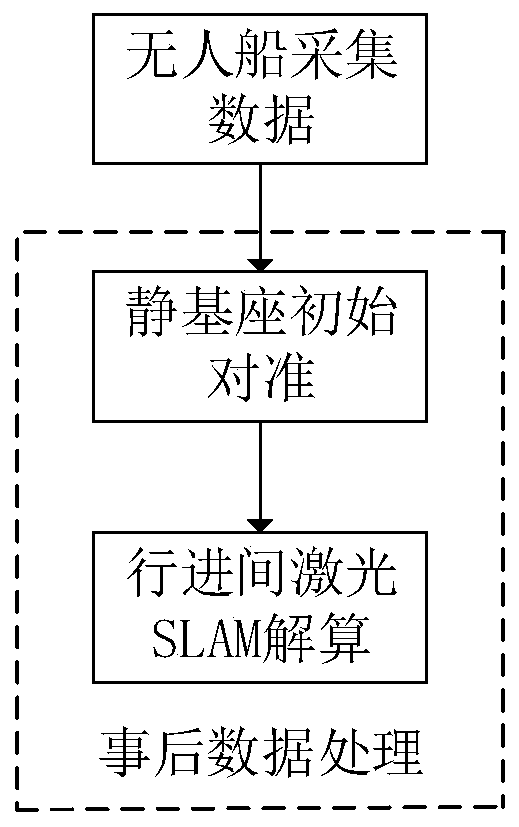
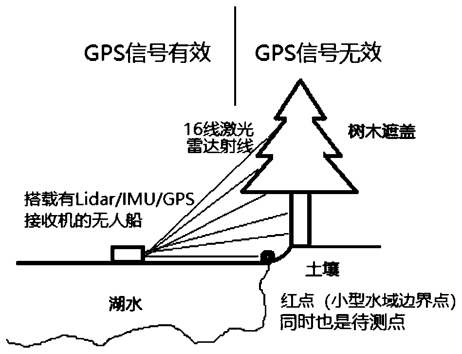
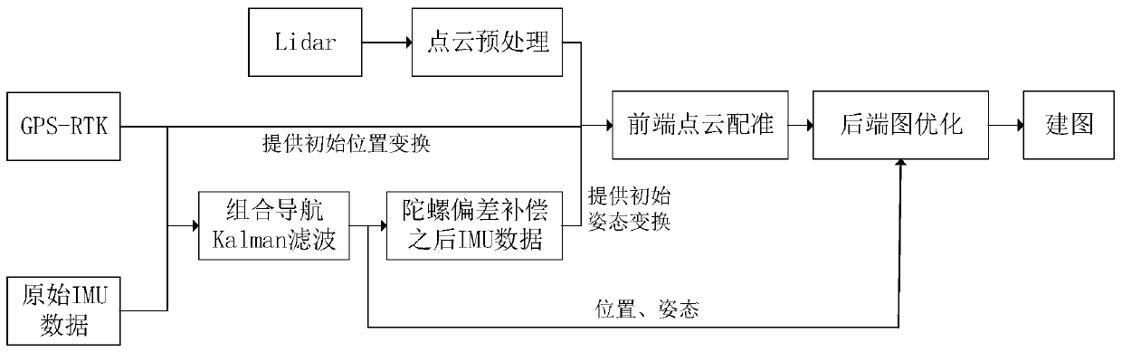
[0032] The laser SLAM scheme applied to the measurement of small water areas provided by the present invention can accurately measure the absolute geographical position of the water area boundary when the GPS signal of the small water area boundary fails, and the measurement efficiency is high. refer to figure 1 with image 3 , in one embodiment, the water area measurement method based on laser SLAM positioning comprises the following steps:

[0033] Step S1, using an unmanned ship equipped with a laser radar, an inertial measurement unit IMU, and a GPS receiver to measure the water area and collect data.

[0034] Stop the unmanned ship at the effective GPS point for 10 minutes, and then drive around the contour of the small water area. The specific driving trajectory needs to consider two factors: ① The distance from the boundary of the sma...


PUM


Abstract

The invention discloses a water area measurement method and system based on laser SLAM positioning, and belongs to the technical field of surveying and mapping. The method comprises the steps that: anunmanned ship carrying a laser radar, an inertial measurement unit IMU and a GPS receiver is used for measuring a water area and collecting data; stationary base initial alignment is carried out by utilizing acquired IMU and GPS data, and initial absolute position and attitude information is provided for subsequent laser SLAM calculation during advancing; point cloud preprocessing operation is carried out on data acquired by the laser radar according to a water area measurement environment; attitude transformation between two adjacent frames of point cloud is estimated by using the IMU, and an initial value is provide for point cloud registration; registration is performed on the point cloud by using a PPICP algorithm; integrated navigation pose information is added as an additional constraint to back-end graph optimization so as to improve solving precision; and according to the result of the back-end optimization, the three-dimensional coordinates of the point cloud are calculated,and a three-dimensional point cloud map is drawn, and the absolute position information of the boundary of the water area is marked. Accurate reference can be provided for overall protection and comprehensive treatment of the water area.

Description

technical field [0001] The invention belongs to the technical field of surveying and mapping, and in particular relates to a method and system for measuring water areas. Background technique [0002] Small waters such as rural fish ponds and small lakes have irregular shapes and complex surrounding environments. The positioning, surveying and mapping of the boundaries of small waters has always been a research hotspot for scholars in the industry. The commonly used surveying and mapping methods for real estate units such as small waters currently include GPS surveying, total station surveying, satellite remote sensing and aerial photography. These current methods have more or less corresponding shortcomings: ① When performing GPS measurement, each RTK needs at least 4 satellites to be visible to obtain a fixed solution. The number of observation satellites may be less than four. At this time, the GPS receiver cannot obtain a good fixed solution and cannot meet the requireme...

Claims


Application Information

Patent Timeline
Patent Type & Authority Applications(China)
IPC IPC(8): G01C13/00G01S19/53G01S19/48G01S19/49G01C21/16
CPCG01C13/00G01C21/165G01S19/48G01S19/49G01S19/53Y02A90/30
Inventor 吴峻刘凯郭晓艺
Owner SOUTHEAST UNIV
Why Eureka
Try Eureka