Airborne laser radar data-based oblique photography modeling method for complex mountainous area

An airborne laser radar and modeling method technology, applied in the field of aerial photogrammetry, can solve the problems of poor image resolution consistency and difficult measurement of field image control points, so as to ensure consistency, improve accuracy, and improve overall accuracy Effect

Active Publication Date: 2020-07-28
CHINA RAILWAY FIRST SURVEY & DESIGN INST GRP
View PDF6 Cites 17 Cited by
  • Summary
  • Abstract
  • Description
  • Claims
  • Application Information

AI Technical Summary

Problems solved by technology

[0006] The purpose of the present invention is to provide an oblique photographic modeling method based on airborne lidar data in complex mountainous areas to solve the problems of poor consistency of image resolution and difficult measurement of field image control points in three-dimensional oblique modeling of complex mountainous areas

Method used


Image

  • Airborne laser radar data-based oblique photography modeling method for complex mountainous area
  • Airborne laser radar data-based oblique photography modeling method for complex mountainous area
  • Airborne laser radar data-based oblique photography modeling method for complex mountainous area

Examples


Embodiment

[0074] In a railway survey and design project in a complex mountainous area in the west, according to the terrain characteristics of different work areas, the 3D oblique real scene modeling technology based on the helicopter and UAV platform was adopted, and the AMC5100 digital oblique aerial photography was carried on the helicopter platform at the same time instrument and Riegl VUX-1LR long-range airborne lidar (see Figure 6 ), equipped with RiY-DG4 small digital tilting aerial camera and Riegl VUX-1LR long-range airborne lidar on the UAV platform, and completed the project of about 700 square kilometers of important work points along the line in a short period of time. The 3D tilt data acquisition and modeling production work provide an intuitive, real and high-precision 3D real scene model for railway survey, which has been applied in the fields of geological survey, line selection, bridge and tunnel design, surveying and mapping, and railway BIM design. It enriches the r...


PUM


Abstract

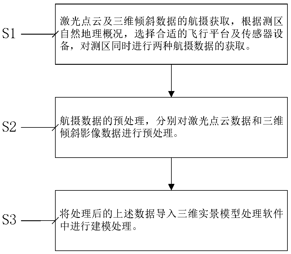
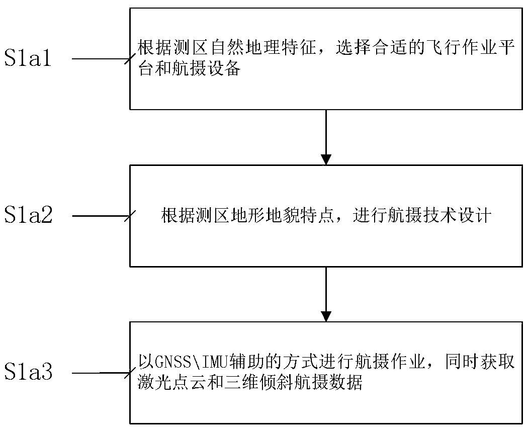
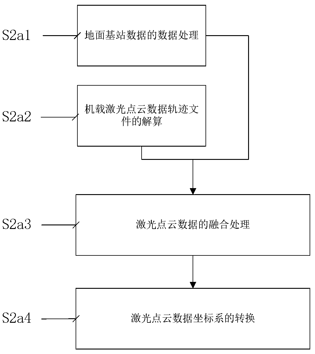
The invention relates to an airborne laser radar data-based oblique photography modeling method for complex mountainous area. The method comprises the following steps of: selecting a proper flight platform and an aerial photography sensor, performing aerial photography design according to the requirements of a three-dimensional real scene modeling scale, and simultaneously acquiring two kinds of data of the same measurement area; preprocessing laser point cloud data and three-dimensional oblique image data; and importing the processed point cloud data and the three-dimensional oblique image data into three-dimensional real scene modeling software for processing, and constructing a three-dimensional real scene model. According to the method of the invention, an aerial photography scheme forself-adaptive variable-height flight of an airline is provided for the first time; a digital oblique aerial camera and an airborne laser radar are carried through a proper flight platform to obtain data at the same time; the advantages of high-precision geographic coordinates of the laser point cloud data and the high resolution of the three-dimensional oblique real scene model are fused, the problems of poor resolution consistency of the three-dimensional oblique modeling images of the complex mountainous area and difficulty in the measurement of image control points are solved, and the precision of three-dimensional oblique real scene modeling of the complex mountainous area is effectively improved.

Description

technical field [0001] The invention belongs to the technical field of aerial photogrammetry, and in particular relates to an oblique photography modeling method based on airborne laser radar data in complex mountainous areas. Background technique [0002] There are currently the following problems in the real scene modeling of 3D oblique photography in complex mountainous areas: [0003] 1. Mountainous areas have large undulations. In the case of the same absolute flight height in the survey area, the acquired images have different ground resolutions. The ground resolutions of the same feature on adjacent images are inconsistent, which is not conducive to image matching and affects 3D construction. Mode precision effect. [0004] 2. In complex mountainous areas, the mountains are high and the slopes are steep, and it is difficult for personnel to reach them. It is impossible to arrange image control points according to conventional aerial photography field work, which dire...

Claims


Application Information

Patent Timeline
Patent Type & Authority Applications(China)
IPC IPC(8): G01S17/89G01S17/86G01C11/08G01C11/34G06T17/10
CPCG01S17/89G01C11/08G01C11/34G06T17/10Y02A90/10
Inventor 刘亚林袁永信肖永飞张占忠李丹武瑞宏何金学张齐勇
Owner CHINA RAILWAY FIRST SURVEY & DESIGN INST GRP
Why Eureka
Try Eureka