Three-dimensional laser scanning and GPS-PPK combined measurement method

A three-dimensional laser, measurement method technology, applied in measurement devices, height/level measurement, mapping and navigation, etc., can solve the problems of high intensity of field work, difficult to monitor large-scale deformation, and the influence of weather conditions, and achieve improved coordinates. The effect of absolute position accuracy, increasing measurement cost burden, and improving detection accuracy

Active Publication Date: 2020-08-21
CHINA UNIV OF MINING & TECH
View PDF4 Cites 5 Cited by
  • Summary
  • Abstract
  • Description
  • Claims
  • Application Information

AI Technical Summary

Problems solved by technology

However, this method has disadvantages such as difficulty in saving measurement points, high field work intensity, and less effective data acquisition.
In 2011, C.Liu et al. applied GPS-RTK (carrier phase difference technology) to mining subsidence monitoring. Although the working time was shortened, it still faced problems similar to traditional measurement methods, and GPS-RTK (carrier phase difference technology) Differential technology) has a horizontal position accuracy of only 1-4cm and a vertical accuracy of 2-8cm; the measurement quality is also easily affected by multipath effects, satellite signal blocking and weather conditions
However, the deformation amount monitored by In SAR technology in a unit pixel is limited, and the accurate ground surface deformation cannot be obtained beyond the critical gradient. Chen et al pointed out that the phase change between a unit pixel and adjacent pixels does not exceed 1 / 4 wavelength Phase unwrapping can be avoided when the D-InSAR technology is improved to monitor the maximum subsidence, but the maximum subsidence value that can be monitored by each satellite system is still only a few centimeters to tens of centimeters (when the mining depth is 100 meters), so it is difficult to monitor a large amount of subsidence. Grade deformation

Method used


Image

  • Three-dimensional laser scanning and GPS-PPK combined measurement method
  • Three-dimensional laser scanning and GPS-PPK combined measurement method
  • Three-dimensional laser scanning and GPS-PPK combined measurement method

Examples


specific Embodiment

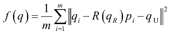
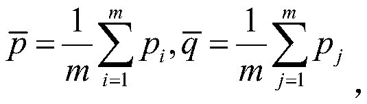
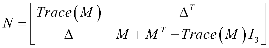
[0053] When GPS-PPK and 3D laser scanning are simultaneously measured, radiation targets and GPS receivers are placed on 6 measuring points, and GPS-PPK measurement and 3D laser scanning measurement are performed simultaneously.

[0054] Using Huatest X91 dual-frequency GPS receiver combined with Rigel VZ1000 3D laser scanner, the data of 5 time periods were acquired with a single-station acquisition time of 30 minutes.

[0055] Among the 5 sets of data, the GPS measurement data is WGS84 coordinate data, and the TLS data is scanner coordinate system data. In order to realize the unification of the coordinate system, the coordinate conversion is carried out based on the reference data of the experimental field obtained in the previous section. After the conversion, subtract The five sets of data of instrument constants are shown in Table 1-Table 5.

[0056] Table 1 Measurement results of the first period

[0057]

[0058] Table 2 Measurement results of the second period

...


PUM


Abstract

The invention discloses a three-dimensional laser scanning and GPS-PPK combined measurement method which is suitable for the field of surveying and mapping. An observation station is arranged at the central position of a to-be-tested area, and GPS targets are averagely arranged in the to-be-tested area to ensure that the included angle of connecting lines between the targets is 30-60 degrees; GPSdata of a plurality of time periods are acquired according to the single-station acquisition time of unit time; three-dimensional laser scanning point cloud data of the to-be-tested area and GPS dataof the GPS target are obtained; high-precision target control point coordinates are provided by GPS-PPK measurement, three-dimensional laser scanning is carried out to obtain high-precision point cloud relative coordinate data, and the GPS coordinate data as a standard is substituted into the three-dimensional laser point cloud data coordinates of the GPS target points, so that the point cloud data of the observation station and the GPS data of the GPS targets are fused, and finally the high-precision absolute coordinate information of the point cloud data of the to-be-tested area is obtained.Three-dimensional laser scanning and GPS-PPK measurement can be effectively fused, and an effective, high-precision and reliable data basis can be provided for mining subsidence large-range deformation monitoring work.

Description

technical field [0001] The invention relates to a combined measurement method, and is especially suitable for a combined measurement method of three-dimensional laser scanning and GPS-PPK used in environmental surveying and mapping engineering. Background technique [0002] China is the world's largest coal producer, accounting for 42% of global output, 96% of which comes from underground coal mining. Underground coal mining will inevitably cause land subsidence, which will seriously affect the surface conditions (1). The exploitation of underground mineral resources has brought huge material wealth but at the same time destroyed the natural environment. [0003] The data used in the study of displacement caused by coal mining can be obtained directly from the field today, and the traditional measurement methods include leveling and total station surveying. However, this method has disadvantages such as difficulty in saving measurement points, high field work intensity, an...

Claims


Application Information

Patent Timeline
Patent Type & Authority Applications(China)
IPC IPC(8): G01C5/00
CPCG01C5/00
Inventor 李亮吴侃白志辉曹兴砚贾秉松董祥吴志聪
Owner CHINA UNIV OF MINING & TECH
Why Eureka
Try Eureka