
Remote sensing imaging principle-based earth surface vegetation distribution recognition method

A technology of surface vegetation and remote sensing imaging, applied in the field of surface vegetation identification, can solve problems such as large errors and large picture quality, and achieve the effects of suppressing noise problems, improving efficiency, and improving accuracy

Inactive Publication Date: 2020-08-28
FOSHAN GAOMING XILUO TECH CO LTD
View PDF0 Cites 7 Cited by
  • Summary
  • Abstract
  • Description
  • Claims
  • Application Information

AI Technical Summary

Problems solved by technology

[0003] Blockchain (Blockchain) is an important concept of Bitcoin. It is essentially a decentralized database. At the same time, as the underlying technology of Bitcoin, it is a series of data blocks associated with cryptographic methods. Each The data block contains a batch of bitcoin network transaction information, which is used to verify the validity of the information (anti-counterfeiting) and generate the next block, combining blockchain technology with remote sensing imaging for regional surface vegetation identification and monitoring, It can realize the efficiency of detection and the security of monitoring data. During the monitoring process, the data transmission is automatically identified and transmitted through the Internet of Things to ensure the rapidity of data transmission. Most of the distribution of solar panels in the existing detection area is through unmanned monitoring. In the process of aerial photography, due to the influence of factors such as pixels or weather, the quality of the shooting picture is relatively high, and the error is relatively large. In order to be able to accurately analyze the distribution area and distribution characteristics of the surface vegetation, we carried out For regional detection, in order to better carry out regional planning, and analysis of vegetation distribution or vegetation growth characteristics, it is necessary to develop a matching system for detection and accurately obtain the distribution of solar panels, but in the detection process, how to Realizing accurate detection and how to process the detection results during the detection process are urgent problems to be solved

Method used


Image

  • Remote sensing imaging principle-based earth surface vegetation distribution recognition method
  • Remote sensing imaging principle-based earth surface vegetation distribution recognition method
  • Remote sensing imaging principle-based earth surface vegetation distribution recognition method

Examples


Embodiment Construction

[0054] In order to understand the above objects, features and advantages of the present invention more clearly, the present invention will be further described in detail below with reference to the accompanying drawings and specific embodiments. It should be noted that the embodiments of the present application and the features in the embodiments may be combined with each other in the case of no conflict.

[0055] Many specific details are set forth in the following description to facilitate a full understanding of the present invention. However, the present invention can also be implemented in other ways different from those described herein. Therefore, the protection scope of the present invention is not limited by the specific details disclosed below. Example limitations.

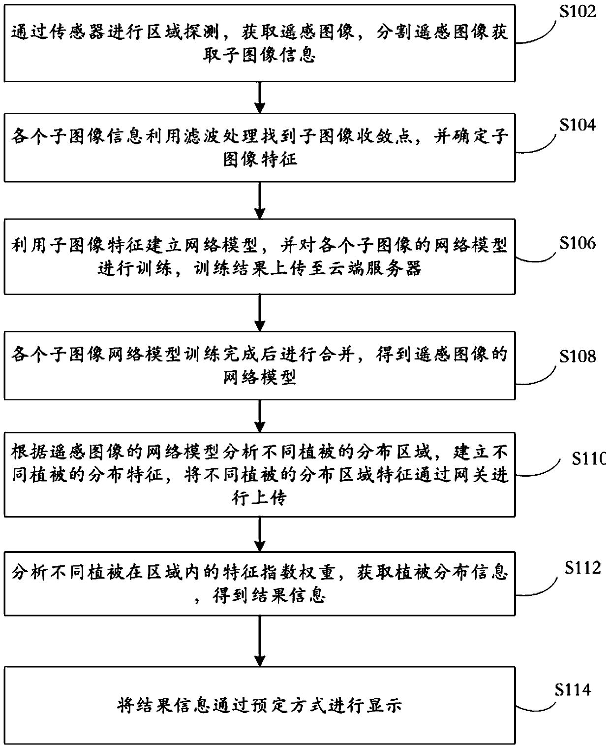
[0056] figure 1 A flow chart of a method of the present invention for identifying the distribution of surface vegetation based on the principle of remote sensing imaging is shown.

[0057]A first aspec...


PUM


Abstract

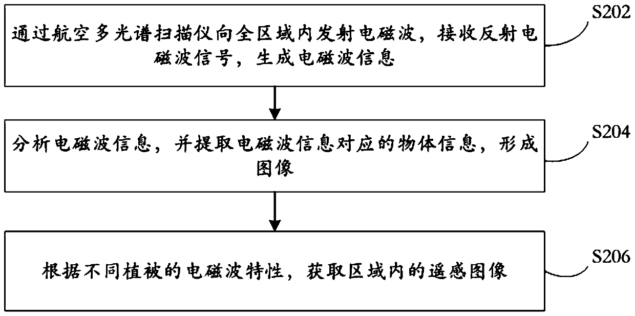
The invention relates to a remote sensing imaging principle-based earth surface vegetation distribution recognition method, which comprises the steps of performing region detection through a sensor, obtaining a remote sensing image, and segmenting the remote sensing image to obtain sub-image information; finding a sub-image convergence point of each piece of sub-image information by utilizing filtering processing, and determining sub-image features; utilizing the sub-image features to establish a network model, training the network model of each sub-image, and uploading a training result to acloud server; after the sub-image network models are trained, combining the sub-image network models to obtain a network model of the remote sensing image; analyzing the distribution areas of different vegetations according to the network model of the remote sensing image, establishing the distribution characteristics of different vegetations, and uploading the distribution area characteristics ofdifferent vegetations through a gateway; analyzing the characteristic index weights of different vegetations in the region, obtaining vegetation distribution information, and obtaining result information; and displaying the result information in a predetermined manner.

Description

technical field [0001] The invention relates to the field of surface vegetation identification or big data processing, in particular to a method for identifying the distribution of surface vegetation based on the principle of remote sensing imaging. Background technique [0002] At present, remote sensing technology has been widely used in agriculture, forestry, surveying and mapping, meteorology, transportation, land and resources exploration and other fields. A technology that detects and receives information from a target object from a distance through instruments or sensors, and identifies the attributes and distribution of objects through information transmission and analysis. [0003] Blockchain (Blockchain) is an important concept of Bitcoin. It is essentially a decentralized database. At the same time, as the underlying technology of Bitcoin, it is a series of data blocks generated using cryptographic methods. The data block contains a batch of Bitcoin network trans...

Claims


Application Information

Patent Timeline
Patent Type & Authority Applications(China)
IPC IPC(8): G06K9/00G06K9/34G06K9/40G06N3/04G06N3/08G06F16/27G06F21/60G06F21/64
CPCG06N3/08G06F16/27G06F21/602G06F21/64G06V20/188G06V10/267G06V10/30G06N3/045
Inventor 蒋晓玲许加明
Owner FOSHAN GAOMING XILUO TECH CO LTD
Learn More