Method for predicting ocean fishery resource abundance by integrating multi-source satellite remote sensing and application thereof

A technology for satellite remote sensing and fishery resources, applied in forecasting, data processing applications, neural learning methods, etc., can solve problems such as poor forecasting accuracy, and achieve the effects of improving accuracy, good convenience, and reducing difficulty

Pending Publication Date: 2020-09-11
SHANGHAI OCEAN UNIV
View PDF2 Cites 5 Cited by
  • Summary
  • Abstract
  • Description
  • Claims
  • Application Information

AI Technical Summary

Problems solved by technology

[0005] The purpose of the present invention is to overcome the defects of poor prediction accuracy in the prior art, and provide a method for predicting the resource abundance of pelagic fishery (suitable for squid) with high prediction accuracy

Method used


Image

  • Method for predicting ocean fishery resource abundance by integrating multi-source satellite remote sensing and application thereof
  • Method for predicting ocean fishery resource abundance by integrating multi-source satellite remote sensing and application thereof
  • Method for predicting ocean fishery resource abundance by integrating multi-source satellite remote sensing and application thereof

Examples


Embodiment 1

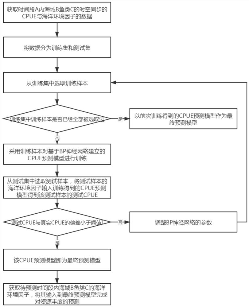
[0049] A method of comprehensive multi-source satellite remote sensing to predict the abundance of pelagic fishery resources, such as figure 1 As shown, the steps are as follows:

[0050] (1) From May to December of 2004 to 2017, the coordinate range is 35° to 50°N, 150° to 175°E, and the production statistics data of soft fish in May to December of 2004 to 2017, and the coordinate range is 35° °~50°N, 150°~175°E The data of marine environmental factors obtained by multi-source satellite remote sensing are processed (in the time domain, the average processing is performed according to the specified time resolution (month), and in the space domain, according to 1 °×1° spatial resolution for resampling), to obtain the time-space synchronized CPUE and marine environment of softfish in the coordinate range of 35°-50°N and 150°-175°E from May to December 2004 to 2017 The marine environmental factors include seawater mass change, geostrophic current, sea surface temperature (SST), ...

Embodiment 2

[0091] an electronic device such as Figure 18 As shown, including one or more processors, one or more memories, one or more programs and data collection devices;

[0092] The data collection device is used to obtain the production statistics of fish C in sea area B in time period A, the data of marine environmental factors obtained by multi-source satellite remote sensing in sea area B in time period A, and the production statistics of fish C in sea area B in time period to be predicted. For the data of marine environmental factors, one or more programs are stored in the memory, and when one or more programs are executed by the processor, the electronic device executes the comprehensive multi-source satellite remote sensing prediction of the abundance of pelagic fishery resources as described in Embodiment 1. degree method.


PUM


Abstract

The invention discloses a method for predicting ocean fishery resource abundance by integrating multi-source satellite remote sensing and application thereof. The method for predicting comprises the steps of processing the production statistical data of the fishes C in the sea area B in the time period A and the data of the marine environment factors including the seawater quality change and the earth transfer flow acquired by the multi-source satellite remote sensing of the sea area B in the time period A to obtain the data of the CPUE and the marine environment factors of the fishes C in thesea area B in the time period A in time-space synchronization; training and testing a CPUE prediction model established based on a BP neural network by using the obtained data to obtain a final prediction model; and inputting the marine environmental factors of the sea area B fish C in the to-be-predicted time period into the final prediction model to complete the prediction of the CPUE of the sea area B fish C in the to-be-predicted time period. According to the prediction method, the seawater quality change and the ground diversion flow are taken as marine environment factors for the firsttime, so that the prediction precision is improved, the prediction stability is improved, and the prediction method has a great application prospect.

Description

technical field [0001] The invention belongs to the technical field of pelagic fishery flood forecasting, and relates to a method for predicting the abundance of pelagic fishery resources through comprehensive multi-source satellite remote sensing and its application. Background technique [0002] Squid is an economically important cephalopod species with great development potential, widely distributed in the Pacific Ocean. Squid is divided into two breeding groups: winter and spring populations and autumn populations, of which the western populations of winter and spring populations are the main fishing targets of squid fishing boats in my country, with an annual output of up to more than 100,000 tons. Squid is a species with a short life cycle, and its life history process is closely related to the marine environmental conditions of its habitat. The temporal and spatial distribution and changes of marine environmental factors significantly affect the distribution range and...

Claims


Application Information

Patent Timeline
Patent Type & Authority Applications(China)
IPC IPC(8): G06Q10/04G06Q50/02G06N3/08
CPCG06N3/084G06Q10/04G06Q50/02
Inventor 常亮陈新军冯贵平余为李阳东温世强
Owner SHANGHAI OCEAN UNIV
Why Eureka
Try Eureka