Three-dimensional GIS real-time cloud rendering display method, terminal, cloud server and storage medium

A cloud server and real-time rendering technology, applied in structured data retrieval, transmission systems, electrical components, etc., can solve the problems of low JavaScript operation efficiency, hidden dangers of data security, and low performance, so as to improve experience, ensure security, and reduce required effect

Inactive Publication Date: 2020-10-13
武汉大势智慧科技有限公司
View PDF5 Cites 9 Cited by
  • Summary
  • Abstract
  • Description
  • Claims
  • Application Information

AI Technical Summary

Problems solved by technology

The difference between the BS architecture and the CS architecture is that JavaScript has low operating efficiency and does not allow the establishment of physical caches. The performance is usually much lower than that of the CS architecture. However, the advantage of BS is that it does not need to install any plug-ins or local applications. Can operate the 3D GIS system to complete the application function
In order to improve the efficiency of 3D GIS data visualization, various research algorithms have been optimized in terms of LOD construction, cache construction technology, data simplification, and geometric compression. show problem
[0006] Regardless of the PC architecture, CS

Method used


Image

  • Three-dimensional GIS real-time cloud rendering display method, terminal, cloud server and storage medium
  • Three-dimensional GIS real-time cloud rendering display method, terminal, cloud server and storage medium
  • Three-dimensional GIS real-time cloud rendering display method, terminal, cloud server and storage medium

Examples


Embodiment Construction

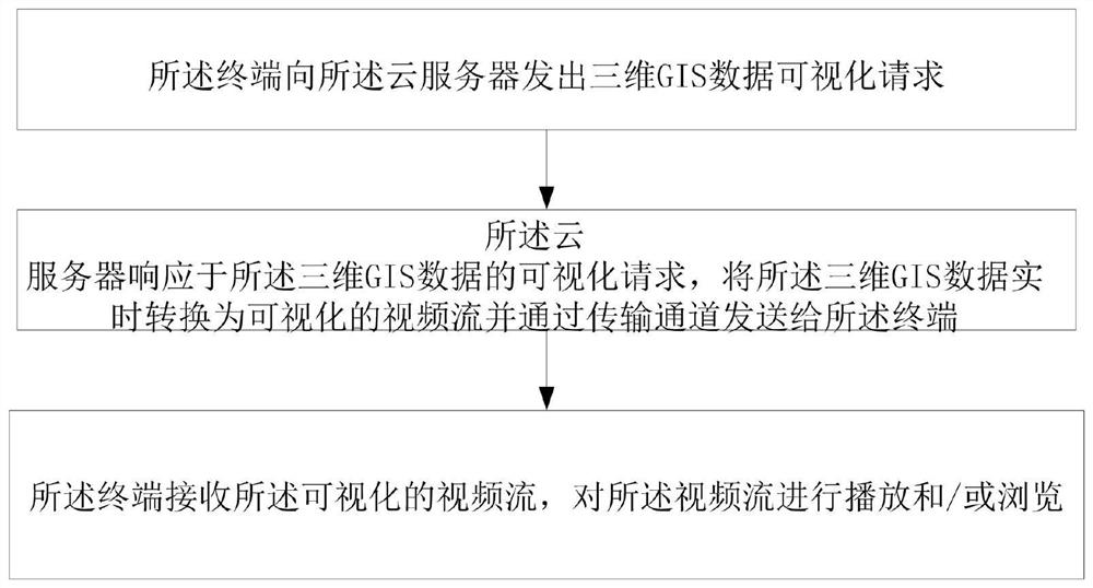
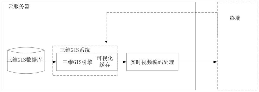
[0025] A three-dimensional GIS real-time cloud rendering display method, comprising a terminal and a cloud server, the terminal sends a three-dimensional GIS data visualization request to the cloud server; the cloud server responds to the visualization request of the three-dimensional GIS data, converts the three-dimensional GIS data into a visualized video stream and Send to the terminal through the transmission channel; the terminal receives the visualized video stream, and plays and / or browses the video stream in real time.

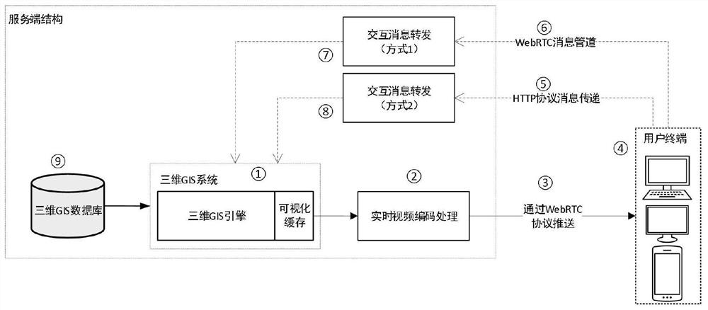
[0026] In some embodiments of the present invention, the terminal sends a three-dimensional GIS data visualization request to the cloud server. Specifically, the user uses the mouse, keyboard, touch, or a function call to generate a message according to the interaction mode suitable for each terminal. The interactive message between the user terminal and the cloud server may be transmitted through the network through at least one of two protocols, WebRT...


PUM


Abstract

The invention provides a three-dimensional GIS real-time cloud rendering display method, which comprises a terminal and a cloud server, and is characterized in that the terminal sends a three-dimensional GIS data visualization request to the cloud server; the cloud server responds to the visualization request of the three-dimensional GIS data, converts the three-dimensional GIS data into a visualized video stream in real time and sends the visualized video stream to the terminal through a transmission channel; and the terminal receives the visual video stream, and plays and/or browses the video stream. A rendering video compression and transmission service is added between a three-dimensional GIS platform and a user interaction terminal, the original rendering drawing of the three-dimensional GIS is directly drawn at the client, drawing is changed into drawing at the server side and a drawing result is transmitted to the client side in a real-time video streaming mode instead of an original mode that drawing of the three-dimensional GIS data is completed at the client side, so that the requirement of the system for the hardware capability of the client side is reduced, and the experience of a user in three-dimensional GIS application is improved.

Description

technical field [0001] The present invention relates to visualization technology of 3D geographic information system, technology related to video stream transmission and network rendering, in particular to a method for visual display and interaction of 3D geographic information system (3D GIS) through real-time cloud rendering technology. Background technique [0002] Geographic Information System (Geographic Information System or Geo-Information system, referred to as: GIS) is a system platform for geographic-related information management. It usually needs to process and display massive location-related data. It is widely used in national production and life and military applications. It has important application value. In the 3D geographic information system (referred to as: 3D GIS) and related applications, the main management is based on 3D data. 3D GIS is not only used in the field of smart cities, but also in the application of BIM (Build Information Model) in the fie...

Claims


Application Information

Patent Timeline
IPC IPC(8): H04N13/194H04N13/161H04N13/106H04N21/643H04N21/6437H04L29/08G06F16/29G06F16/28
CPCG06F16/287G06F16/29H04L67/02H04N21/643H04N21/6437H04N13/106H04N13/161H04N13/194
Inventor 刘湘泉徐亮
Owner 武汉大势智慧科技有限公司
Why Eureka
Try Eureka