
Radar altimeter waveform re-tracking method based on multi-scale peak monitoring

A technology of radar altimeter and peak monitoring, which is applied in measuring devices, radio wave measurement systems, radio wave reflection/re-radiation, etc. It can solve the problems of accuracy impact, algorithm inability to take into account both mountain lakes and plain lakes, system deviation, etc.

Active Publication Date: 2020-10-23
AEROSPACE INFORMATION RES INST CAS
View PDF7 Cites 3 Cited by
  • Summary
  • Abstract
  • Description
  • Claims
  • Application Information

AI Technical Summary

Problems solved by technology

[0003]There are some limitations in existing waveform re-tracking methods, mainly in the following aspects: 1) The complex terrain and non-sub-satellite point observations cannot be fully considered The impact on the altimeter waveform, the processing ability of some complex multi-peak waveforms is weak; 2) When performing multi-source altimeter water level inversion, there is a problem of re-tracking algorithm selection for different altimeter data, and there are differences between different re-tracking algorithms. The corresponding system deviation will affect the accuracy of the water level data fusion to a certain extent; 3) Due to the influence of the terrain in the surrounding area, the existing algorithm cannot take into account both mountain lakes and plain lakes

Method used


Image

  • Radar altimeter waveform re-tracking method based on multi-scale peak monitoring
  • Radar altimeter waveform re-tracking method based on multi-scale peak monitoring
  • Radar altimeter waveform re-tracking method based on multi-scale peak monitoring

Examples


Embodiment approach

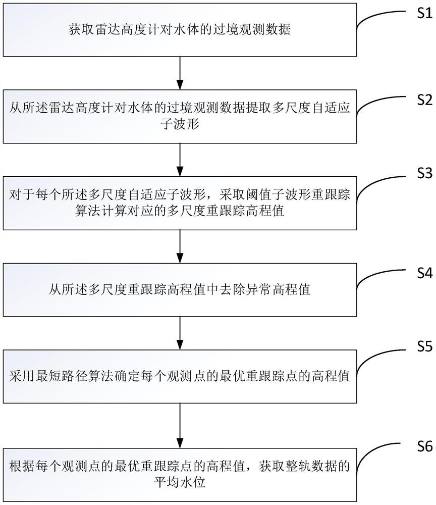
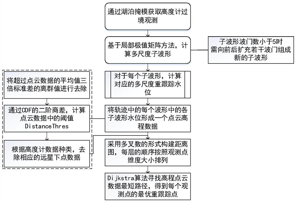
[0048] see figure 2 , according to an embodiment of the radar altimeter waveform re-tracking method based on multi-scale peak monitoring of the present invention, comprising the following steps:

[0049] A. Obtain the transit observation data of the water body from the radar altimeter of the Cryosat-2 or Sentinel-3 satellite through the lake mask.

[0050] B. Extraction of multi-scale adaptive sub-waveforms from radar altimeter observation data of water body transit based on local extrema matrix method

[0051] For the observation data of radar altimeter passing through water bodies, the method based on local extremum matrix is ​​used to detect waveform peaks to extract multi-scale adaptive sub-waveforms, which can detect as many waveform peaks as possible without occupying too much memory . Such as image 3 Two special waveforms in the image 3 The water surface signal reflection point in (a) exists in the third small wave peak; image 3 The waveform in (b) is multi-pea...


PUM


Abstract

The invention discloses a radar altimeter waveform re-tracking method based on multi-scale peak monitoring. The radar altimeter waveform re-tracking method comprises the following steps: acquiring transit observation data of a radar altimeter for a water body; extracting multi-scale adaptive sub-waveforms from the transit observation data of the radar altimeter to the water body; for each multi-scale adaptive sub-waveform, calculating a corresponding multi-scale re-tracking elevation value by adopting a threshold sub-waveform re-tracking algorithm; removing an abnormal elevation value from themulti-scale re-tracking elevation value; and determining the elevation value of the optimal re-tracking point of each observation point by adopting a shortest path algorithm. According to the method,the processing capacity of the multi-wave crest waveform is improved through a universal statistical method and the method can be applied to various altimeter data, meanwhile, the problem that an existing waveform re-tracking method is limited by surrounding area terrain influences is solved, the waveform re-tracking method can be used for mountainous lakes and plain lakes, and the waveform re-tracking method has important significance in lake water level change monitoring on a large space scale.

Description

technical field [0001] The invention relates to the field of remote sensing water level inversion, in particular to a radar altimeter waveform re-tracking method based on multi-scale peak monitoring. Background technique [0002] Satellite radar altimetry is an important tool for monitoring the level of oceans and inland water bodies, especially in areas where there is no or little measured data. The altimeter measurement of the water level of inland water bodies is often affected by land echo signals. This situation can usually be improved by waveform retracking, that is, the initial distance calculated from the two-way time of the pulse echo is corrected. The waveform retracking of inland water bodies has achieved many research results. The following are some classic methods: NPPR (The Narrow Primary Peak Retracker) retracking algorithm based on the maximum reflected energy of the water surface to monitor the main peak of the echo (Jain M, Andersen O B ,Dall J, et al.Sea ...

Claims


Application Information

Patent Timeline
IPC IPC(8): G01S13/88G01S7/292G01S7/35
CPCG01S13/882G01S7/2927G01S7/354Y02A90/30
Inventor 廖静娟陈嘉明
Owner AEROSPACE INFORMATION RES INST CAS
Learn More