Satellite interference measurement method for frozen soil seasonal deformation

A technology of interferometric measurement and deformation, applied in the direction of measuring device, radio wave measurement system, radio wave reflection/re-radiation, etc., can solve the problem of phase time imbalance and achieve the effect of improving reliability and accuracy

Pending Publication Date: 2020-10-23
SOUTHWEST JIAOTONG UNIV
View PDF6 Cites 6 Cited by
  • Summary
  • Abstract
  • Description
  • Claims
  • Application Information

AI Technical Summary

Problems solved by technology

[0007] In view of the above-mentioned deficiencies in the prior art, the satellite interferometry method of seasonal deformation of frozen soil provided by the present invention solves the problem that the monitoring of surface deformation in frozen soil area is affected by phase time loss correlation

Method used


Image

  • Satellite interference measurement method for frozen soil seasonal deformation
  • Satellite interference measurement method for frozen soil seasonal deformation
  • Satellite interference measurement method for frozen soil seasonal deformation

Examples


Embodiment Construction

[0018] The specific embodiments of the present invention are described below so that those skilled in the art can understand the present invention, but it should be clear that the present invention is not limited to the scope of the specific embodiments. For those of ordinary skill in the art, as long as various changes Within the spirit and scope of the present invention defined and determined by the appended claims, these changes are obvious, and all inventions and creations using the concept of the present invention are included in the protection list.

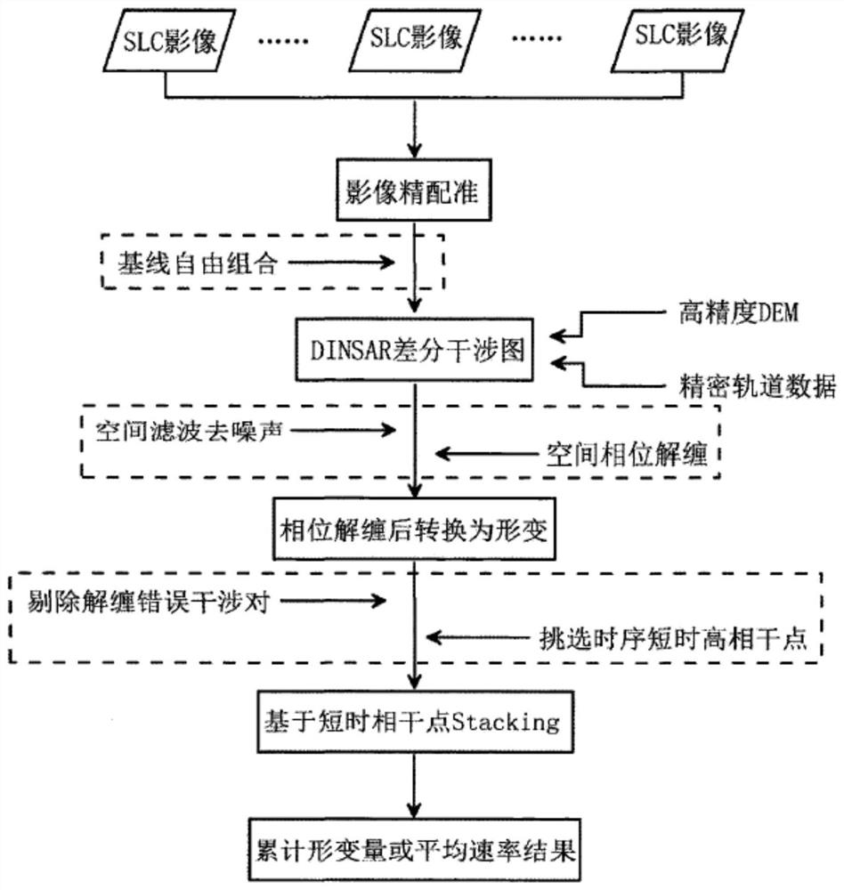
[0019] refer to figure 1 , figure 1 Flowchart showing the satellite interferometry method for seasonal deformation of permafrost; as figure 1 As shown, the method S includes steps S1 to S6.

[0020] In step S1, several SAR images of the seasonal deformation frost heaving / thawing subsidence stage of the permafrost area are obtained, and all SAR images are registered and then resampled to the same spatial coordinate system;...


PUM


Abstract

The invention discloses a satellite interference measurement method for frozen soil seasonal deformation. The satellite interference measurement method comprises the following steps of: registering SAR images of a frozen soil region and resampling the SAR images into the same space coordinate system; pairing the converted SAR images, and selecting interference pairs meeting set conditions for carrying out interference; removing a reference ellipsoid phase of each point in an interferogram by adopting precision orbit data, simulating a terrain phase by adopting a high-precision DEM, and removing a terrain phase of each point in the interferogram to obtain a differential interferogram; filtering the differential interferogram, carrying out phase unwrapping on the filtered interferogram by adopting a minimum cost flow method, and converting an unwrapping phase into surface deformation; acquiring the number of pixels exceeding a preset coherence coefficient in a interference pair time sequence, and selecting pixel points of which the number is greater than a preset number as short-time high coherence points; and according to the selected short-time high-coherence points, solving an average rate and cumulant of frozen soil seasonal deformation point by point by utilizing a Stacking method based on a linear model.

Description

technical field [0001] The invention relates to the technical field of research on seasonal deformation of frozen soil, in particular to a satellite interferometry method for seasonal deformation of frozen soil. Background technique [0002] With the global warming, the global permafrost is experiencing severe degradation, and the permafrost degradation problem facing the Qinghai-Tibet Plateau is even more serious. The degradation of permafrost on the plateau is mainly manifested in the increase of the average ground temperature, the reduction of the permafrost area, and the reduction of the active layer. Thickness increases and the lower limit of permafrost rises, etc. The degradation of permafrost has caused a series of natural disasters and ecological environment problems. In the context of global warming, as the permafrost melts, the carbohydrates contained in the permafrost may undergo a series of chemical reactions, and eventually be discharged into the atmosphere in ...

Claims


Application Information

Patent Timeline
Patent Type & Authority Applications(China)
IPC IPC(8): G01S13/90G01B15/06
CPCG01S13/9023G01B15/06
Inventor 刘国祥张瑞吴婷婷王晓文向卫
Owner SOUTHWEST JIAOTONG UNIV
Why Eureka
Try Eureka