A method for determining the position of the intersection of altimetry satellite trajectories based on the minimum distance method

A technology of intersection and distance method, applied in the field of aerospace surveying and mapping, can solve the problems of not being suitable for studying the exact position of the intersection of satellites, increasing the instability of calculation results, and unable to obtain the approximate position of the point, achieving reliable and simple implementation, Easy to achieve and stable effect

Active Publication Date: 2022-02-18
NAT MARINE DATA & INFORMATION SERVICE
View PDF3 Cites 0 Cited by
  • Summary
  • Abstract
  • Description
  • Claims
  • Application Information

AI Technical Summary

Problems solved by technology

Generally, the method of determining the intersection point of satellite orbits is the quadratic function fitting method, but the actual orbit of the satellite altimeter is quite different from the fitting curve of the quadratic function, especially in high latitude regions, the position of the approximate point cannot be obtained, Increased the instability of the calculation results
Using manual segmentation for quadratic fitting, although the exact position of the intersection point can be determined with high accuracy, but because the segmentation method changes with the change of satellite orbit inclination, it is not suitable for studying the accuracy of multi-generation satellite intersecting points. Location

Method used


Image

  • A method for determining the position of the intersection of altimetry satellite trajectories based on the minimum distance method
  • A method for determining the position of the intersection of altimetry satellite trajectories based on the minimum distance method
  • A method for determining the position of the intersection of altimetry satellite trajectories based on the minimum distance method

Examples


Embodiment Construction

[0040] The specific implementation of the technical solution will be described in detail below in conjunction with the accompanying drawings and the specific implementation.

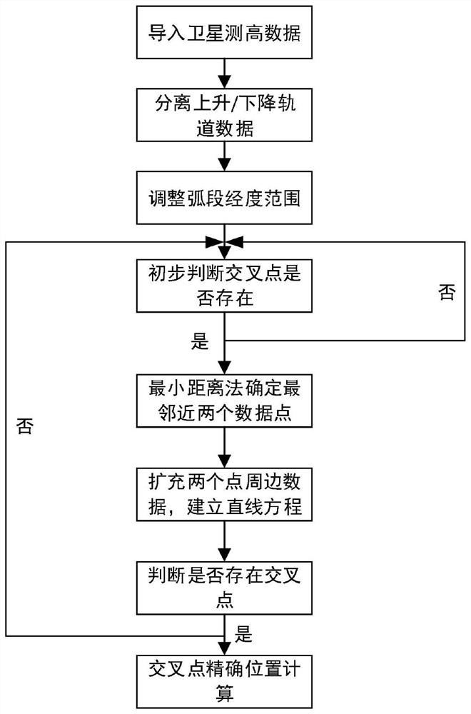
[0041] This patent algorithm is realized by compiling the matlab program, such as figure 1 shown, including the following steps:

[0042] 1. Import satellite altimetry data;

[0043] 2. Use the minimum latitude point to separate the ascending orbit data and descending orbit data, and adjust the longitude of the arc to -180°-360°;

[0044] 3. Preliminarily judge whether the intersection exists;

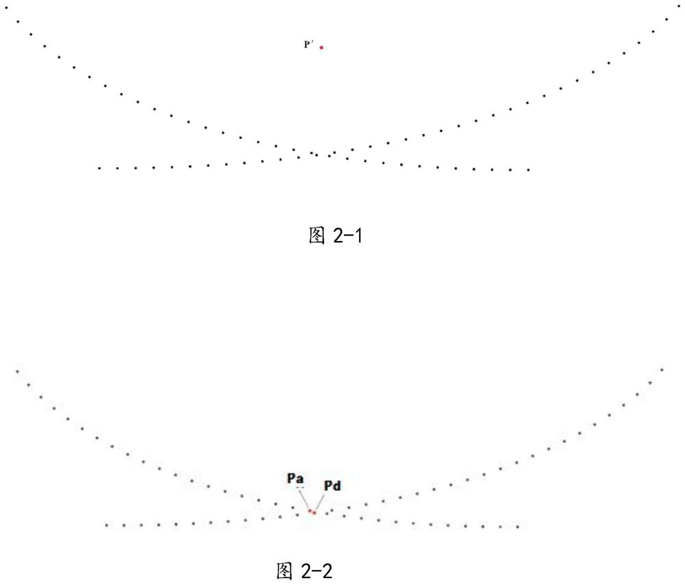
[0045] 4. Use the minimum distance method to obtain the two closest points of the ascending orbit and descending orbit, and take 5 data points before and after these two points to obtain two two-dimensional arrays;

[0046] 5. Connect the first and last points of the two arrays to obtain a straight line, and calculate the 4 data points near the intersection of the two straight lines;

[0047] 6. Use linear in...


PUM


Abstract

A method for determining the position of the intersection of altimetry satellite tracks based on the minimum distance method, comprising the following steps: ① import satellite altimetry data; ② use the minimum latitude point to separate ascending orbit data and descending orbit data, and adjust the longitude of the arc to ‑180° ‑360°; ③ preliminarily judge whether the intersection point exists; ④ use the minimum distance method to obtain the two points with the closest distance between the ascending orbit and the descending orbit, and take 5 data points before and after these two points to obtain two binary ⑤ The first and last two points of the two arrays are connected to obtain a straight line, and four data points near the intersection of the two-day straight line are obtained; ⑥ The latitude and longitude coordinates and elevation of the exact intersection point are obtained by linear interpolation. This method can accurately determine the position of the ground intersection of altimetry satellite orbits, ensure the stability of calculating the elevation change of the polar ice sheet, and is suitable for studying the exact position of the intersection of multi-generation satellites and high latitude regions.

Description

technical field [0001] The invention belongs to the field of aerospace surveying and mapping, and in particular relates to a method for determining the position of an intersection of altimetry satellite tracks based on a minimum distance method. Background technique [0002] When the altimetry satellite flies around the earth, it will form a satellite track on the ground. Generally, the track of the satellite moving from the southern hemisphere to the northern hemisphere is called the ascending pass, and the track of the satellite moving from the northern hemisphere to the southern hemisphere is called the descending track ( Descending pass), theoretically speaking, in a certain area, there will be intersection points where the ascending trajectory and descending trajectory of the altimetry satellite intersect. We can use the intersection points of the ascending trajectory and descending trajectory of the altimetry satellite in different periods The height change monitoring ...

Claims


Application Information

Patent Timeline
Patent Type & Authority Patents(China)
IPC IPC(8): G01C5/00G01C1/02
CPCG01C5/00G01C1/02
Inventor 郭灿文杨晓彤王朝阳杨慧贤孙毅马永邢喆赵现仁赵彬如樊妙
Owner NAT MARINE DATA & INFORMATION SERVICE
Why Eureka
Try Eureka