SAR data block adjustment processing method and system
A technology of area network adjustment and data area, which is applied in image data processing, radio wave measurement system, radio wave reflection/reradiation, etc. It can solve the problems of time-consuming and labor-intensive initial positioning accuracy of manual selection of control points
- Summary
- Abstract
- Description
- Claims
- Application Information
AI Technical Summary
Problems solved by technology
Method used
Image

Examples
Embodiment 1
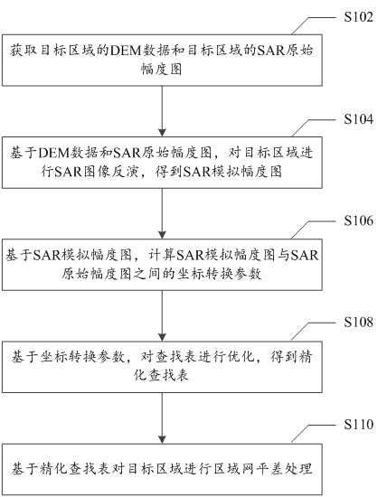
[0028] figure 1 It is a flow chart of a SAR data area network adjustment processing method provided according to an embodiment of the present invention. like figure 1 As shown, the method specifically includes the following steps:
[0029] Step S102, acquiring the DEM data of the target area and the SAR original amplitude map of the target area.
[0030] Optionally, the original SAR amplitude map can be obtained by performing multi-look and amplitude extraction on the SAR data of the target area.
[0031] Step S104, based on the DEM data and the original SAR amplitude map, perform SAR image inversion on the target area to obtain the SAR simulated amplitude map.
[0032]Step S106 , based on the SAR simulated magnitude map, calculating coordinate conversion parameters between the SAR simulated magnitude map and the SAR original magnitude map.
[0033] Step S108, optimize the lookup table based on the coordinate conversion parameters to obtain a refined lookup table; the look...
Embodiment 2
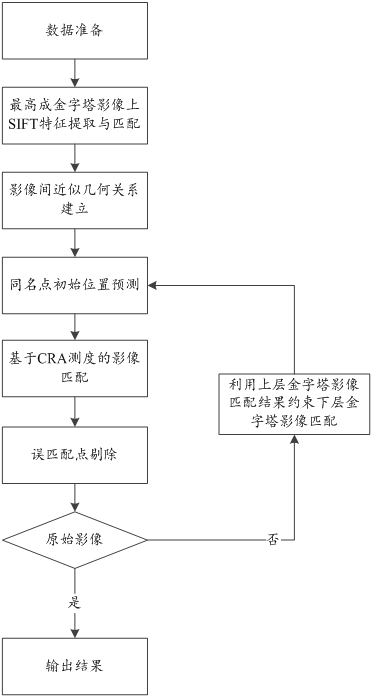
[0095] Figure 6 It is a flow chart of another SAR data area network adjustment processing method provided according to an embodiment of the present invention. like Figure 6 As shown, the method includes:
[0096] With the help of external DEM, using the initial orbital information and using simulation technology to generate SAR simulation images that fully reflect the characteristics of the surface terrain; specifically, the original SAR data is imported, multi-view and amplitude extraction are performed to obtain SAR amplitude maps, and geocoding Obtain the lookup table, and then obtain the SAR simulation amplitude map through the inversion of the external DEM data;
[0097] Then, the image matching method is used to automatically obtain the coordinate difference of the point with the same name between the simulated image and the real image, and optimize the initial geometric positioning results of the SAR data; specifically, by transforming the coordinates of the SAR sim...
Embodiment 3
[0102] Figure 7 It is a schematic diagram of a SAR data area network adjustment processing system provided according to an embodiment of the present invention. like Figure 7 As shown, the system includes: an acquisition module 10 , an inversion module 20 , a calculation module 30 , a registration module 40 and a processing module 50 .
[0103] Specifically, the acquiring module 10 is configured to acquire the DEM data of the target area and the SAR original amplitude map of the target area.
[0104] The inversion module 20 is configured to invert the SAR image of the target area based on the DEM data and the original SAR amplitude image to obtain the SAR simulated amplitude image.
[0105] The calculating module 30 is configured to calculate coordinate conversion parameters between the SAR simulated amplitude map and the SAR original amplitude map based on the SAR simulated amplitude map.
[0106] The registration module 40 is configured to register the look-up table base...
PUM
 Abstract
Description
Claims
Application Information
 - R&D
- Intellectual Property
- Life Sciences
- Materials
- Tech Scout
- Unparalleled Data Quality
- Higher Quality Content
- 60% Fewer Hallucinations
Browse by: Latest US Patents, China's latest patents, Technical Efficacy Thesaurus, Application Domain, Technology Topic, Popular Technical Reports.
© 2025 PatSnap. All rights reserved.Legal|Privacy policy|Modern Slavery Act Transparency Statement|Sitemap|About US| Contact US: help@patsnap.com