
An integrated navigation method for underwater vehicles based on mems IMU/magnetometer/DVL combination

A combined navigation and carrier technology, which is applied to navigation, navigation, ground navigation and other directions through velocity/acceleration measurement, can solve the problems of limited heading and attitude measurement accuracy, difficulty in accurate navigation of underwater carriers, and high price. The effect of improving the accuracy of navigation and positioning

Active Publication Date: 2022-07-05
NORTHWESTERN POLYTECHNICAL UNIV
View PDF5 Cites 0 Cited by
  • Summary
  • Abstract
  • Description
  • Claims
  • Application Information

AI Technical Summary

Problems solved by technology

Due to the particularity of the underwater environment, it is still difficult to achieve precise navigation of underwater vehicles. Navigation is one of the main technical challenges faced by underwater vehicles.
[0003] The current high-precision navigation system is mainly based on laser or optical fiber strapdown inertial navigation system, supplemented by GPS and DVL and other means. Such systems are generally large in size and expensive; considering the portability and economy of the system, based on The MEMS navigation and positioning system has the characteristics of small size and low cost, but the heading and attitude measurement accuracy under dynamic conditions is usually relatively limited. If the underwater vehicle is in a maneuvering state for a long time, the heading and attitude information obtained by the navigation system will have certain error

Method used


Image

  • An integrated navigation method for underwater vehicles based on mems IMU/magnetometer/DVL combination
  • An integrated navigation method for underwater vehicles based on mems IMU/magnetometer/DVL combination
  • An integrated navigation method for underwater vehicles based on mems IMU/magnetometer/DVL combination

Examples


Embodiment Construction

[0071] The embodiments of the present invention are described in detail below, and the embodiments are exemplary and intended to explain the present invention, but should not be construed as a limitation of the present invention.

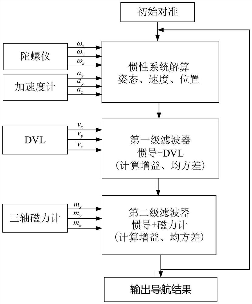
[0072] The invention proposes an integrated navigation method for underwater vehicles based on the combination of MEMS IMU / magnetometer / DVL, which includes an initial alignment process, an inertial calculation process, a velocity measurement Kalman filtering process and a heading measurement Kalman filtering process process. After the underwater carrier enters the water, the initial heading attitude of the underwater carrier is obtained by using the magnetometer and the accelerometer, and the initial alignment process is completed. Here, the satellite navigation data is introduced as the initial position of the inertial navigation recursive solution.

[0073] When the underwater vehicle is navigating underwater, the MEMS IMU / magnetometer / DVL combin...


PUM


Abstract

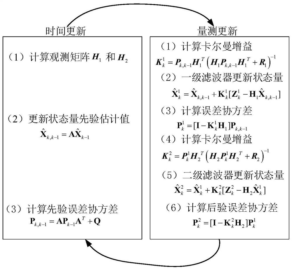
The invention proposes a combined navigation method for underwater vehicles based on the combination of MEMS IMU / magnetometer / DVL, which includes an initial alignment process, an inertial calculation process, a velocity measurement Kalman filter and a heading measurement Kalman filter. In the alignment process, the magnetometer and accelerometer are used to complete the initial heading and attitude calculation. In the inertial calculation process, the data of the MEMS IMU is used to perform the recursive calculation of the carrier pose. The velocity measurement Kalman filter is firstly calculated as the difference between the velocity output by the MEMS IMU and the DVL. The difference is measured once as a filter, and the navigation parameters such as heading and attitude are estimated by filtering, and the measurement accuracy of horizontal attitude is improved through feedback correction; secondly, the magnetic heading information and heading are calculated by combining the obtained horizontal attitude information and magnetometer measurement value. The measurement Kalman filter uses the difference between the heading and the magnetic heading obtained by the first feedback correction as the secondary measurement of the filter, and then performs filtering to obtain high-precision heading, attitude, speed and other navigation parameters, which greatly improves the positioning accuracy of the system. improve.

Description

technical field [0001] The invention relates to the technical field of navigation and positioning of underwater vehicles, in particular to a combined navigation method for underwater vehicles based on MEMS IMU / magnetometer / DVL combination. Navigation and positioning error of underwater navigation. Background technique [0002] The ocean is an important strategic space for human development, and realizing the rational and sustainable development and utilization of marine resources is crucial to the future development of human beings. The underwater carrier is currently the key equipment for ocean survey, marine resource exploration, underwater search and rescue, diving support, and military detectives. Due to the particularity of the underwater environment, it is still difficult to achieve accurate navigation of underwater vehicles. The navigation problem is one of the main technical challenges faced by underwater vehicles. [0003] The current high-precision navigation sys...

Claims


Application Information

Patent Timeline
Patent Type & Authority Patents(China)
IPC IPC(8): G01C21/16G01C21/18G01C21/20G01C21/04
CPCG01C21/165G01C21/18G01C21/04G01C21/203Y02A90/30
Inventor 张福斌廖伟飞潘光宋保维高剑
Owner NORTHWESTERN POLYTECHNICAL UNIV
Learn More