Land leveling method, system and device, equipment and storage medium

A land leveling and leveling technology, applied in the direction of soil preparation methods, soil lifting machinery, instruments, etc., can solve the problems of difficult preservation of topsoil on beams, difficult restoration of soil strength, uneven soil strength, etc., to achieve uniform and rapid land leveling operations, improve Accuracy, the effect of enhancing the effect

Active Publication Date: 2021-01-08
GUANGZHOU XAIRCRAFT TECH CO LTD
View PDF15 Cites 2 Cited by
  • Summary
  • Abstract
  • Description
  • Claims
  • Application Information

AI Technical Summary

Problems solved by technology

The disadvantage of the "grooving method" is that when the grooves are combined, the topsoil on the beams is not easy to preserve, resulting in uneven soil strength.
The "full shovel method" is suitable for mechanical leveling and has high work efficiency, but when there is a lot of raw soil, the soil force is not easy to recover

Method used


Image

  • Land leveling method, system and device, equipment and storage medium
  • Land leveling method, system and device, equipment and storage medium
  • Land leveling method, system and device, equipment and storage medium

Examples


Embodiment 1

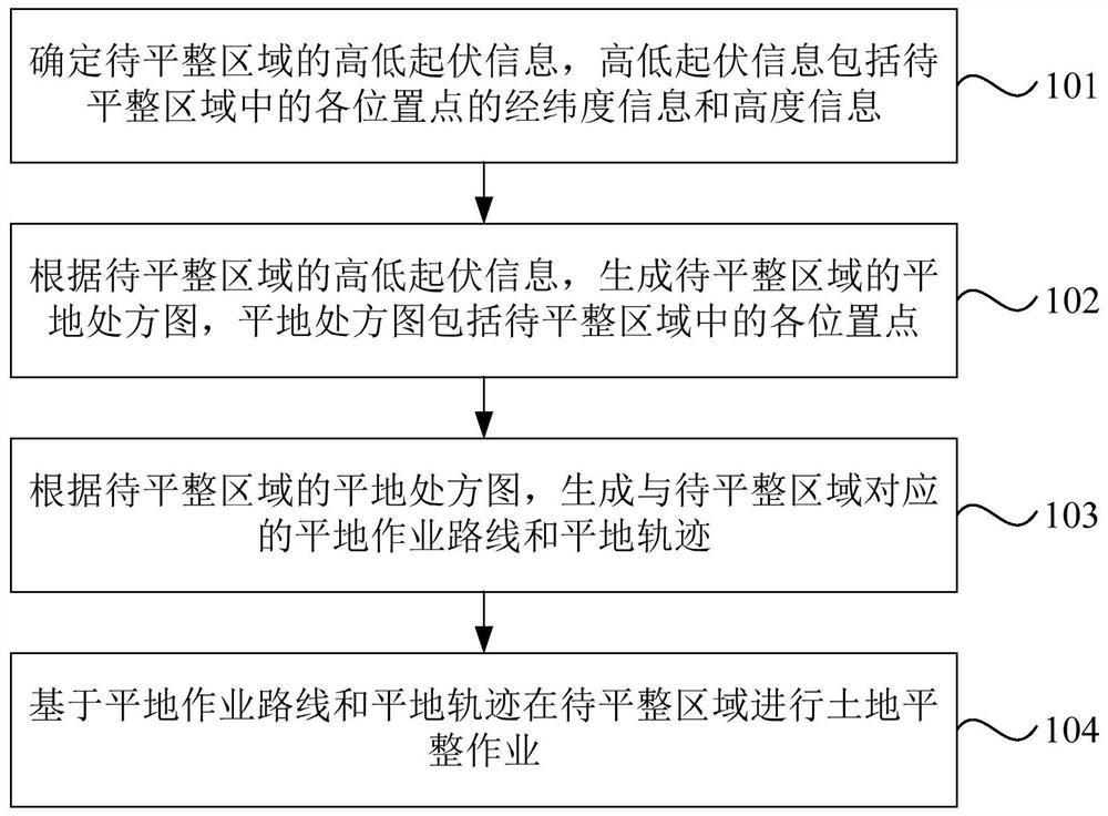
[0030] figure 1 It is a flow chart of a land leveling method provided by Embodiment 1 of the present invention. The embodiments of the present invention are applicable to the situation where land leveling operation is performed in the area to be leveled. The method can be executed by the land leveling device provided by the embodiment of the present invention, the device can be implemented in the form of software and / or hardware, and generally can be integrated into computer equipment. For example, in terminal equipment or in land leveling devices. Such as figure 1 As shown, the method of the embodiment of the present invention specifically includes:

[0031] Step 101. Determine the height and height information of the area to be leveled. The height and height information includes the latitude and longitude information and height information of each location point in the area to be leveled.

[0032] Optionally, determining the ups and downs information of the area to be le...

Embodiment 2

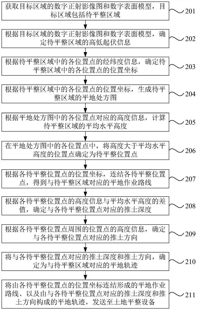
[0074] figure 2 It is a flow chart of a land leveling method provided by Embodiment 2 of the present invention. The embodiments of the present invention may be combined with various optional solutions in the foregoing one or more embodiments. Such as figure 2 As shown, the method of the embodiment of the present invention specifically includes:

[0075] Step 201 , acquiring a digital orthophoto image and a digital surface model of a target area, where the target area includes the area to be leveled.

[0076] Optionally, acquiring a digital orthophoto map and a digital surface model of the target area includes: acquiring image information collected by a surveying and mapping device in the target area; and generating a digital orthophoto map and a digital surface model of the target area according to the image information.

[0077] Step 202 , according to the digital orthophoto map and the digital surface model of the target area, determine the height and fluctuation inform...

Embodiment 3

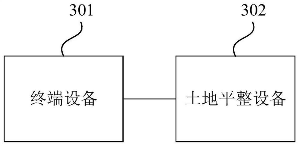
[0102] image 3 It is a schematic structural diagram of a land leveling system provided by Embodiment 3 of the present invention. Such as image 3 As shown, the system includes: a terminal device 301 and a land leveling device 302 .

[0103] Wherein, the terminal device 301 is used to determine the height and height information of the region to be leveled, and the height and height information includes the latitude and longitude information and height information of each position point in the region to be leveled; according to the height and height information of the region to be leveled, generate the height of the region to be leveled. Leveling prescription map, the leveling prescription map includes each position point in the area to be leveled; according to the leveling prescription map of the area to be leveled, generate the leveling operation route and leveling trajectory corresponding to the area to be leveled; send the leveling operation route and leveling trajectory t...


PUM


Abstract

The embodiment of the invention discloses a land leveling method, system and device, equipment and a storage medium. The method comprises the steps that fluctuation information of a to-be-leveled areais determined, and the fluctuation information comprises longitude and latitude information and height information of all position points in the to-be-leveled area; according to the fluctuation information of the to-be-leveled area, a land leveling prescription map of the to-be-leveled area is generated, and the land leveling prescription map comprises all the position points in the to-be-leveledarea; according to the land leveling prescription map of the to-be-leveled area, a land leveling operation route and a land leveling track corresponding to the to-be-leveled area are generated; and land leveling operation is carried out in the to-be-leveled area based on the land leveling operation route and the land leveling track. According to the land leveling method, system and device, the equipment and the storage medium, land leveling operation can be conveniently and accurately carried out in the to-be-leveled area according to the land leveling operation route and the land leveling track, the land leveling accuracy is improved, and the land leveling effect is improved.

Description

technical field [0001] Embodiments of the present invention relate to land leveling technology, in particular to a land leveling method, system, device, equipment and storage medium. Background technique [0002] At present, the land leveling method of farmland still adopts a more conventional method, using farmland basic construction machinery such as bulldozers, graders, scrapers, loaders, and excavators to perform leveling operations. But this can only achieve "rough flatness", that is, the so-called "field surface is flat, small unevenness". To sum up, there are roughly the following methods: "backward row method", "grooving method" and "full shovel method". [0003] The "backward row method" is a method of leveling the land that combines machinery and manpower. The operation is relatively delicate, which greatly affects the progress. The "grooving method" is also a method of leveling the land combining machinery and labor. It can open multiple grooves at the same time...

Claims


Application Information

Patent Timeline
Patent Type & Authority Applications(China)
IPC IPC(8): A01B79/00A01B77/00G06K9/00
CPCA01B79/00A01B77/00G06V20/10
Inventor 黄泽坛冼嘉晖
Owner GUANGZHOU XAIRCRAFT TECH CO LTD
Why Eureka
Try Eureka