UAV monitoring system for utility pole inclination based on synchronous positioning and mapping

A technology for synchronous positioning and utility poles, applied in the directions of measuring inclination, image analysis, image enhancement, etc., can solve the problems of low efficiency, low precision, high measurement cost and labor cost, etc., to reduce management costs, accurate monitoring, reduce The effect of labor costs and facility costs

Active Publication Date: 2021-04-16
SOUTH CHINA UNIV OF TECH +1
View PDF6 Cites 0 Cited by
  • Summary
  • Abstract
  • Description
  • Claims
  • Application Information

AI Technical Summary

Problems solved by technology

[0006] Aiming at the shortcomings of the existing technology, such as high measurement cost and labor cost, low precision and low efficiency, when measuring the inclination of utility poles, a UAV based on synchronous positioning and mapping is provided to monitor the inclination of utility poles. system

Method used


Image

  • UAV monitoring system for utility pole inclination based on synchronous positioning and mapping
  • UAV monitoring system for utility pole inclination based on synchronous positioning and mapping
  • UAV monitoring system for utility pole inclination based on synchronous positioning and mapping

Examples


Embodiment Construction

[0026] The content of the present invention will be further described below in conjunction with the accompanying drawings.

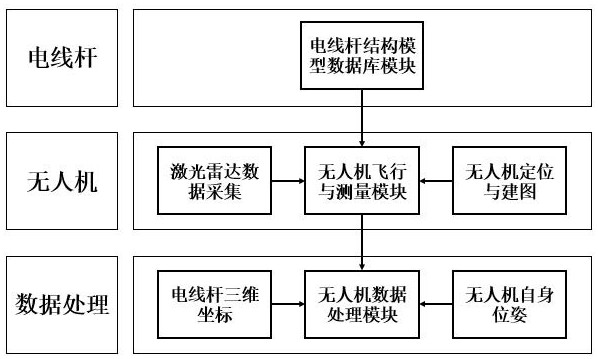
[0027] like figure 1 As shown, the UAV monitoring utility pole inclination system based on synchronous positioning and mapping described in the present invention is used to measure the inclination of utility poles, and specifically includes a utility pole structure model database module, unmanned aerial vehicle flying line and measurement module and UAV data processing module; the utility pole structure model database module is used to classify utility poles and construct corresponding utility pole mathematical structure models, and design the initial tour of unmanned aerial vehicles according to the utility pole mathematical structure models Line detection; the UAV flying line and measurement module are used to obtain the three-dimensional coordinate data of the utility pole and the pose data of the UAV and realize synchronous positioning and mapping fo...


PUM


Abstract

The invention relates to the field of unmanned aerial vehicle (UAV) measurement, in particular, the use of unmanned aerial vehicles to measure the inclination of utility poles, and specifically provides a system for monitoring the inclination of utility poles by unmanned aerial vehicles based on synchronous positioning and mapping. The system includes a utility pole structure model database module, a UAV flying line and measurement module, and a UAV data processing module. According to the three-dimensional coordinate data of the utility pole and the pose data of the drone, the central axis of the utility pole is fitted and Calculate the inclination of the utility pole. The invention can monitor the situation of the utility pole in real time, improve the monitoring efficiency to the greatest extent, reduce the labor cost and facility cost of monitoring, and can also realize the measurement of the inclination of the utility pole in an unknown environment and without a positioning system, ensuring more Intelligent, efficient and accurate monitoring of utility poles, quickly find hidden utility poles and notify them, and strengthen intelligent maintenance and inspection work; it has the advantages of accuracy, stability, ease of use and functionality.

Description

technical field [0001] The invention relates to the field of unmanned aerial vehicle measurement, in particular, the use of unmanned aerial vehicles to measure the inclination of electric poles, and specifically provides a system for monitoring the inclination of electric poles by unmanned aerial vehicles based on synchronous positioning and mapping (SLAM). Background technique [0002] Telephone poles are poles used to erect wires in power lines, such as cylindrical wooden poles, cylindrical cement poles, and tapered cement poles. The verticality of utility poles plays a very important role in the normal, safe and reliable operation of power lines. Therefore, it is necessary to measure the inclination of the utility pole during construction and installation and during a certain period of operation. [0003] Most of the existing methods for measuring the inclination of utility poles are still in the manual stage, such as instrument-based theodolite measurement methods, plane...

Claims


Application Information

Patent Timeline
Patent Type & Authority Patents(China)
IPC IPC(8): G06T7/70G06T7/68G06T7/00G06F16/29G06F16/906G06Q10/00G06Q50/06G01C9/00
CPCG01C9/00G06Q10/20G06Q50/06G06T7/0004G06T2207/30132G06T2207/30161G06T7/68G06T7/70G06F16/29G06F16/906
Inventor 柯峰谭咏雯彭陶峰柯永达敬伟
Owner SOUTH CHINA UNIV OF TECH
Why Eureka
Try Eureka