Road boundary remote measurement recognition algorithm adopting artificial neural network technology

A recognition algorithm and artificial nerve technology, applied in the field of road telemetry data analysis, can solve the problems of lack of non-artificial determination of road boundaries, lack of artificial intelligence technology, lack of solutions to determine road boundaries by telemetry data, etc. and maintenance, saving human resources, shortening the effect of measurement and calculation time

Inactive Publication Date: 2021-01-26
HUZHOU TEACHERS COLLEGE
View PDF0 Cites 0 Cited by
  • Summary
  • Abstract
  • Description
  • Claims
  • Application Information

AI Technical Summary

Problems solved by technology

[0003] 1. Lack of non-artificial determination of road boundaries
[0004] 2. Lack of solutions for determining road boundaries through telemetry data
[0005] 3....

Method used


Image

  • Road boundary remote measurement recognition algorithm adopting artificial neural network technology
  • Road boundary remote measurement recognition algorithm adopting artificial neural network technology
  • Road boundary remote measurement recognition algorithm adopting artificial neural network technology

Examples


Embodiment Construction

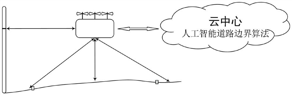
[0026] refer to figure 1 It is a structural schematic diagram of the system adopted in the present invention, mainly including a road boundary telemetry recognition algorithm set in the cloud center and a data telemetry system operating on site.

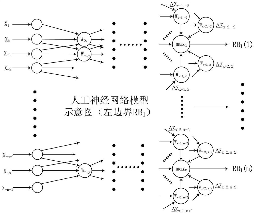
[0027] refer to figure 2 , image 3 The road boundary telemetry recognition algorithm adopting the artificial neural network technology in the present invention is a calculation method for calculating, reasoning and analyzing on-site telemetry data.

[0028] On-site telemetry data is that the UAV flies vertically according to the designed trajectory above the relevant road, and the scanning probe scans the ground horizontally through laser, ultrasonic or other radio waves (at the same road track point, the probe swings to scan the ground), and the obtained The distance information between the UAV and the ground scanning point.

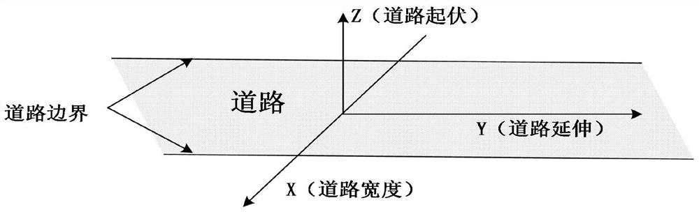
[0029] The calculation method is to first set the three-dimensional coordinate system (such as figur...


PUM


Abstract

The invention provides a road boundary remote measurement recognition algorithm adopting an artificial neural network technology. The algorithm specifically comprises the following steps of S1, acquiring the distance information between a scanning probe and a ground scanning point; S2, defining the longitudinal track of the scanning probe as a y axis, defining the transverse scanning of the groundas an x axis, and defining the height difference between ground scanning points as a z axis; S3, solving a corresponding x point position closest to a boundary according to the change trend of the height difference of adjacent points on the z axis and the position where mutation is generated through the reasoning calculation of adjacent dot matrixes of different x line points of the same point onthe y axis, finding a series of x points along with the change of the y value, and determining the initial value of the road boundary; and S4, performing smooth analysis and correction on the road boundary initial value to obtain an effective road boundary based on x and y coordinates. According to the present invention, the purpose of automatically giving the boundary of road measurement can beachieved, and a scientific basis is provided for determining the flatness and area of a road surface and the calculation range of other parameters.

Description

【Technical field】 [0001] The invention relates to the technical field of road telemetry data analysis, in particular to a road boundary telemetry recognition algorithm using artificial neural network technology, more specifically, through artificial intelligence neural network technology, the road telemetry data is analyzed to automatically determine the road The purpose of the efficient frontier. 【Background technique】 [0002] The current method of determining road boundaries has the following deficiencies: [0003] 1. There is a lack of solutions for non-manual determination of road boundaries. [0004] 2. There is a lack of solutions for determining road boundaries through telemetry data. [0005] 3. There is no artificial intelligence technology, which can automatically determine the executable plan of the road boundary through the analysis of telemetry data. 【Content of invention】 [0006] The purpose of the present invention is to solve the problems in the prior ...

Claims


Application Information

Patent Timeline
IPC IPC(8): G06T7/181G06T7/62G06N3/04
CPCG06N3/04G06T2207/10032G06T2207/20084G06T7/181G06T7/62
Inventor 周芦慧肖良军刘利民
Owner HUZHOU TEACHERS COLLEGE
Why Eureka
Try Eureka