A Road Extraction Method Based on Multi-branch Pyramid Neural Network for Remote Sensing Image

A remote sensing image and neural network technology, applied in the field of geographic information systems, can solve problems such as sparse roads and broken roads, and achieve the effects of enhancing reasoning ability, improving accuracy, and ensuring connectivity and integrity

Active Publication Date: 2022-06-07
WUHAN UNIV
View PDF5 Cites 0 Cited by
  • Summary
  • Abstract
  • Description
  • Claims
  • Application Information

AI Technical Summary

Problems solved by technology

The technical solution adopted by the present invention is to use deep learning technology to construct a multi-branch pyramid neural network, and to solve the problem of road extraction on satellite images through two parallel feature recovery structures and post-processing technology based on geometric structure analysis and feature point extraction. The problem of road sparsity and road breakage caused by vegetation and buildings

Method used


Image

  • A Road Extraction Method Based on Multi-branch Pyramid Neural Network for Remote Sensing Image
  • A Road Extraction Method Based on Multi-branch Pyramid Neural Network for Remote Sensing Image
  • A Road Extraction Method Based on Multi-branch Pyramid Neural Network for Remote Sensing Image

Examples


Embodiment Construction

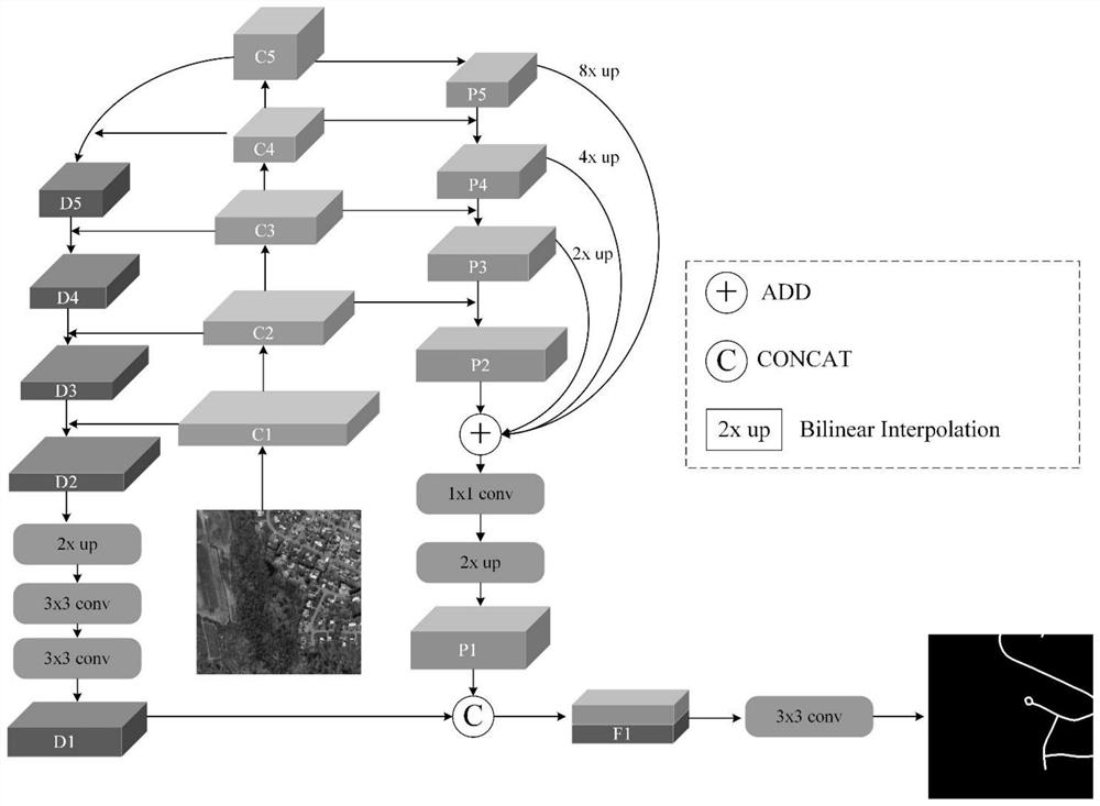
[0040] In order to make the objectives, technical solutions and advantages of the present invention clearer, the present invention will be further described in detail below with reference to the accompanying drawings and embodiments. It should be understood that the specific implementations described herein are intended to help better understand the content of the method of the present invention, but these specific implementations do not limit the protection scope of the present invention in any way.

[0041] The example data of the present invention is Massachusetts Roads Dataset, the neural network construction tool is Pytorch, and the programming language is Python. The specific implementation process steps are as follows:

[0042] Step 1, according to the actual business requirements, select Massachusetts Roads Dataset (hereinafter referred to as MRD) as the neural network test data set. The dataset is aerial imagery covering urban, suburban and rural areas in Massachuset...


PUM


Abstract

The invention discloses a method for extracting complete road information on remote sensing images by using a convolutional neural network. A multi-branch pyramidal neural network is constructed. Through two parallel feature recovery structures and post-processing technology based on geometric structure analysis and feature point extraction, the low-level position information and high-level semantic information are fully mined to solve the problem of road extraction on satellite images. The problem of road sparsity and road breakage caused by vegetation and buildings are faced. This method comprehensively considers the sparsity of road distribution and the imbalance of samples through sparsity testing and designing a new loss function, so that the network pays more attention to sparse and difficult-to-classify road pixels. At the same time, in view of the situation where the road is covered by vegetation and buildings, this method performs automatic fracture detection and fracture connection based on geometric feature point analysis, which improves the accuracy of road extraction, and has an important role in computer vision and remote sensing road extraction scenarios. practical application value.

Description

technical field [0001] The method of the invention belongs to the field of geographic information system and computer vision, and particularly relates to extracting road information on remote sensing images by using a convolutional neural network. Background technique [0002] As an important basic geographic information data, roads play an important role in urban planning, transportation and logistics, emergency and disaster relief, and travel navigation. At present, the extraction and update of road information mainly include the following: (1) traditional surveying and mapping methods: relying on manual field measurement and recording; (2) road extraction based on GPS trajectory: collecting vehicles, taxis and People's travel trajectories to analyze road information. The above two methods require a lot of manpower and material resources, take a long time to collect data in the early stage, and have a long period of extraction and update of the entire road information, wh...

Claims


Application Information

Patent Timeline
Patent Type & Authority Patents(China)
IPC IPC(8): G06V20/10G06V20/13G06V10/26G06V10/44G06V10/80G06V10/82G06K9/62G06N3/04
CPCG06V20/176G06V20/188G06V20/182G06V10/267G06V10/44G06N3/048G06N3/045G06F18/253Y02T10/40
Inventor 张文李俊杰孟诣卓顿玉多吉魏晓冰张志远
Owner WUHAN UNIV
Why Eureka
Try Eureka