Visual synthesis method and system based on low-power-consumption hardware platform

A technology of a hardware platform and a synthesis method, which is applied in the processing of 3D images, details involving 3D image data, processor architecture/configuration, etc., to achieve the effect of improving loading speed, improving frame rate, and reducing performance consumption

Active Publication Date: 2021-02-05
CHENGDU ZIRUI QINGYUN AEROSPACE TECH CO LTD +1
View PDF6 Cites 3 Cited by
  • Summary
  • Abstract
  • Description
  • Claims
  • Application Information

AI Technical Summary

Problems solved by technology

[0005] The purpose of the present invention is to overcome the problem that the synthetic vision system in the prior art requires the support of electronic equipment with higher rendering performance, but the electronic equipment with higher performance does not meet the needs of the aviation field for

Method used


Image

  • Visual synthesis method and system based on low-power-consumption hardware platform
  • Visual synthesis method and system based on low-power-consumption hardware platform
  • Visual synthesis method and system based on low-power-consumption hardware platform

Examples


Embodiment 1

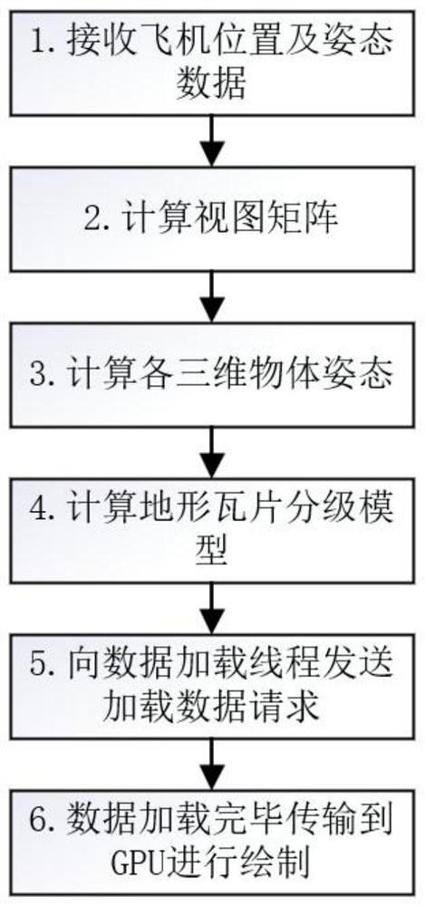
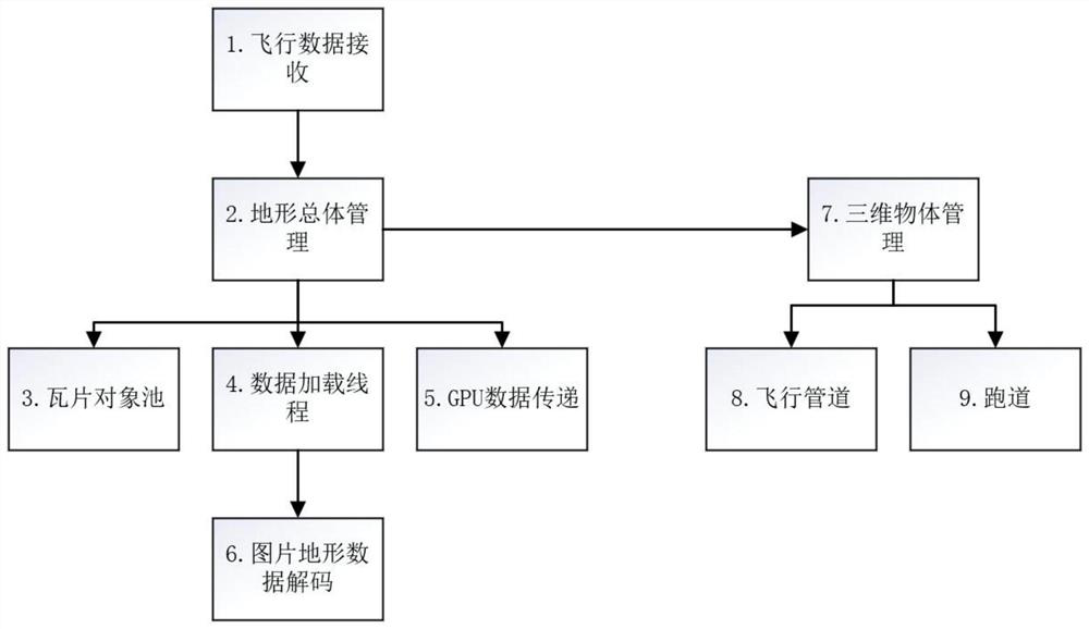
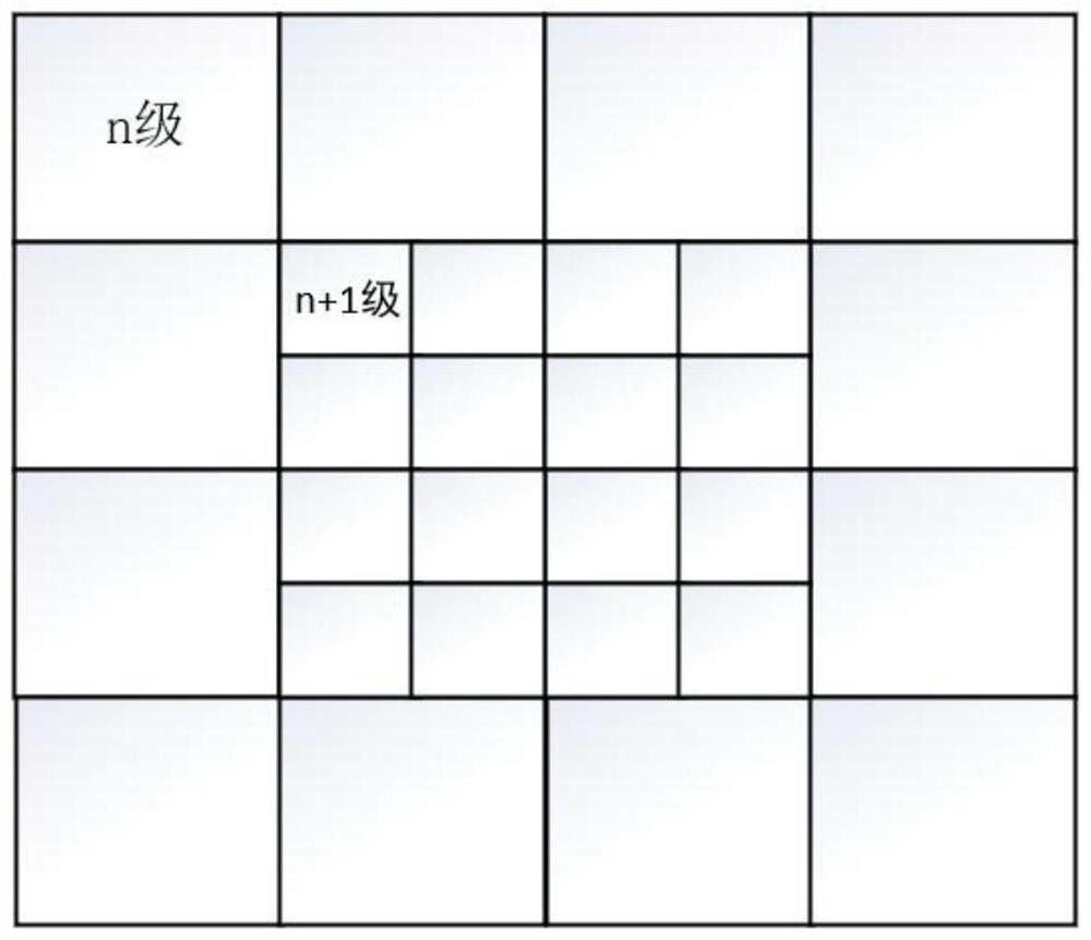
[0042] figure 1 Shows a schematic flow chart of a method for scene synthesis based on a low-power hardware platform according to an embodiment of the present invention, including: A, receiving aircraft flight status data and first satellite image data, the flight status data including: aircraft position data and aircraft attitude data; B, determine the three-dimensional view matrix according to the flight state data, the three-dimensional view matrix includes: aircraft matrix, flight pipeline matrix and runway matrix; C, establish the relative position coordinates of terrain tiles according to the aircraft position data system; determine the current terrain tile level from the preset terrain tile classification model according to the aircraft position data, select the corresponding terrain tile according to the current terrain tile level, and set the relative position coordinate system of the terrain tile Calculate the selected terrain tiles to obtain the first terrain tile da...

Embodiment 2

[0060] Specifically, select I.MX6Q as the low power consumption hardware platform of the present invention. NXP's I.MX6Q is a processor widely used in many fields such as consumer electronics, industry and in-vehicle entertainment. Based on ARM CortexTM-A9 architecture, 40nm process, GPU computing power 16 GFLOPS, full load power consumption 7.6W. Automotive grade operating temperature can reach -40° to +125°.


PUM


Abstract

The invention discloses a visual synthesis method and system based on a low-power-consumption hardware platform. The method comprises determining a terrain tile level through a preset terrain tile grading model and based on the ground clearance of an airplane, thereby calculating terrain tile data according to the level. The method is capable of reducing the number of tiles participating in subsequent calculation and final rendering, reducing performance consumption and increasing frame rate; in addition, the problem of flicker at the tile boundary due to insufficient vertex depth value precision is solved through a method of converting world coordinates into relative coordinates; and a specific satellite image data storage format is adopted, so that the loading speed can be increased whenthe satellite image data is loaded. The system can smoothly operate the synthetic vision system under the low-power hardware platform, can flexibly configure the terrain rendering precision in the synthetic vision and the number of three-dimensional objects in the scene according to different application scenes and requirements, and adapts to the rendering performance of different low-power hardware platforms.

Description

technical field [0001] The invention relates to the technical field of display and control of avionics equipment, in particular to a scene synthesis method and system based on a low-power consumption hardware platform. Background technique [0002] With the rapid development of computer technology, synthetic vision system is playing an increasingly important role in the field of flight. Synthetic vision systems use information such as terrain, obstacles, runways, and satellite images to render a computer-built view of the terrain outside the aircraft. Key features of the aircraft's external terrain environment are shown to the pilot. Ability to reduce aircraft accidents due to low visibility environments. The pilot's vision is not affected by the visibility of the real external environment, which improves flight safety and reduces the burden on the pilot. It only needs precise positioning information and terrain mapping information, and is not affected by environmental vi...

Claims


Application Information

Patent Timeline
IPC IPC(8): G06T17/00G06T15/00G06T1/20
CPCG06T17/00G06T15/005G06T1/20G06T2200/04
Inventor 唐太虎张松江彦肖永红杨阳缪国凯
Owner CHENGDU ZIRUI QINGYUN AEROSPACE TECH CO LTD
Why Eureka
Try Eureka