Urban high-precision three-dimensional terrain construction method and system based on LiDAR point cloud data

A technology of 3D terrain and point cloud data, applied in 3D modeling, image data processing, neural learning methods, etc., can solve the problems of high update cost, lack of sponge city, poor current situation, etc., to improve accuracy and refinement. Effect

Pending Publication Date: 2021-02-09
南通市测绘院有限公司
View PDF0 Cites 8 Cited by
  • Summary
  • Abstract
  • Description
  • Claims
  • Application Information

AI Technical Summary

Problems solved by technology

The existing urban DEM data production technology is designed for natural terrain, and the 3D terrain data is mainly 1:2000 to 1:500 DEM, and the current situation is poor, and the update cost is high
The current application of high-precision 3D terrain in cities has the following deficiencies: (1) It is difficult to meet the needs of sponge city planning. Sponge city construction requires accurate 3D terrain to divide catchment areas and calculate the direction of surface runoff, and then calculate confluence and yield. , a

Method used


Image

  • Urban high-precision three-dimensional terrain construction method and system based on LiDAR point cloud data
  • Urban high-precision three-dimensional terrain construction method and system based on LiDAR point cloud data
  • Urban high-precision three-dimensional terrain construction method and system based on LiDAR point cloud data

Examples


Embodiment Construction

[0047] In order to make it easier for those skilled in the art to understand and implement the present invention, the present invention will be further described in detail below in conjunction with the accompanying drawings and specific embodiments. It should be understood that the implementation examples described here are only used to illustrate and explain the present invention, and are not intended to limit the present invention.

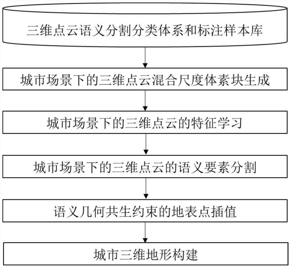
[0048] LiDAR stands for LiDAR. The point cloud data obtained by LiDAR has high measurement accuracy and can provide high-precision surface elevation information, spatial information, and echo intensity information that are not limited by shadow and light conditions. Based on LiDAR data, the patent of the present invention proposes a method for constructing urban high-precision three-dimensional terrain, so that the accuracy of urban three-dimensional terrain data can meet the application requirements of sponge city construction and urban waterlo...


PUM


Abstract

The invention provides an urban high-precision three-dimensional terrain construction method and system based on LiDAR point cloud data. The urban high-precision three-dimensional terrain constructionmethod comprises the steps of creating a three-dimensional point cloud semantic segmentation classification system and a labeling sample library in an urban scene; establishing a three-dimensional point cloud mixed scale voxel block in an urban scene; realizing feature learning of the three-dimensional point cloud, including for a plurality of divided mixed scales, fusing detail structures of thethree-dimensional point cloud and surrounding surface background information by using a three-dimensional convolutional network with a plurality of shared weights to obtain a mixed scale feature vector of the three-dimensional point cloud; realizing semantic element segmentation of the three-dimensional point cloud, including training a feature learning network and performing reasoning predictionon the three-dimensional point cloud of a to-be-modeled area; realizing surface point interpolation of semantic and geometric symbiotic constraints, and making up holes caused by non-surface points to be filtered; and constructing an urban three-dimensional terrain model. According to the method, the semantic segmentation result precision and the precision degree of the urban three-dimensional terrain are improved, and the application requirements of sponge city construction, urban inland inundation analysis and the like are met.

Description

technical field [0001] The invention belongs to the technical field of terrain surveying and mapping, and in particular relates to a method and system for constructing urban high-precision three-dimensional terrain based on LiDAR point cloud data. Background technique [0002] A city is a blend of natural terrain and artificial terrain, and urban areas usually present a state of interlaced abrupt terrain and gradual terrain. The existing urban DEM data production technology is designed for natural terrain, and the 3D terrain data is mainly 1:2000 to 1:500 DEM, and the current situation is poor, and the update cost is high. The current application of high-precision 3D terrain in cities has the following deficiencies: (1) It is difficult to meet the needs of sponge city planning. Sponge city construction requires accurate 3D terrain to divide catchment areas and calculate the direction of surface runoff, and then calculate confluence and yield. , and urban gradient terrain ca...

Claims


Application Information

Patent Timeline
IPC IPC(8): G06T7/521G06T17/05G06T17/20G06N3/04G06N3/08
CPCG06T7/521G06T17/05G06T17/20G06N3/08G06T2200/08G06T2207/10028G06T2207/20081G06T2207/20084G06N3/048G06N3/045
Inventor 曹冬梅王晓利龚天宇
Owner 南通市测绘院有限公司
Why Eureka
Try Eureka