Vehicle driving blind area calibration method, device and equipment and storage medium

A vehicle driving and calibration method technology, applied in the field of vehicle navigation, can solve the problems of lack of validity of data, poor positioning accuracy, and high cost

Active Publication Date: 2021-02-19
DONGFENG MOTOR CORP HUBEI
View PDF10 Cites 3 Cited by
  • Summary
  • Abstract
  • Description
  • Claims
  • Application Information

AI Technical Summary

Problems solved by technology

[0004] The main purpose of the present invention is to provide a vehicle driving blind spot calibration method, device, equipment and storage medium, aiming to solve the problem of relying on peripheral communication infrastructure in the prior art, High cost, lack of validity of data, leading to technical problems of poor positioning accuracy

Method used


Image

  • Vehicle driving blind area calibration method, device and equipment and storage medium
  • Vehicle driving blind area calibration method, device and equipment and storage medium
  • Vehicle driving blind area calibration method, device and equipment and storage medium

Examples


Embodiment Construction

[0056] It should be understood that the specific embodiments described here are only used to explain the present invention, not to limit the present invention.

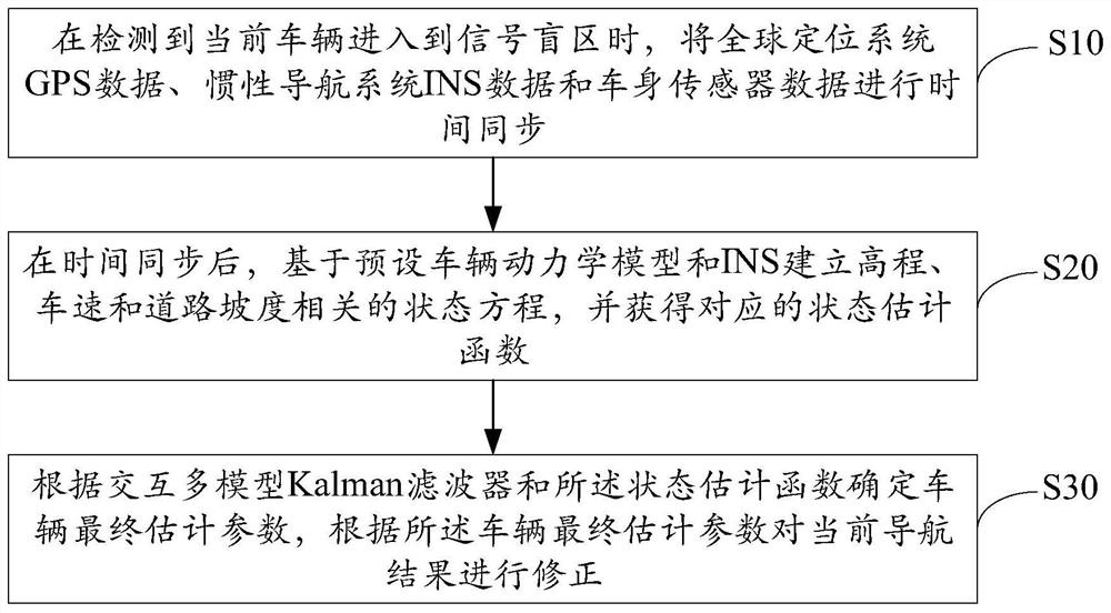
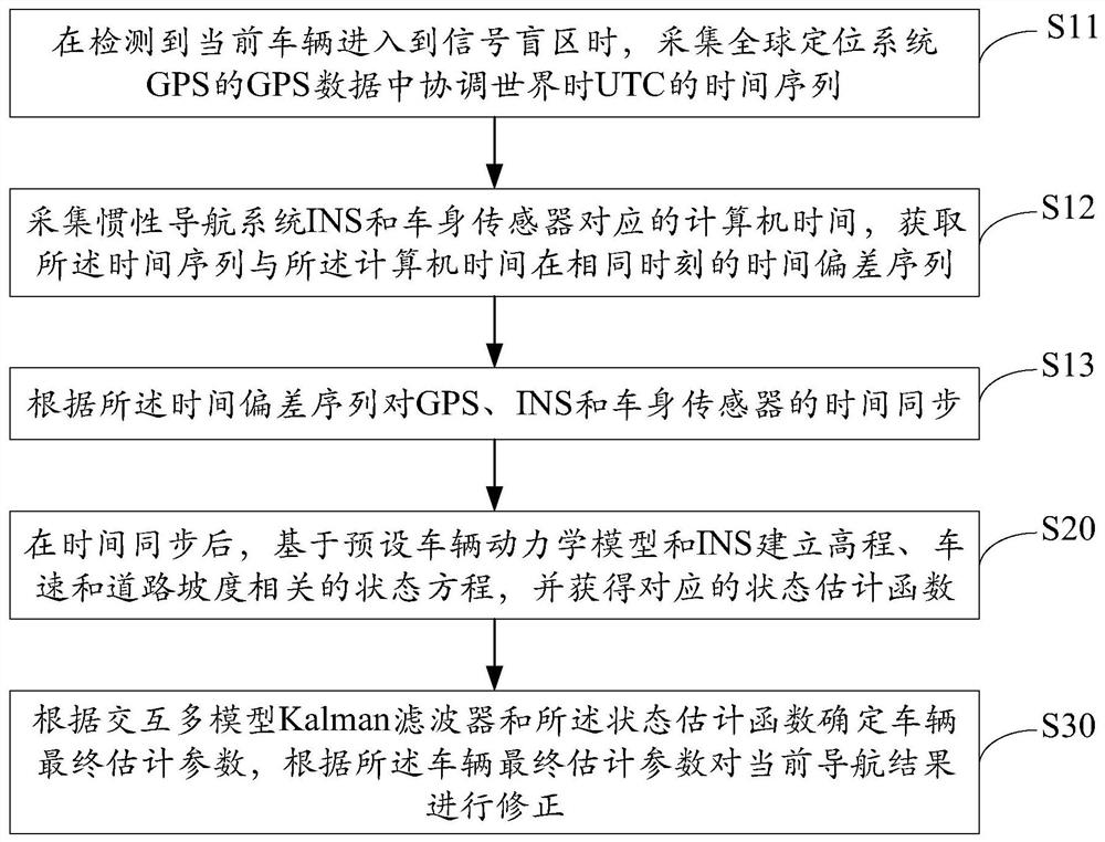
[0057] The solution of the embodiment of the present invention is mainly: when the current vehicle is detected to enter the signal blind zone, the GPS data of the global positioning system, the INS data of the inertial navigation system and the data of the vehicle body sensor are time-synchronized; The vehicle dynamics model and INS establish the state equations related to elevation, vehicle speed and road gradient, and obtain the corresponding state estimation function; determine the final estimation parameters of the vehicle according to the interactive multi-model Kalman filter and the state estimation function, and according to the final vehicle The estimated parameters correct the current navigation results, and the elevation signal can be corrected without being affected by the external environment, and the trans...


PUM


Abstract

The invention discloses a vehicle driving blind area calibration method, device and equipment and a storage medium. The method comprises the steps: carrying out time synchronization on global positionsystem (GPS) data, inertial navigation system (INS) data and vehicle body sensor data when a current vehicle is detected to enter a signal blind area; after time synchronization, establishing a stateequation related to elevation, vehicle speed and road gradient based on a preset vehicle dynamics model and INS, and obtaining a corresponding state estimation function; and determining the final estimation parameters of the vehicle according to an interactive multi-model Kalman filter and a state estimation function, and correcting the current navigation result according to the final estimationparameters of the vehicle, so that the problem of signal drift of the inertial navigation system in a blind area for a long time is avoided, the estimation precision and time precision of the navigation estimation result are ensured, the navigation correction data has real-time performance and effectiveness, the vehicle navigation precision is improved, the implementation cost is low, and extra infrastructure does not need to be built.

Description

technical field [0001] The present invention relates to the technical field of vehicle navigation, in particular to a method, device, equipment and storage medium for calibrating blind spots of vehicles. Background technique [0002] With the acceleration of the urbanization process, more and more high-rise buildings and three-dimensional traffic began to appear, which also brought more signal blind spots for GPS positioning and navigation vehicles. When a vehicle using GPS positioning and navigation passes through some viaducts and other three-dimensional intersections, the GPS receiver cannot receive satellite signals or the quality of the received signal is poor; even for the high-precision INS-GPS integrated navigation and positioning method, if the In the case of buildings, viaducts, etc. blocking GPS signals, inertial navigation can only be used to correct the positioning results; inertial navigation equipment will inevitably have cumulative errors over a long period o...

Claims


Application Information

Patent Timeline
Patent Type & Authority Applications(China)
IPC IPC(8): G01C21/28G01C21/16G01C21/20
CPCG01C21/28G01C21/165G01C21/20Y02T10/40
Inventor 裴双红赖锋陈振飞程梁柱肖松
Owner DONGFENG MOTOR CORP HUBEI
Why Eureka
Try Eureka