Vehicle-mounted laser point cloud and sequence panoramic image registration method

A panoramic image and vehicle-mounted laser technology, applied in the field of surveying and mapping, can solve problems such as limited algorithm adaptability, high approximation requirements, and difficulty in ensuring convergence

Inactive Publication Date: 2021-03-09
WUHAN UNIV
View PDF4 Cites 4 Cited by
  • Summary
  • Abstract
  • Description
  • Claims
  • Application Information

AI Technical Summary

Problems solved by technology

This type of method uses the output value of the POS system as the initial registration, and uses the non-rigid closest point iterative method to realize the registration of the two, but the iterative closest point (ICP) method has higher requir...

Method used


Image

  • Vehicle-mounted laser point cloud and sequence panoramic image registration method
  • Vehicle-mounted laser point cloud and sequence panoramic image registration method
  • Vehicle-mounted laser point cloud and sequence panoramic image registration method

Examples


Embodiment Construction

[0039] In order to better understand the above technical solution, the above-described technical scheme will be described in detail below in conjunction with the drawings and specific embodiments.

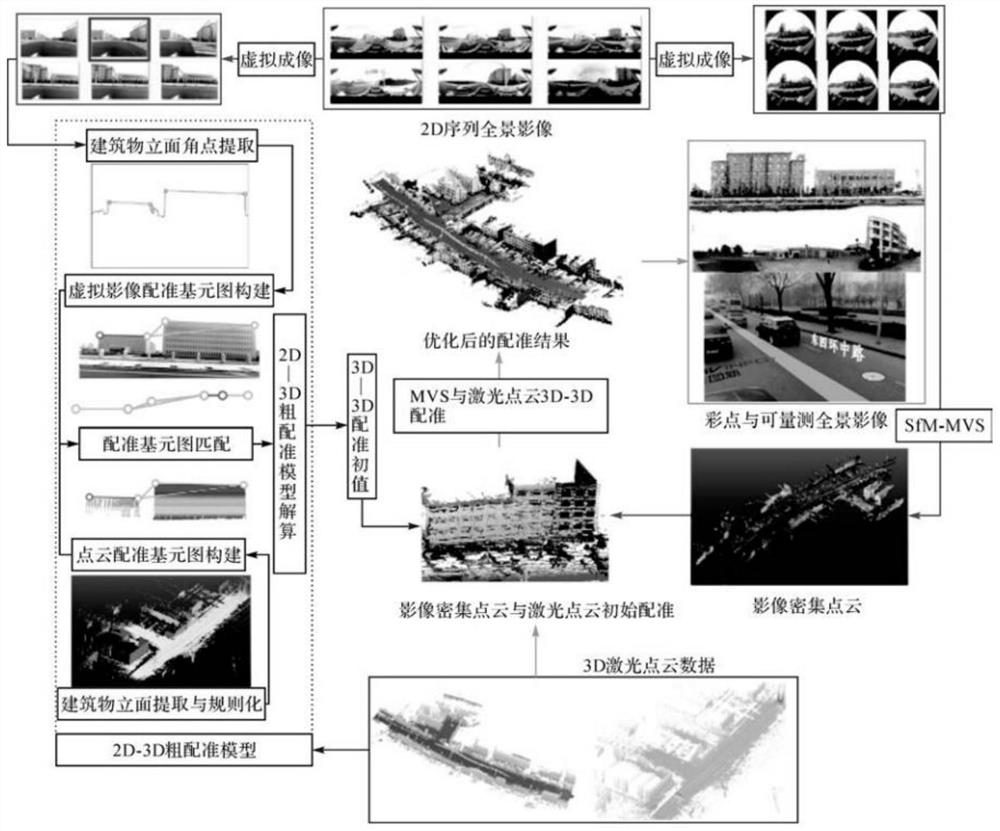
[0040] This embodiment provides a method of registration of a vehicle laser point cloud and sequence panoramic image, such as figure 2 As shown, it mainly includes the following steps:

[0041] Step 1, the registration element extraction.

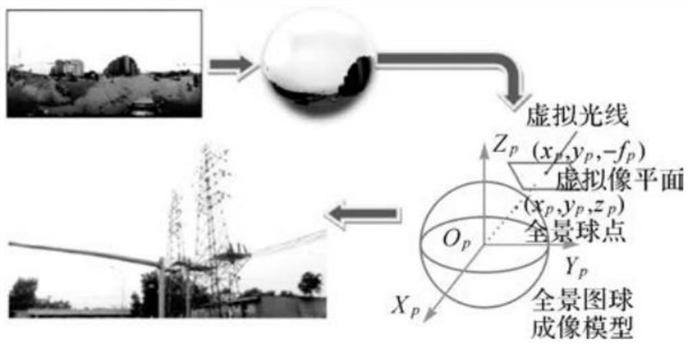
[0042] Select the skyline (building upper side) as a registration primitive, using a hierarchical city market target extraction method to extract the building facade and regularize the first day of the first day in the vehicle laser point cloud (ie, Lidar Point Cloud). In sequence panorama, through the virtual imaging method, the panoramic image of the spherical expansion imaging model is converted into a frame image, and the Grabcut algorithm is combined on the virtual image and the arc to the arc to the distance cumulative angular point detection...


PUM


Abstract

The invention belongs to the technical field of surveying and mapping, and discloses a vehicle-mounted laser point cloud and sequence panoramic image registration method, which comprises the steps ofobtaining vehicle-mounted laser point cloud data and sequence panoramic image data, and obtaining a first skyline vector and a second skyline vector; respectively constructing a laser point cloud registration primitive graph and an image registration primitive graph; forming a conjugate registration primitive pair; resolving a pre-established 2D-3D coarse registration model by using the conjugateregistration primitive pair to obtain space coordinate initial conversion parameter information between a photogrammetric coordinate system and a LiDAR reference coordinate system, and completing 2D-3D coarse registration; generating an MVS image dense point cloud based on the sequence panoramic image data; and taking the space coordinate initial conversion parameter information as an initial value, and performing optimal registration between the MVS image dense point cloud and the vehicle-mounted laser point cloud data to complete 3D-3D accurate registration. According to the invention, the registration result precision is high, and the precision consistency is good.

Description

Technical field [0001] The present invention relates to the field of surveying and mapping, and in particular, to a registration method of a sequence panoramic image of an in-vehicle laser point cloud. Background technique [0002] With the rapid development of electronics, sensors and computer technology, measuring cameras, laser scanners, POS (POSITION AND ORIENTATION SYSTEM, Positioning System), etc., the sensor, etc., to slightly, and light weight, make low costs, Light small, integrated, multi-sensor remote sensor remote sensor remote sensing system has become a reality. At the same time, the sensor mounting platform has been diversely developed, especially the rapid development of low-altitude UAV (Unmanned Aerial Vehicle, UAV) and car mobile measuring system, which makes up for traditional satellites and human machine photographic measurements and remote sensing in medium and low sky and surface High resolution multi-source space data coverage. Under the common driving of ...

Claims


Application Information

Patent Timeline
IPC IPC(8): G06T5/40G06T7/11G06T7/13G06T7/136G06T7/33G06T7/38G06T7/80
CPCG06T7/80G06T7/344G06T7/38G06T7/13G06T7/136G06T7/11G06T5/40G06T2207/10028
Inventor 陈驰杨必胜张云菲
Owner WUHAN UNIV
Why Eureka
Try Eureka