Landslide three-dimensional deformation resolving method and system fusing GNSS and ascending and descending orbit time sequence InSAR

A technology of three-dimensional deformation and lifting rail, which is applied in the field of risk identification, can solve the problems of insufficient high spatial resolution deformation monitoring, low resolution, and inability to achieve high network density, etc., to achieve high spatial resolution and high , Spatial resolution and elevation deformation accuracy are unified, and the effect of correcting errors that are difficult to eliminate

Pending Publication Date: 2021-03-23
WUHAN UNIV +2
View PDF5 Cites 18 Cited by
  • Summary
  • Abstract
  • Description
  • Claims
  • Application Information

AI Technical Summary

Problems solved by technology

[0005] The global navigation satellite system (GNSS, GPS / Beidou system) can obtain continuous three-dimensional deformation monitoring results of the surface, but limited by the conditions of ground receiving equipment, it is often unable to achieve a high network density, which belongs to discrete point observation and spatial resolution However, InSAR can provide surface continuous information of the entire research area; InSAR is not sensitive to horizontal deformation information, while the global navigation satellite system (GNSS, GPS / Beidou system) The horizontal deformation accuracy is high, and the data fusion of the two can not only correct the errors that are difficult to eliminate in the InSAR data itself, but also realize the effective unity of the high time resolution and high plane position accuracy of GNSS and the high spatial resolution and elevation deformation accuracy of InSAR technology

Method used


Image

  • Landslide three-dimensional deformation resolving method and system fusing GNSS and ascending and descending orbit time sequence InSAR
  • Landslide three-dimensional deformation resolving method and system fusing GNSS and ascending and descending orbit time sequence InSAR
  • Landslide three-dimensional deformation resolving method and system fusing GNSS and ascending and descending orbit time sequence InSAR

Examples


Embodiment approach

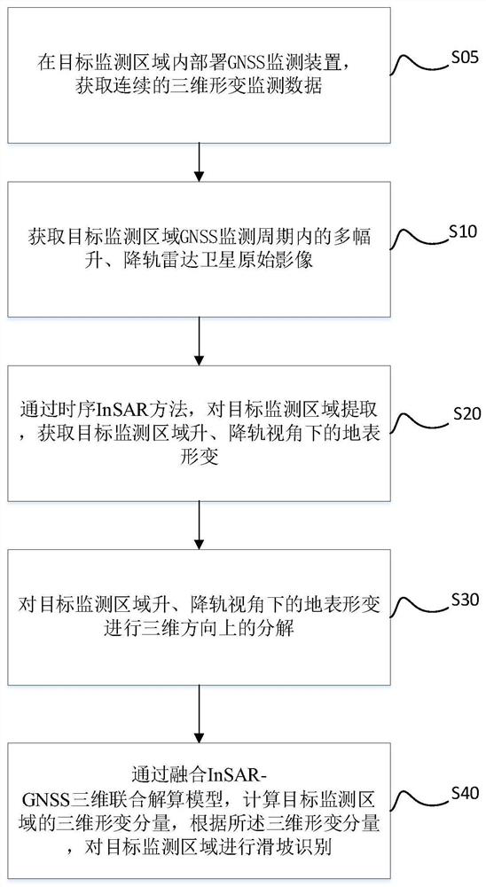
[0076] As a possible implementation, it also includes a GNSS monitoring device:

[0077] Deployed in the target monitoring area, it is used to obtain continuous three-dimensional deformation monitoring data during the monitoring cycle of the target detection area.

[0078] The obtained continuous three-dimensional deformation monitoring data within the detection period of the target detection area provides data support for the combination of the ascending and descending orbit data and GNSS monitoring data, and ensures the effective implementation of the landslide identification method for the target monitoring area.

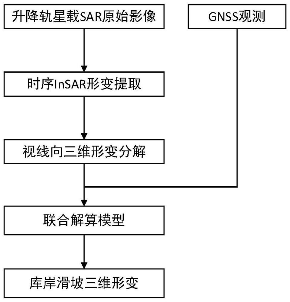
[0079] As a possible implementation, the three-dimensional joint solution model device is also used to determine the relationship between the deformation rate of the interferogram of the lifting rail InSAR and the deformation rate in the three-dimensional orthogonal direction according to the geometric principle of SAR image imaging;

[0080] Building a three-dim...


PUM


Abstract

The invention discloses a landslide three-dimensional deformation calculation method fusing GNSS and ascending and descending orbit time sequence InSAR, which belongs to the technical field of risk identification, and is used for solving the technical problem of incomplete results of an existing detection mode. The method comprises the following steps of: acquiring a plurality of ascending and descending orbit radar satellite original images in a GNSS monitoring period of a target monitoring area; acquiring surface deformation of the target monitoring area under the view angle of a ascending and descending orbit radar through a time sequence InSAR method; decomposing the surface deformation of the target monitoring area in the three-dimensional direction under the view angle of the ascending and descending orbit radar; and calculating three-dimensional deformation of the target monitoring area by fusing an InSAR-GNSS three-dimensional joint calculation model, and performing landslide identification on the target monitoring area according to the three-dimensional deformation. According to the method, the problem that it is difficult for InSAR to obtain three-dimensional deformationis effectively solved, effective unification of high time resolution and high plane position precision of GNSS and high spatial resolution and elevation deformation precision of the InSAR technology is realized, and the method has very high practicability for obtaining a landslide three-dimensional deformation field.

Description

technical field [0001] The invention relates to the technical field of risk identification, in particular to a landslide three-dimensional deformation calculation method and system that integrates GNSS and ascending and descending rail timing InSAR. Background technique [0002] Accurate and effective monitoring of landslides is the basis for early prediction of landslide disasters, and is also an important means of landslide disaster risk assessment and disaster prevention and mitigation. The traditional slope contact safety monitoring method has high cost, difficult equipment maintenance, low reliability, and can only obtain "point" monitoring information, and it is difficult to obtain slope "surface" dynamic change information, which is not suitable for reservoir slopes Large-scale deformation monitoring. Synthetic aperture radar interferometry (Interferometric Synthetic Aperture Radar, InSAR) technology can carry out stable and continuous observation of the surface with...

Claims


Application Information

Patent Timeline
Patent Type & Authority Applications(China)
IPC IPC(8): G01S13/90G01S13/86G01S19/14
CPCG01S13/9021G01S13/9023G01S13/885G01S13/86G01S19/14
Inventor 周伟马洪琪肖海斌程翔陈鸿杰周志伟迟福东马刚潘斌
Owner WUHAN UNIV
Why Eureka
Try Eureka