Rainfall estimation method and system coupled with dry and wet state identification and multi-source information fusion

A multi-source information fusion and status technology, applied in resources, computing, computer-aided design, etc., can solve problems such as mutual interference of different information, lack of identification, range of rainy and non-rainy areas and spatial location deviations in estimated results, etc., to achieve Strong scalability and the effect of reducing quantitative estimation errors

Active Publication Date: 2021-05-14
NANJING HYDRAULIC RES INST +1
View PDF18 Cites 6 Cited by
  • Summary
  • Abstract
  • Description
  • Claims
  • Application Information

AI Technical Summary

Problems solved by technology

These algorithms usually directly estimate the magnitude of grid precipitation. When applied to short-duration precipitation (such as day, hour, etc.) Different information interferes with each other in the process of integrating multipl

Method used


Image

  • Rainfall estimation method and system coupled with dry and wet state identification and multi-source information fusion
  • Rainfall estimation method and system coupled with dry and wet state identification and multi-source information fusion
  • Rainfall estimation method and system coupled with dry and wet state identification and multi-source information fusion

Examples


Embodiment 1

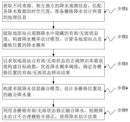
[0061] A method for estimating precipitation coupled with wet and dry state identification and multi-source information fusion, comprising the following steps:

[0062] Obtain different sources and independent multi-source precipitation observation information; extract the rain / no rain status value of the ground station based on the precipitation observed at the ground station, and use the geographic weighted regression model GWR to estimate the precipitation probability of the ground station and each grid; optimize the precipitation probability Threshold to identify the rain / no-rain status of the ground station and each grid; use the GWR method to fuse geographic and multi-source precipitation information to obtain grid fusion precipitation; use the grid rain / no-rain status identification results to correct the fusion precipitation , to get the precipitation estimation result.

Embodiment 2

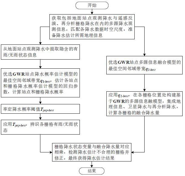
[0064] On the basis of Embodiment 1, Embodiment 2 further proposes the refinement steps of the precipitation estimation method coupled with wet and dry state identification and multi-source information fusion, as follows:

[0065] Step 1. Data preprocessing: Obtain grid precipitation data from different sources and independent ground stations (weather stations, rainfall stations, etc.) in the study area to observe precipitation, remote sensing inversion, reanalysis, etc.; match the time of various grid precipitation data and spatial resolution; match the spatial scale of grid and site precipitation; prepare geographic information such as latitude and longitude, elevation, and slope of site and grid;

[0066] Step 11: Obtain multi-source precipitation observation information that is independent of each other from different sources;

[0067] Step 12: Determine the temporal and spatial resolution of the grid precipitation estimation; in terms of time, accumulate or decompose the ...

Embodiment 3

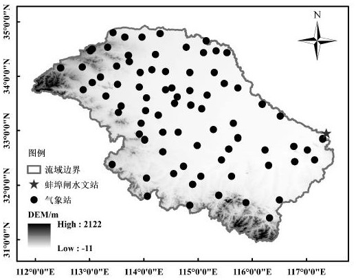
[0096] In this example, the catchment area above the Bengbu Gate hydrological station in the Huaihe River Basin is taken as the research area, and a precipitation estimation method coupled with wet and dry state identification and multi-source information fusion is proposed. The Huaihe River Basin is between the Yangtze River and the Yellow River, with an area of ​​about 270,000 km 2 . The Bengbu Gate Hydrological Station is the main control station in the middle reaches of the Huaihe River. The longitude and latitude range of the catchment area controlled is 111.9°~117.5°E, 30.9°~34.9°N, with an area of ​​about 117,000 km 2 . Butongbai Mountain and Funiu Mountain are in the northwest of the basin, Dabie Mountain is in the southwest, and the rest is a vast plain. The hilly area only accounts for 15.4% of the basin. The annual average precipitation is about 920 mm, which generally decreases from south to north, and the precipitation in the flood season (June-September) accoun...


PUM


Abstract

The invention discloses a rainfall estimation method and system coupled with dry and wet state identification and multi-source information fusion. The method comprises the following steps: obtaining various mutually independent rainfall observation information from different sources including ground station observation, remote sensing inversion and reanalysis; based on ground observation rainfall, extracting station rain/no rain state values, selecting a geographically weighted regression model, and estimating the rainfall probability of each station and a grid; preferably selecting a rainfall probability threshold value, and identifying a rain/no-rain state of each grid; fusing geography and multi-source precipitation information by adopting a geography weighted regression method to obtain grid fusion precipitation; and correcting and fusing the precipitation amount by using the rain/no-rain state identification result of each grid, and obtaining a precipitation amount estimation result. According to the method, modeling and coupling are carried out on the rainfall dry and wet state and the rainfall amount respectively, the accuracy of rain area and rain-free area identification is effectively improved, the obtained rainfall space distribution is more consistent with the reality, the false alarm rate and the false alarm error are greatly reduced, and other precision indexes are also improved.

Description

technical field [0001] The invention relates to the technical field of precipitation quantitative estimation, in particular to a precipitation estimation method and system coupled with wet and dry state identification and multi-source information fusion. Background technique [0002] Affected by multiple factors such as terrain, climate, and human activities, precipitation presents complex spatiotemporal variability, making it the most difficult meteorological variable to accurately estimate. At present, precipitation estimation methods are continuously enriched, mainly including ground observation stations, meteorological satellites and weather radar remote sensing inversion, numerical model reanalysis and forecasting, etc. Ground observation stations can obtain point-like high-precision precipitation information, but the discrete distribution and insufficient spatial representation of the stations cannot reflect the continuous spatial structure of precipitation; while remo...

Claims


Application Information

Patent Timeline
IPC IPC(8): G06F30/20G06Q10/04G06Q10/06G06Q50/26G06F111/08G06F113/08G06F119/12
CPCG06Q10/04G06Q10/06393G06Q50/26G06F30/20G06F2111/08G06F2113/08G06F2119/12Y02A90/10
Inventor 李伶杰王磊之胡庆芳王银堂云兆得邓鹏鑫刘勇崔婷婷
Owner NANJING HYDRAULIC RES INST
Why Eureka
Try Eureka