Support-free low-orbit navigation enhancement system and method based on satellite-based enhancement service

A technology for enhancing services and enhancing systems, which is applied in the field of satellite navigation and can solve the problems of ground control centers, excessive dependence on satellite uplink and downlink and inter-satellite links, and poor real-time performance of low-orbit navigation enhancement systems.

Pending Publication Date: 2021-05-18
XIAN INSTITUE OF SPACE RADIO TECH
View PDF0 Cites 4 Cited by
  • Summary
  • Abstract
  • Description
  • Claims
  • Application Information

AI Technical Summary

Problems solved by technology

[0006] The technical problem to be solved by the present invention is: to overcome the deficiencies of the prior art, the present invention builds a non-reliant low-orbit navigation augmentation system and method with autonomous operation capabilities and autonomous navigation and positioning service capabilities based on satellite-based augmentation services, which solves the problem of The existing low-orbit navigation augmentation system relies too much on the ground control center, satellite uplink and downlink, and inter-satellite link. At the same time, the system and method designed by the present invention do not involve satellite uplink and downlink and inter-satellite link data transmission. It can further solve the problem of poor real-time performance of the existing low-orbit navigation augmentation system

Method used


Image

  • Support-free low-orbit navigation enhancement system and method based on satellite-based enhancement service
  • Support-free low-orbit navigation enhancement system and method based on satellite-based enhancement service
  • Support-free low-orbit navigation enhancement system and method based on satellite-based enhancement service

Examples


Embodiment 1

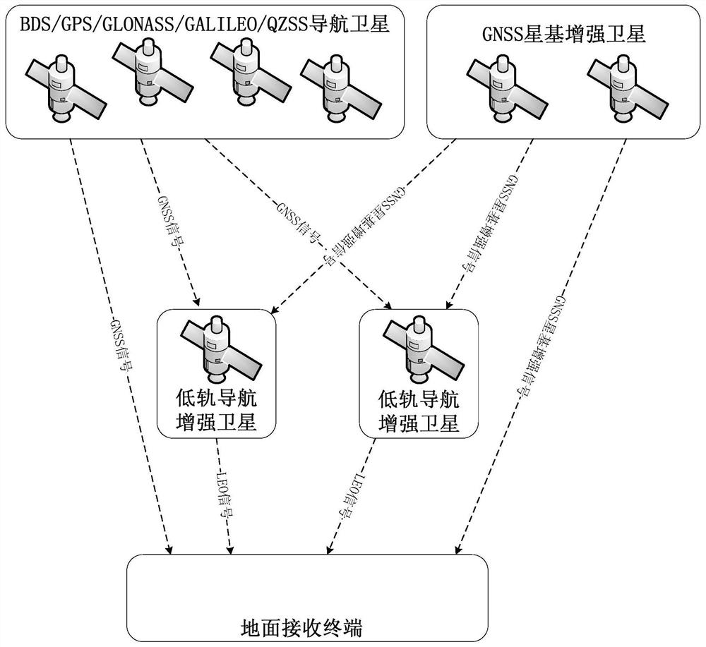
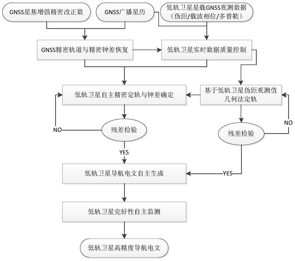
[0133] The overall design framework of the unsupported low-orbit navigation augmentation system based on satellite-based augmentation service of the present invention is as follows: figure 1 As shown, it mainly includes four parts: GNSS navigation satellites, GNSS satellite-based augmentation satellites, low-orbit navigation augmentation satellites, and ground receiving terminals.

[0134] GNSS navigation satellite

[0135] GNSS navigation satellites generate ranging codes and carriers under the control of satellite-borne atomic clocks, modulate ranging codes and navigation messages on the carriers, and continuously broadcast them to low-orbit satellites and ground users to provide positioning, speed measurement and timing services. The GNSS navigation satellites in the present invention should at least include one or more of the Chinese Beidou system, the American GPS system, the Russian GLONASS system, and the EU GALILEO system that have provided official services.

[0136]...


PUM


Abstract

The invention relates to a support-free low-orbit navigation enhancement system and method based on a satellite-based enhancement service. The support-free low-orbit navigation enhancement system comprises a GNSS navigation satellite, a GNSS satellite-based enhancement satellite, a low-orbit navigation enhancement satellite and a ground receiving terminal, according to the invention, a support-free low-orbit navigation enhancement system with autonomous operation capability and autonomous navigation positioning service capability is constructed based on the satellite-based enhancement service, so that the problem that the existing low-orbit navigation enhancement system excessively depends on a ground control center, satellite uplink and downlink links and inter-satellite links is solved; meanwhile, the system and the method designed by the invention do not involve satellite uplink and downlink and inter-satellite link data transmission, and can further solve the problem of poor real-time performance of the existing low-orbit navigation enhancement system.

Description

technical field [0001] The invention belongs to the field of satellite navigation, and in particular relates to a supportless low-orbit navigation enhancement system and method. Background technique [0002] The American Global Positioning System (GPS), developed in the 1990s, has completely changed the way of modern warfare, and has also profoundly influenced and changed the production and life of human society. In the second decade of the 21st century, with the modernization of Russia's GLONASS, the opening and operation of China's Beidou-3 BDS-3 system, and the European Union's Galileo GALILEO system entering the FOC stage of full-featured operation, the current four global satellite navigation and positioning systems GNSS It has been able to provide meter-level navigation and positioning services for global users in open scenarios. However, in some fields, such as geodetic surveying, marine exploration, deformation monitoring, etc., they all put forward real-time centim...

Claims


Application Information

Patent Timeline
IPC IPC(8): G01S19/44G01S19/25
CPCG01S19/44G01S19/256
Inventor 蒙艳松边朗周泉王瑛严涛田野李天
Owner XIAN INSTITUE OF SPACE RADIO TECH
Why Eureka
Try Eureka