Railway route selection terrain analysis chart making method and system based on high-resolution remote sensing

A technology of terrain analysis and production method, which is applied in the direction of radio wave measurement system, satellite radio beacon positioning system, measurement device, etc., can solve the problems of low technological content, long mapping cycle, large production investment, etc., and achieve accurate drawing , Short period of drawing, reducing the effect of investment

Pending Publication Date: 2021-05-28
CHINA RAILWAY FIFTH SURVEY & DESIGN INST GRP
View PDF3 Cites 0 Cited by
  • Summary
  • Abstract
  • Description
  • Claims
  • Application Information

AI Technical Summary

Problems solved by technology

[0004] Aiming at the defects of the prior art, the purpose of the present invention is to provide a method and system for making a topographic analysis map for railway line selection based on high-resolution remote sensing, aiming to solve the problem of large investment and long period of time for making topographic analysis maps for line selection in existing railway projects. long, and the problem of low technological content

Method used


Image

  • Railway route selection terrain analysis chart making method and system based on high-resolution remote sensing

Examples


Embodiment Construction

[0029] In order to make the objectives, technical solutions and advantages of the present invention clearer, the present invention will be further described in detail below with reference to the accompanying drawings and embodiments. It should be understood that the specific embodiments described herein are only used to explain the present invention, but not to limit the present invention.

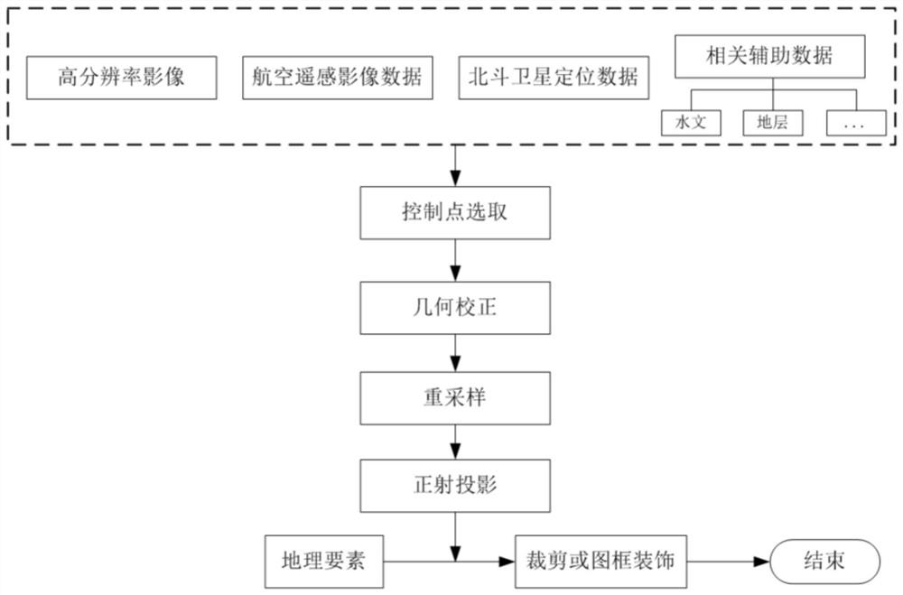
[0030] The purpose of the present invention is to provide a method for making a topographic analysis map of railway line selection based on high-resolution remote sensing in view of the above-mentioned defects of large investment, long drawing cycle, and low scientific and technological content in the production of the existing railway project line selection topography analysis map, and Integrate Beidou navigation and positioning technology.

[0031] The invention relates to the field of railway terrain surveying and mapping, in particular to a method for making a high-precision terrain an...


PUM


Abstract

The invention relates to the field of railway topographic surveying and mapping, and especially relates to a railway route selection terrain analysis chart making method and system based on high-resolution remote sensing. First, image control points are reasonably arranged, control points are as uniform as possible, and accurate joint measurement of the image control points is performed by using a Beidou satellite system. Then, high-resolution remote sensing data, Beidou position data and the like are used for rapidly and accurately obtaining topographic relief and other conditions, a reasonable ortho-rectification optimization algorithm and an optimal image resampling method are selected for three-dimensional display, ortho-rectification is carried out on the high-resolution remote sensing image, and an ortho-image is generated. Then superposition of related geographic elements is performed, and clipping and picture frame finishing are carried out according to standard framing of a required topographic map scale. And superposition registration is performed on the framed remote sensing image and the existing digital linearized map, and a corresponding map updating, plotting and supplementary calculation method is designed so as to carry out final high-precision topographic map production.

Description

technical field [0001] The invention belongs to the field of railway terrain surveying and mapping, and more particularly relates to a method and system for making a terrain analysis map for railway line selection based on high-resolution remote sensing. Background technique [0002] The traditional aerial photogrammetry railway engineering line selection topographic map production method has few defects in the application of high-resolution remote sensing technology, large investment, and long mapping cycle. The use of high-resolution remote sensing images and Beidou satellite positioning technology to produce high-precision topographic maps can reduce the investment in topographic analysis and mapping in railway line selection and shorten the mapping time. To a certain extent, it can meet the needs of auxiliary support for the pre-engineering of railway construction. [0003] In view of the needs of auxiliary support for railway construction in the early stage, it is urge...

Claims


Application Information

Patent Timeline
Patent Type & Authority Applications(China)
IPC IPC(8): G01C11/02G01S19/42
CPCG01C11/02G01S19/42
Inventor 吴永胜殷骏时洪斌汤友富桂婞唐抗尼李云帆饶雄李佳茜
Owner CHINA RAILWAY FIFTH SURVEY & DESIGN INST GRP
Why Eureka
Try Eureka