Deep-sea landform joint matching aided navigation and positioning system and deep-sea landform joint matching aided navigation and positioning method

A technology of terrain and geomorphology and auxiliary navigation, which is applied in navigation, surveying and mapping and navigation, navigation calculation tools, etc., can solve the problems of poor correlation, mutual interference, and singleness of underwater terrain matching and underwater topography matching, and achieve deep-sea accurate matching Navigation and positioning, the effect of improving accuracy

Pending Publication Date: 2021-06-04
NAT DEEP SEA CENT
View PDF15 Cites 0 Cited by
  • Summary
  • Abstract
  • Description
  • Claims
  • Application Information

AI Technical Summary

Problems solved by technology

However, due to the space, energy consumption, cost, etc. of the deep-sea vehicle, as well as the mutual interference of the multi-beam sounding system and the side-scan sonar emission signals, the deep-sea vehicle usually does not carry the multi-beam sounding system and the side-scan sonar at the same time. accept
This leads to poor correlation between underwater terrain matching and underwater terrain matching, and often only a single underwater terrain matching assisted navigation or underwater terrain matching assisted navigation is performed, and underwater terrain matching assisted navigation is performed with a multi-beam bathymetry system mainly
However, underwater terrain matching aided navigation is not suitable for areas that are flat or where the terrain fluctuations are not obvious

Method used


Image

  • Deep-sea landform joint matching aided navigation and positioning system and deep-sea landform joint matching aided navigation and positioning method
  • Deep-sea landform joint matching aided navigation and positioning system and deep-sea landform joint matching aided navigation and positioning method

Examples


Embodiment 1

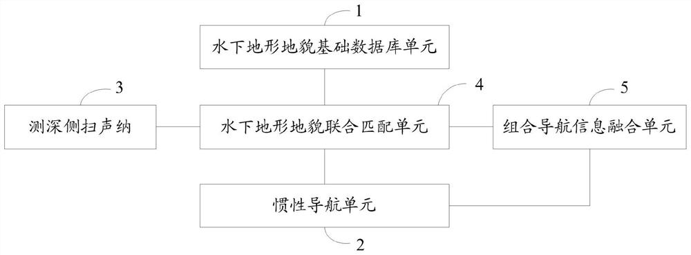
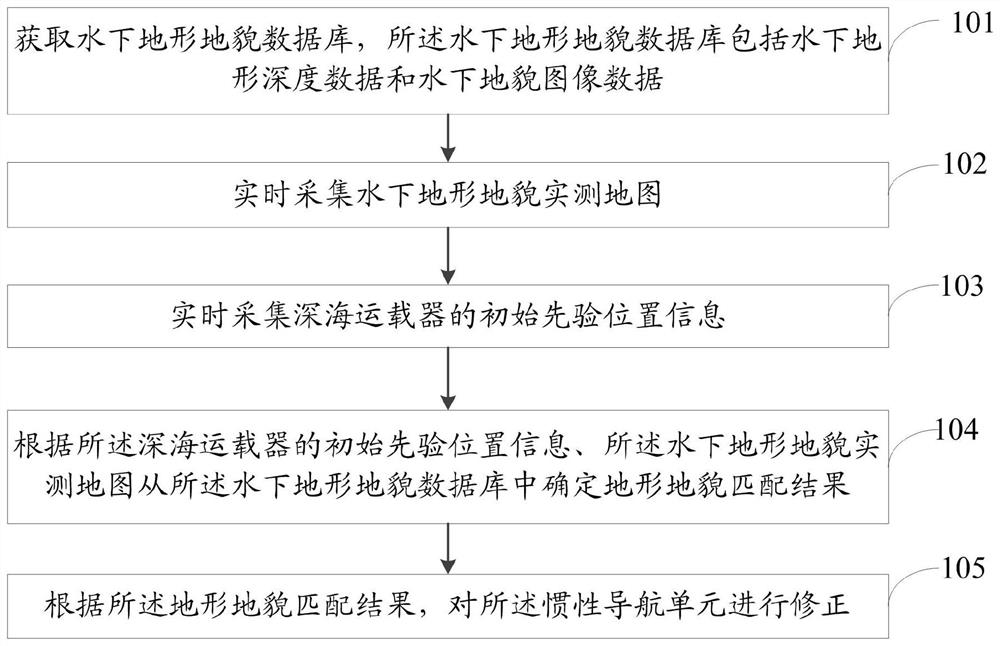
[0046] This embodiment provides a specific deep-sea topography joint matching assisted navigation and positioning method, the method includes:

[0047] (1) According to the planned tasks and scheduled routes of the deep-sea vehicle, select the basic database of underwater topography and geomorphology within a certain range near the predetermined route from the existing basic database of underwater topography and geomorphology, perform grid processing, and store it in the deep-sea vehicle , as a reference map of underwater topography.

[0048] (2) Under the guidance of the inertial navigation unit, the deep-sea vehicle sails along the predetermined route.

[0049] (3) During the voyage, turn on the bathymetric side-scan sonar to simultaneously measure the seabed topography and landform data under the deep-sea vehicle, and perform preprocessing and storage.

[0050] (4) Select the topographic and geomorphic data at the current moment and a certain time before or within the rang...


PUM


Abstract

The invention relates to a deep-sea landform joint matching aided navigation and positioning system and a deep-sea landform joint matching aided navigation and positioning method. The system comprises an underwater topography and landform basic database unit, an inertial navigation unit, a sounding side-scan sonar, an underwater topography and landform joint matching unit and a combined navigation information fusion unit which are arranged in a deep sea vehicle; the underwater topography and landform joint matching unit is connected with the underwater topography and landform basic database unit, the inertial navigation unit, the sounding side-scan sonar and the combined navigation information fusion unit, and the combined navigation information fusion unit is connected with the inertial navigation unit. According to the invention, the accuracy of underwater navigation and positioning can be improved, and deep-sea accurate matching navigation and positioning can be realized.

Description

technical field [0001] The invention relates to the field of deep-sea navigation and positioning, in particular to a deep-sea topography and landform joint matching auxiliary navigation and positioning system and method. Background technique [0002] The accuracy and reliability of the underwater navigation and positioning system are directly related to whether the deep-sea vehicle can successfully complete the scheduled mission and return safely. Underwater navigation and positioning are mainly divided into three categories: underwater acoustic navigation, inertial / dead reckoning navigation, and geophysical navigation. Within the range of action of the acoustic array, long baselines and ultra-short baselines can achieve reliable underwater positioning, but the cost of use is high and the navigation range is limited. . Inertial / dead reckoning navigation does not require external support. The data required for navigation and reckoning are all obtained by the sensors carried...

Claims


Application Information

Patent Timeline
Patent Type & Authority Applications(China)
IPC IPC(8): G01C21/16G01C21/18G01C7/00G01C21/20
CPCG01C7/00G01C21/165G01C21/18G01C21/20
Inventor 张同伟闫磊王向鑫杨磊秦升杰李正光
Owner NAT DEEP SEA CENT
Why Eureka
Try Eureka