
Multi-thread system for constructing orthoimage semantic map in real time

An orthophoto and semantic map technology, which is applied in the system field of multi-threaded real-time construction of orthophoto semantic maps, can solve the problem that the requirements of real-time/accuracy and robustness cannot be met, and the changes of target elements cannot be effectively reflected in real time. , the weakening of comprehensive survey capabilities of operations, etc., to avoid the iterative update of network weights, avoid excess and waste of hardware resource performance, and achieve the effect of high real-time and timeliness

Pending Publication Date: 2021-06-18
中国兵器装备集团自动化研究所有限公司
View PDF0 Cites 4 Cited by
  • Summary
  • Abstract
  • Description
  • Claims
  • Application Information

AI Technical Summary

Problems solved by technology

[0004] The existing methods of detection cannot effectively reflect the changes of the target elements in the target area in real time, and there are problems such as poor timeliness and incomplete information. The comprehensive operation reconnaissance capability is seriously weakened, and it cannot meet the requirements of real-time / accuracy and recklessness of current military operations. Rod requirements

Method used


Image

  • Multi-thread system for constructing orthoimage semantic map in real time
  • Multi-thread system for constructing orthoimage semantic map in real time
  • Multi-thread system for constructing orthoimage semantic map in real time

Examples


Embodiment

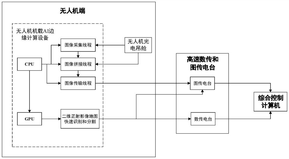
[0048]A system for constructing semantic maps of orthophotos in real time with multiple threads, such as figure 1 As shown, including drone photoelectric pods, AI edge computing equipment, radio stations and integrated control computers;

[0049] UAV photoelectric pod, used to collect aerial images of ground terrain;

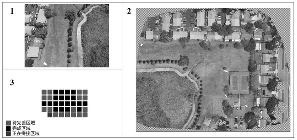
[0050] AI edge computing equipment, mounted on the drone pod platform, is used to construct a two-dimensional orthophoto map based on aerial images; it is also used to identify and segment environmental elements in the two-dimensional orthophoto map;

[0051] A radio station for transmitting the two-dimensional orthophoto map and the segmentation results of environmental elements to the integrated control computer;

[0052] Wherein, the segmentation result is position data of each segmented area;

[0053] The comprehensive control computer is used to color-code the two-dimensional orthophoto map according to the segmentation results to form a semantic map of t...


PUM


Abstract

The invention discloses a system for multithreading real-time construction of an orthoimage semantic map. The system comprises an unmanned aerial vehicle photoelectric pod, an AI edge computing device, a radio station and a comprehensive control computer. The unmanned aerial vehicle photoelectric pod is used for collecting aerial images of the ground terrain; the AI edge computing device is used for constructing a two-dimensional orthoimage map according to the aerial image and identifying and segmenting environmental elements; the radio station is used for transmitting the segmentation results of the two-dimensional orthoimage map and the environmental elements to the comprehensive control computer; and the comprehensive control computer is used for carrying out color separation marking on the two-dimensional orthoimage map according to the segmentation result to form a two-dimensional orthoimage semantic map. According to the multi-thread system for constructing the orthoimage semantic map in real time, the AI edge computing device is constructed on the unmanned aerial vehicle, and construction of the two-dimensional orthoimage map is transferred to the AI edge computing device from the ground workstation, so that the real-time performance and timeliness of image splicing are higher.

Description

technical field [0001] The invention relates to the technical field of individual soldier reconnaissance, in particular to a system for constructing an orthophoto semantic map in real time with multiple threads. Background technique [0002] In recent years, with the in-depth exploration of the UAV aerial survey field, UAV oblique photography technology has developed rapidly. Using the platform based on UAV oblique photography, you can quickly obtain a large number of video image geographic details of the target area, and then transmit the video and image information to the ground workstation through high-speed image transmission technology, and process the acquired map information to Help practitioners understand the actual situation of the aerial survey area more comprehensively and intuitively. Due to its low cost, high efficiency, flexible maneuverability, and simple deployment, the real-time map mosaic generation technology based on UAV aerial images is widely used in ...

Claims


Application Information

Patent Timeline
Patent Type & Authority Applications(China)
IPC IPC(8): G06T11/20G06T7/11G06T3/40G06T7/33G06T1/20G06T1/60G06K9/62G06K9/00G06N3/04G06F9/50
CPCG06T11/206G06T7/11G06T3/4038G06T7/33G06T1/20G06T1/60G06N3/04G06F9/5072G06F2209/502G06V20/13G06F18/253
Inventor 刘议聪隋旭阳赖春强张振禹马婷霞李亚南陈大鹏王钤刘歆浏
Owner 中国兵器装备集团自动化研究所有限公司
Learn More