
Air-ground collaborative search and rescue system and method

A technology of search and rescue and air-ground coordination, applied in the field of air-ground collaborative search and rescue systems, can solve the problems of lack of search and rescue, lack of information review links, and difficulty in obtaining clarity of data, etc., and achieve the effect of fast search and positioning

Inactive Publication Date: 2021-06-25
HUNAN NOVASKY ELECTRONICS TECH
View PDF6 Cites 1 Cited by
  • Summary
  • Abstract
  • Description
  • Claims
  • Application Information

AI Technical Summary

Problems solved by technology

At present, these devices are mainly operated manually by personnel, and the equipment on unmanned platforms is relatively small. UAV-borne life detection radars have been sold, but the market stock is relatively small and is still in the expansion stage.
[0005] 3) In terms of rescue teams, there are relatively few professional rescue teams, relatively weak search and rescue equipment and technical means, lack of systematic communication equipment construction, and lack of effective means, tools and platforms for on-site command and control; search and rescue efficiency and quality are not high
[0006] 4) Complex disaster search and rescue sites still face challenges such as difficulty in grasping the situation and difficulty in task coordination. It is necessary to develop an emergency command platform for multi-task coordination and optimization
[0007] In the search and rescue field of complex disasters such as earthquakes, landslides, landslides, floods, forest fires, etc., there are relatively single detection and search methods, low life search and rescue efficiency, poor on-site information acquisition and sharing, weak resource scheduling effectiveness, and lack of search and rescue systems. and other issues, specifically:
[0008] 1) In terms of disaster data acquisition and judgment, based on satellite remote sensing and telemetry technology, radar and optical sensors mounted on satellite platforms are used to obtain ground disaster conditions. Since the general operating altitude is 150-1500 kilometers from the ground, the resolution of ground targets Compared with low-altitude drone platforms (100-500 meters), it is poor, and at the same time, it is vulnerable to cloud cover and weather conditions, which makes it difficult to obtain data, or the clarity is not high, and the reliability is poor;
[0009] 2) In terms of searching and locating trapped persons, manual search is the main method on the ground. Rescuers carry search equipment into the disaster area, and there are few or no handling equipment available. Generally, the detection equipment is moved point by point to traverse the target area by manual movement. Scanning and detection, the search efficiency is low, and the structural stability in the disaster area is poor. When manually moving the equipment, it is easy to trigger secondary disasters or the rescue team is in a dangerous situation;
[0010] 3) Rescue teams arrive at the disaster area at different times and in different locations, lack of unified means of communication and communication, and when a disaster occurs, the general on-site communication network, power network, etc. will be interrupted, and the rescue teams lack effective communication and exchanges. The acquired data / information cannot be shared and updated in real time;
[0011] 4) Rescue teams are isolated from each other, and the search and rescue resources they carry cannot be shared, resulting in uneven distribution of rescue site data and forces, and weak ability to rationally dispatch
Its shortcomings are: using a single UAV to judge the location of the person in distress through a directional antenna, on the one hand, the accuracy is too low, and on the other hand, the directional antenna will reduce the search area; at the same time, it is impossible to distinguish the person in distress by simply using the wireless signal strength to judge the information of the person in distress. Whether the source of the signal is sent by the person in distress or the search and rescue personnel, that is, the probability of misjudgment is high; in addition, the search and rescue range of a single drone is small, and it is not suitable for large-scale search and rescue activities
Its shortcomings are: on the one hand, it is affected by the layout and height of the UAV, and the positioning accuracy is low; The signal sent by the mobile terminal of the person in distress may cause the failure of the search and positioning; in addition, this scheme lacks information review links, and is not suitable for searching for hidden targets, and its practicability is weak

Method used


Image

  • Air-ground collaborative search and rescue system and method
  • Air-ground collaborative search and rescue system and method
  • Air-ground collaborative search and rescue system and method

Examples


Embodiment Construction

[0046] The present invention will be further described below in conjunction with the accompanying drawings and specific embodiments.

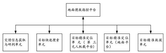
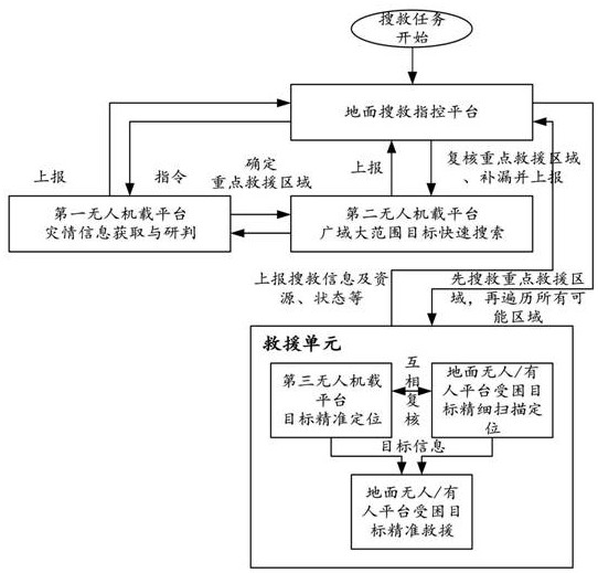
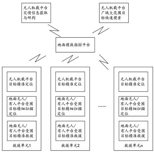
[0047] Such as figure 1 As shown, the air-ground collaborative search and rescue system of this embodiment can be applied to the rapid rescue of large-scale disaster sites such as earthquakes, landslides, landslides, debris flows, forest fires, etc., specifically including disaster information acquisition and judgment units, target rapid search units, and accurate target The positioning unit, the precise target rescue unit and the ground search and rescue command platform, the disaster information acquisition and judgment unit, the target fast search unit, the target precise positioning unit and the target precise rescue unit are all connected to the ground search and rescue command platform;

[0048] The disaster information acquisition and research unit is connected with the target rapid search unit, and is used to obtain the disaster data of...


PUM


Abstract

The invention discloses an air-ground collaborative search and rescue system and method, and the system comprises: a disaster information obtaining, studying and judging unit which is used for obtaining disaster data of a disaster area through a first unmanned plane platform, and determining a key rescue area; the target rapid search unit that is used for carrying out wide-area and large-range target rapid search on the disaster area through the second unmanned aerial vehicle platform, re-checking the key rescue area and searching for other missing key rescue areas; the ground search and rescue command and control platform that is used for receiving all final key rescue area information, forming a rescue scheme and issuing a search and rescue instruction; the target accurate positioning unit that is used for receiving the search and rescue instruction, searching and positioning trapped targets in a key rescue area through a third unmanned aerial vehicle platform or / and a ground platform, and obtaining trapped target information; and the target accurate rescue unit that is used for receiving the trapped target information and rescuing the trapped target. The invention has the advantages of rapidness, accuracy, high efficiency, systematization, process, standardization and the like in search and rescue.

Description

technical field [0001] The present invention mainly relates to the technical field of disaster rescue, in particular to an air-ground collaborative search and rescue system and method. Background technique [0002] With the rapid expansion of urban buildings, once large-scale disasters such as earthquakes, landslides, and fires occur, the casualties will be huge. In the face of large-scale disasters, the rapid search and rescue of survivors requires large-scale accurate search and positioning and efficient dispatch of on-site resources. Currently relevant search and rescue methods include the following: [0003] 1) UAV remote sensing technology has unique technical advantages in quickly and flexibly acquiring high-resolution images. It generally flies smoothly at low altitudes, making up for satellite optical remote sensing and ordinary aerial photography that are often blocked by clouds and affected by meteorological conditions. The flaws of the image are not limited by t...

Claims


Application Information

Patent Timeline
IPC IPC(8): G06K9/00G06Q50/26
CPCG06Q50/26G06V20/13G06V20/41
Inventor 王生水韩明华唐良勇贺玉贵
Owner HUNAN NOVASKY ELECTRONICS TECH
Learn More