
Remote sensing image semantic segmentation method and device, computer equipment and storage medium

A remote sensing image and semantic segmentation technology, applied in the field of aerospace remote sensing, can solve the problems of poor segmentation effect of small objects and edges, limited discrimination ability, affecting the accuracy of feature fusion, etc., so as to improve the efficiency of feature fusion, improve the accuracy, and eliminate the semantic gap. Effect

Active Publication Date: 2021-06-25
HUNAN UNIV
View PDF6 Cites 5 Cited by
  • Summary
  • Abstract
  • Description
  • Claims
  • Application Information

AI Technical Summary

Problems solved by technology

Although these methods can effectively improve the segmentation results, there are still some limitations in the semantic segmentation of remote sensing images: 1) The high-frequency texture information contained in the deep semantic features is less, and more is lost after passing through the global context aggregation module. High-frequency information, so the segmentation effect on small objects and edges is poor
2) The global context aggregation module has limited discriminative ability in large-scale remote sensing images, so there will be spatial fragmentation predictions in the final segmentation results due to lack of context information
However, due to the influence of a series of convolution and pooling between different feature layers in the feature extraction layer, there will be a phenomenon that the features are difficult to align, which will affect the accuracy of feature fusion.

Method used


Image

  • Remote sensing image semantic segmentation method and device, computer equipment and storage medium
  • Remote sensing image semantic segmentation method and device, computer equipment and storage medium
  • Remote sensing image semantic segmentation method and device, computer equipment and storage medium

Examples


Embodiment Construction

[0051] In order to enable those skilled in the art to better understand the technical solutions of the present invention, the present invention will be further described in detail below in conjunction with the accompanying drawings.

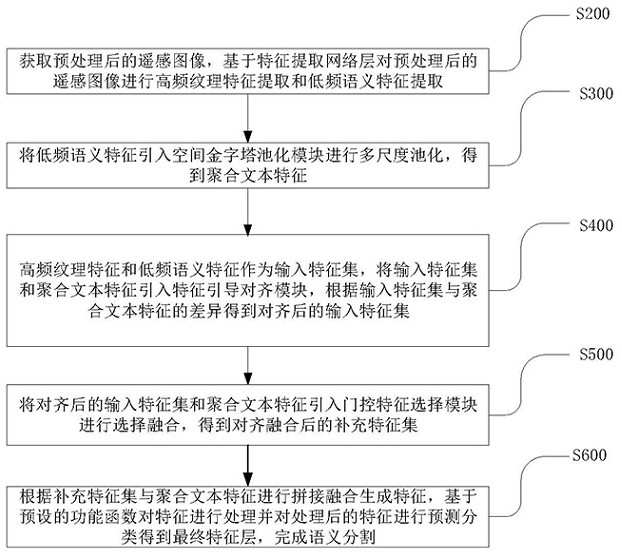
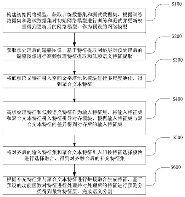
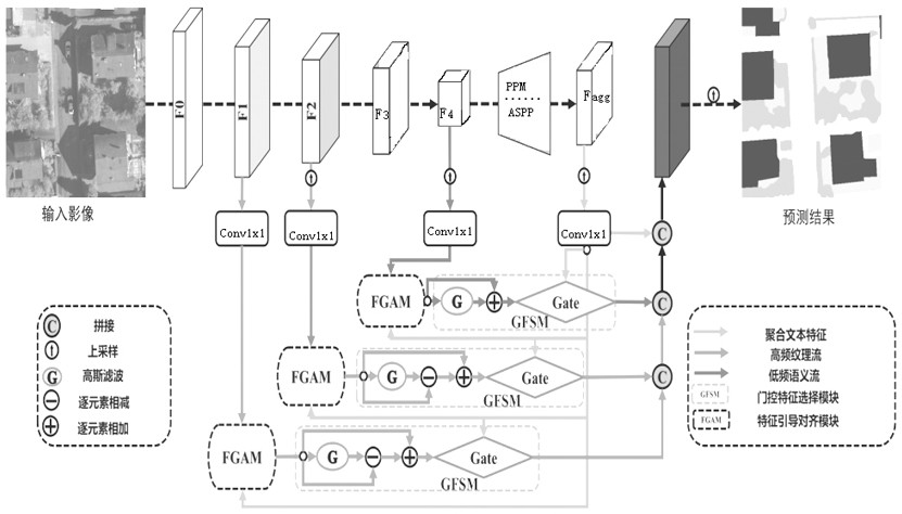
[0052] In one embodiment, such as figure 1 , 2 As shown, a remote sensing image semantic segmentation method is implemented based on a preset network model. The preset network model includes a feature extraction network layer, a spatial pyramid pooling module, a feature-guided alignment module, and a gating feature selection module. The method includes the following step:

[0053] Step S200: Acquire the preprocessed remote sensing image, and perform high frequency texture feature extraction and low frequency semantic feature extraction on the preprocessed remote sensing image based on the feature extraction network layer;

[0054] Step S300: introducing low-frequency semantic features into the spatial pyramid pooling module for multi-scale pool...


PUM


Abstract

The invention discloses a remote sensing image semantic segmentation method and device, computer equipment and a storage medium, and the method comprises the steps of obtaining a preprocessed remote sensing image, carrying out the high-frequency texture feature and low-frequency semantic feature extraction of the preprocessed remote sensing image based on a feature extraction network layer, and taking the extracted features as an input feature set; introducing the low-frequency semantic features into a spatial pyramid pooling module for multi-scale pooling, and obtaining aggregated text features; introducing the input feature set and the aggregated text features into a feature guide alignment module, and obtaining an aligned input feature set according to the difference between the input feature set and the aggregated text features; introducing the aligned input feature set and the aggregated text features into a gating feature selection module for selective fusion to obtain an aligned and fused supplementary feature set; and according to the supplementary feature set and the aggregated text features, performing splicing fusion to generate features, processing the features based on a preset performance function, and performing prediction classification on the processed features to obtain a final feature layer. The segmentation precision is effectively improved.

Description

technical field [0001] The invention relates to the technical field of aerospace remote sensing, in particular to a remote sensing image semantic segmentation method, device, computer equipment and storage medium. Background technique [0002] Semantic segmentation refers to classifying each pixel in an image and marking pixels belonging to the same category as the same token. Semantic segmentation, as a core research field in computer vision, is the basis of image interpretation. With the rapid development of deep learning in recent years, semantic segmentation also has a huge application background in high-resolution remote sensing images, such as: land use mapping, urban planning, agricultural insurance, etc. [0003] The current research algorithms in the field of remote sensing image segmentation can be divided into two categories: traditional methods based on manual feature description, and deep learning methods based on convolutional neural networks (CNN). Tradition...

Claims


Application Information

Patent Timeline
Patent Type & Authority Applications(China)
IPC IPC(8): G06T7/10G06K9/62G06K9/46
CPCG06T7/10G06T2207/10032G06V10/40G06F18/241G06F18/253G06F18/214
Inventor 方乐缘周鹏刘欣鑫
Owner HUNAN UNIV
Learn More