Sea surface wind field inversion observation method based on satellite navigation information

A sea surface wind field inversion and satellite navigation technology, applied in satellite radio beacon positioning system, measurement device, radio wave measurement system, etc., can solve the problems of low accuracy, high cost, poor time resolution, etc., and achieve design Reasonable, convenient measurement, accurate observation effect

Inactive Publication Date: 2021-06-29
THE CHINESE PEOPLES LIBERATION ARMY 92859 TROOPS
View PDF3 Cites 9 Cited by
  • Summary
  • Abstract
  • Description
  • Claims
  • Application Information

AI Technical Summary

Problems solved by technology

Among them, the radiometer is a passive instrument, which is mainly used for the measurement of atmospheric contours, atmospheric / soil temperature and humidity, seawater salinity and other elements. Not high; the scatterometer is currently the most widely used sea surface wind field measurement instrument, its wind speed measurement accuracy is generally ≤3m / s, wind direction measurement accuracy is generally ≤20°, the disadvantage is that the weight and power consumption are relatively large, and the cost is often relatively high High, not conducive to the use of networking / formation; the altimeter is the most widely used instrument for measuring the average height of the sea surface, and its measurement accuracy is generally ≤5cm. It can also be used for sea surface wind field and effective wave height measurement. The sea surface and time resolution are poor, and the wind direction measurement accuracy is not high. In addition, similar to the scatterometer, there are also problems in weight, power consumption, and cost; SAR is an active high-spatial resolution instrument, mainly used for sea surface wind The disadvantages are the small swath width, poor time resolution, and the problems of weight, power consumption and cost are more prominent

Method used


Image

  • Sea surface wind field inversion observation method based on satellite navigation information
  • Sea surface wind field inversion observation method based on satellite navigation information
  • Sea surface wind field inversion observation method based on satellite navigation information

Examples


Embodiment Construction

[0061] Embodiments of the present invention will be described in further detail below in conjunction with the accompanying drawings.

[0062] A sea surface wind field inversion observation method based on satellite navigation information, comprising the following steps:

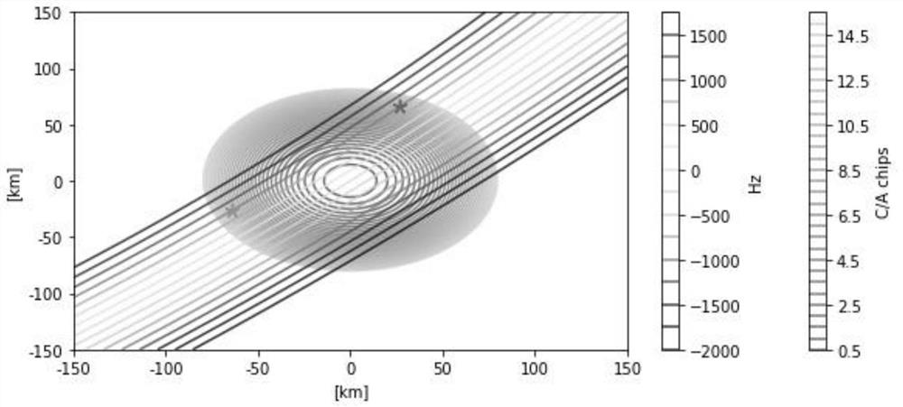
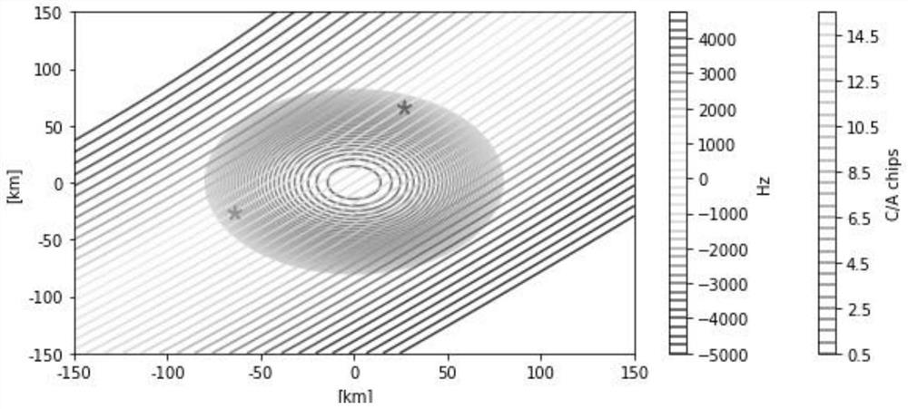
[0063] Step 1. Analyze the GNSS-R signal scattering geometry on the sea surface

[0064] Since GNSS-R adopts the dual-base observation mode, it receives GNSS direct and reflected signals to obtain sea surface wind field information, and the power of this forward scattering signal is stronger than that of back scattering, and its power also decreases with the increase of sea surface roughness. Small, its wind speed measurement accuracy is generally ≤2m / s, and wind direction measurement accuracy is generally ≤20°. Compared with other traditional load forms, the L-band signal of GNSS-R is less sensitive to cloud and rain, and can realize all-weather detection. Due to the characteristics of CDMA spread spectrum...


PUM


Abstract

The invention relates to a sea surface wind field inversion observation method based on satellite navigation information, and the method comprises the following steps: building a local coordinate system with a specular reflection point as an original point, and determining the geometrical relationship of a GNSS satellite, the specular reflection point and a GNSS-R receiver; dividing a scattering surface in space by using an equal delay line and an equal Doppler line, and mapping the distribution of scattering power of each divided region in space to a delay-Doppler domain; establishing an ocean remote sensing model; establishing a marine remote sensing related mathematical model; and utilizing a time delay-Doppler two-dimensional correlation power model to calculate the correlation power of the GNSS-R reflection signal, so that the reflection intensity of the reflection signal on different reflection surface units is obtained. According to the method, the internal relation of sea surface wind field inversion is fully analyzed, the wind field inversion model is established, and the reflection intensity of the reflection signal on different reflection surface units is explained through the time delay-Doppler two-dimensional correlation power value, so that the accurate observation function of the sea surface wind field is realized, and the method has the characteristics of high precision, convenience in measurement and the like.

Description

technical field [0001] The invention belongs to the technical field of marine surveying and mapping, in particular to a sea surface wind field inversion observation method based on satellite navigation information. Background technique [0002] The traditional sea surface wind field acquisition method mainly uses observation methods such as buoys, ships, and ocean stations. There are few observation points, and it is difficult to achieve large-scale simultaneous observation. [0003] Traditional spaceborne measurement instruments for marine environmental elements mainly include radiometers, scatterometers, altimeters, and synthetic aperture radar (SAR). Among them, the radiometer is a passive instrument, which is mainly used for the measurement of atmospheric contours, atmospheric / soil temperature and humidity, seawater salinity and other elements. Not high; the scatterometer is currently the most widely used sea surface wind field measurement instrument, its wind speed mea...

Claims


Application Information

Patent Timeline
Patent Type & Authority Applications(China)
IPC IPC(8): G01S19/37
CPCG01S19/37
Inventor 金际航李海滨王致芃闸旋袁延艺刘洪琛赵健李梦龙瞿宏博刘泽培
Owner THE CHINESE PEOPLES LIBERATION ARMY 92859 TROOPS
Why Eureka
Try Eureka