Supercharge Your Innovation With Domain-Expert AI Agents!

Land planning equipment based on remote sensing and use method thereof

A land and planning technology, applied in the direction of surveying instruments, instruments, surveying and navigation, etc., can solve problems such as inconvenient operation, resource integration obstacles, and inability to adjust, so as to improve the flexibility of use, facilitate operation and viewing, and improve work efficiency Effect

Active Publication Date: 2021-07-09
台州市地理信息测绘中心有限公司
View PDF6 Cites 0 Cited by
  • Summary
  • Abstract
  • Description
  • Claims
  • Application Information

AI Technical Summary

Problems solved by technology

[0004] But at present, in our country's national land survey work, managers still need to collect land use conditions on the spot, and mark them into different sections through the drawn maps. Although the personnel collection is relatively detailed, the work efficiency is low and the limitations are strong. There are also certain obstacles to the integration of resources. The process of land planning is not updated in time, resulting in a delay in the record of changes in land types. Therefore, a system that can not only improve land survey equipment but also integrate resources Some planning terminals cannot be flexibly adjusted according to the needs of use, which is not only inconvenient to operate, but also inconvenient to watch

Method used


Image

  • Land planning equipment based on remote sensing and use method thereof
  • Land planning equipment based on remote sensing and use method thereof
  • Land planning equipment based on remote sensing and use method thereof

Examples


Embodiment

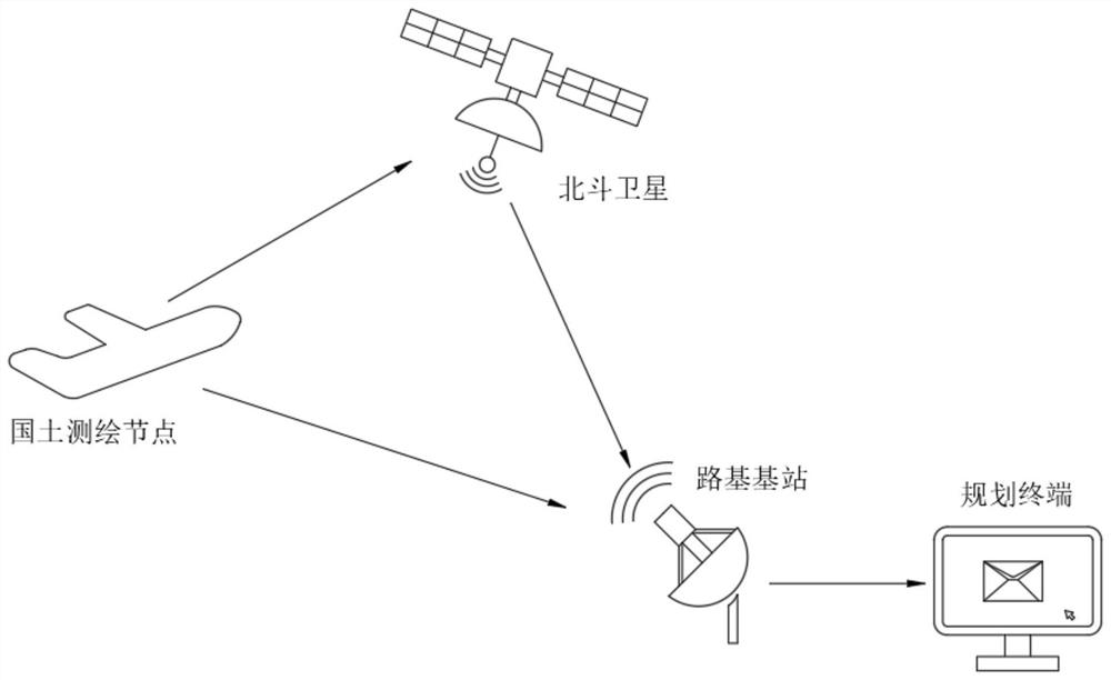
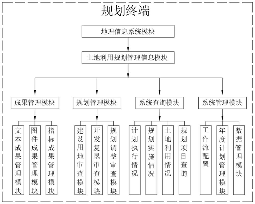
[0034]A land planning device based on remote sensing, including Beidou satellites, land surveying and mapping nodes, road-based base stations and planning terminals, the Beidou satellites are connected to the land surveying and mapping nodes through GPRS, the Beidou satellites are connected to road-based base stations through GPRS, the The land surveying and mapping node is connected to the road base station through GPRS, and the road base station is electrically connected to the planning terminal through optical fiber, which can carry out large-scale land monitoring, which can not only improve the speed of census, but also reduce the limitation of resource integration, thereby speeding up the survey. The update of land planning data, the planning terminal includes a geographic information system module, the geographic information system module is electrically connected to a land use planning management module, which can classify and integrate the database and planning progress,...


PUM


Abstract

The invention discloses land planning equipment based on remote sensing and a using method thereof. The land planning equipment comprises a Beidou satellite, a land surveying and mapping node, a roadbed base station and a planning terminal, and the Beidou satellite is connected with the land surveying and mapping node through GPRS. The land surveying and mapping node is used in cooperation with the Beidou satellite, large-area land monitoring can be conducted, the general survey speed is increased, the limitation of resource integration is reduced, the updating of land planning data isaccelerated, a land utilization planning management information system is built and used to carry out the automatic management of land resources under the support of the geographic information system module technology, the defects of a traditional working mode can be overcome, the database and the planning progress are classified and integrated, the data can be reflected more visually and clearly, the working efficiency is greatly improved, the planning terminal is adjusted, the use flexibility is greatly improved, and therefore operation and viewing of workers are facilitated.

Description

technical field [0001] The invention belongs to the field of land planning equipment, in particular to a remote sensing-based land planning equipment and a method for using the same. Background technique [0002] Land planning refers to the long-term arrangements made for the rational use of land in accordance with the prospects and needs of economic development within a country or a certain region. The basis is the distribution and allocation of existing natural resources, technical resources and human resources, so as to ensure that the land is fully and effectively used without causing waste due to man-made reasons. The overall plan for land use is within a certain area. The requirements of sustainable economic development and natural, economic and social conditions, the overall arrangement and layout of land development, utilization, management and protection in space and time. [0003] The land planning management information system is a professional system developed t...

Claims


Application Information

Patent Timeline
Patent Type & Authority Applications(China)
IPC IPC(8): G01C15/00G01S19/42G08C17/02G08C23/06
CPCG01C15/00G01S19/42G08C17/02G08C23/06
Inventor 吴振华
Owner 台州市地理信息测绘中心有限公司
Features
  • R&D
  • Intellectual Property
  • Life Sciences
  • Materials
  • Tech Scout
  • Unparalleled Data Quality
  • Higher Quality Content
  • 60% Fewer Hallucinations
Learn More