
Unmanned aerial vehicle flight path tracking identification method based on machine learning

A technology of machine learning and recognition methods, applied in the field of navigation deception, to achieve the effect of strong versatility

Active Publication Date: 2021-07-20
湖南省导航仪器工程研究中心有限公司
View PDF6 Cites 2 Cited by
  • Summary
  • Abstract
  • Description
  • Claims
  • Application Information

AI Technical Summary

Problems solved by technology

But on the other hand, accidents caused by unmanned aerial vehicles or improper operation are not uncommon.

Method used


Image

  • Unmanned aerial vehicle flight path tracking identification method based on machine learning
  • Unmanned aerial vehicle flight path tracking identification method based on machine learning
  • Unmanned aerial vehicle flight path tracking identification method based on machine learning

Examples


Embodiment Construction

[0024] The present invention will be described in detail below, and it should be understood that the content described here is only for explaining the present invention and not limiting the present invention.

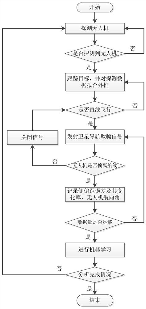
[0025] The flow chart of navigation deception signal generation and realization is as follows: figure 1 shown.

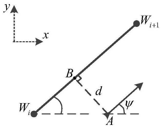
[0026] figure 2 It is the diagram of physical quantities such as side offset distance, side offset distance error change rate and UAV heading angle involved in the present invention, wherein x, y represent the x-axis and y-axis of the Cartesian coordinate system respectively, and W i W i+1 Indicates the planned track (straight line), A is the current position of the drone, ψ is the angle between the flight direction of the drone and the x-axis, that is, the heading angle of the drone, AB⊥W i W i+1 , d=AB, d is side offset distance, is the rate of change of side offset;

[0027] The technical scheme adopted in the present invention is:

[0028] A meth...


PUM


Abstract

The invention belongs to the field of navigation deception, and particularly discloses an unmanned aerial vehicle flight path tracking identification method based on machine learning. The method comprises the following steps: (1) detecting whether an unmanned aerial vehicle exists and whether the unmanned aerial vehicle is in a linear flight state; (2) transmitting a satellite navigation deception signal to force the unmanned aerial vehicle to deviate from the planned route; (3) recording the lateral offset distance error, the lateral offset distance error change rate and the course angle information of the unmanned aerial vehicle; (4) taking the lateral offset distance error and the lateral offset distance error change rate as input, taking the course angle of the unmanned aerial vehicle as output, and establishing an input and output mapping relation through machine learning methods such as a support vector machine; and (5) predicting the course angle change of the unmanned aerial vehicle through a satellite navigation deception signal based on a model established by machine learning, thereby achieving the purpose of navigation deception. The method is high in universality, can provide technical support for management and control of the illegal unmanned aerial vehicle, and effectively expel and decoy the illegal unmanned aerial vehicle to a designated place.

Description

technical field [0001] The invention relates to the field of navigation deception, in particular to a method for tracking and identifying unmanned aerial vehicles based on machine learning. Background technique [0002] With the advancement of satellite navigation technology and the opening of low-altitude airspace, the UAV industry has developed rapidly and has been widely used in geological exploration, disaster relief, traffic control, agricultural fertilization, pollution monitoring, etc. But on the other hand, accidents caused by drones flying black or improperly operated are not uncommon. Effective control of UAVs is imminent. At present, the main disposal methods include: suppression of interference, navigation deception, link hijacking and hard killing and destruction. Among them, navigation deception methods are highly versatile and effective, and can lure UAVs to designated locations. attention to the location. [0003] The present invention starts from the reali...

Claims


Application Information

Patent Timeline
Patent Type & Authority Applications(China)
IPC IPC(8): G01S19/21G01S19/42G01S19/52G01S19/53G06N20/00
CPCG01S19/215G01S19/42G01S19/52G01S19/53G06N20/00
Inventor 杨俊马超郭熙业周超胡梅
Owner 湖南省导航仪器工程研究中心有限公司
Learn More